
Quesnel Timber Supply Area
The Quesnel Timber Supply Area (TSA) covers approximately 1.28 million hectares and includes the city of Quesnel, and the communities of Red Bluff, Barlow Creek, Dragon Lake and Bouchie Lake. Other communities within the Quesnel TSA include Wells in the east, and Nazko and Kluskus villages in the west.
The Quesnel TSA is located in the northern part of the Cariboo Natural Resource Region, lying in the Fraser Basin and the Interior Plateau between the Coast Mountains on the west and the Cariboo Mountains on the east. To the west of Quesnel and of the Fraser plateau, the TSA includes the Itcha-Illgachuz mountain ranges, to the east lie the Quesnel Highlands, Barkerville, and the Cariboo River.
Effective June 16, 2017, the AAC for the Quesnel TSA is 2,607,000 cubic metres, of which 1,250,000 cubic metres is attributed to live coniferous trees, 1,230,000 cubic metres is attributed to dead trees, and 127,000 cubic metres is attributed to deciduous‑leading stands.
Adjusted Allowable Annual Cut (AAC)
Effective September 1, 2024, following a Community Forest Agreement (CFA), the AAC was adjusted to 2,537,081 cubic metres. When a CFA is issued, the TSA’s AAC is adjusted to reflect the land removed from it, per the Allowable Annual Cut Administration Regulation.
News release
- Cut level decreased for Quesnel Timber Supply Area (PDF, 486KB)
Reference # 2017FLNR0122-001246 * Released on June 16, 2017
Current Timber Supply Review
- Rationale for AAC Determination (PDF, 718KB)
- Discussion Paper (PDF, 924KB)
- Data Package (PDF, 812KB)
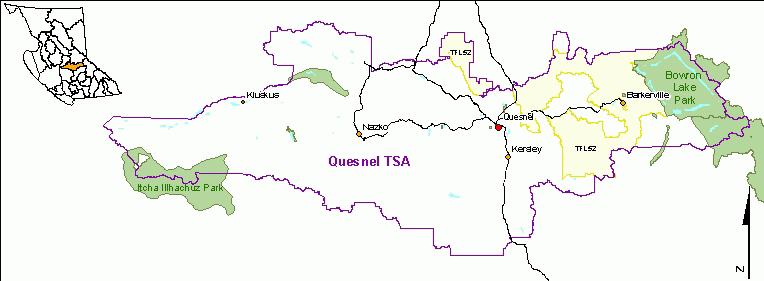
West of Quesnel and the Fraser plateau, the Quesnel TSA includes the Itcha-Illgachuz mountain ranges. To the east lie the Quesnel Highlands, Barkerville and the Cariboo River.
Contact information
Public input is a vital part of the timber supply review process. Feedback is welcome on any issues related to the timber supply review for the Invermere TSA.