
Hunting and Trapping Regulations Synopsis
On this page
Hunting and Trapping Regulations Synopsis

The 2026-2028 Hunting and Trapping Regulations Synopsis (PDF, 13MB) is a summary of the B.C. hunting and trapping regulations made under the Wildlife Act, prepared for the convenience of hunters and trappers.
The regulations synopsis:
- Sets out general hunting information
- Summarizes important hunting regulations
- Defines open seasons with maps indicating closed areas
The 2026-2028 Hunting and Trapping Regulations Synopsis is effective from July 1, 2026 to June 30, 2028.
For a summary of the changes and why they have been made, consult the 2026 Hunting and Trapping Regulations Changes Summary (PDF, 180KB).
Corrections and updates: Changes to hunting and trapping regulations are updated in the online version of the synopsis and specific details are listed on Hunting and Trapping Regulation Synopsis corrections and updates.
Regulations by region
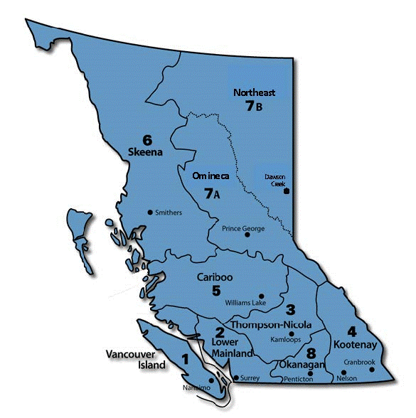
Management unit maps
The province is divided into nine administrative regions, having a total of 225 management units (MU) for the purpose of game management. Each unit is identified by number and is shown with its boundaries delineated in black dashed lines on the following maps:
- Region 1: Vancouver Island (PDF, 27MB)
- Region 2: Lower Mainland (PDF, 28MB)
- Region 3: Thompson (PDF, 36MB)
- Region 4: Kootenay (PDF, 34MB)
- Region 5: Cariboo (PDF, 42MB)
- Region 6: Skeena (PDF, 43MB)
- Region 7A: Omineca (PDF, 48MB)
- Region 7B: Peace (PDF, 44MB)
- Region 8: Okanagan (PDF, 26MB)
Detailed Hunting and Trapping Synopsis maps
The following maps represent some of the areas where portions of a management unit are open/closed during the General Open Season or areas where hunting/shooting is restricted or prohibited. Not all maps within the Hunting and Trapping Regulations Synopsis are include here. Refer to the current 2026-2028 Hunting and Trapping Regulations Synopsis (PDF, 13MB) for more details and other boundary information including, but not limited to:
- Species closed areas
- Management unit boundaries
- No hunting/shooting areas
Road data is not up-to-date and roads depicted may not exist. New roads from 1995 onwards may not be shown on maps. The following maps are poster size maps and will not be legible if printed on standard 8.5x11 inch paper. You will be able to zoom in and take note of boundary details.
These maps may contain references to previous ministers or ministries responsible for wildlife at the time of publication. Periodic transfer of authority for natural resource management may not be reflected in these documents.
Note: Visit motor vehicle prohibitions for information and detailed maps regarding areas where vehicle use is restricted.
Region 1: Vancouver Island
Special antlerless mule deer
Adult hunters are only permitted to hunt antlerless deer in the designated Special Antlerless Mule Deer areas within these management units:
- MU 1-2
- MU 1-4
- MU 1-5
- MU 1-6
- MU 1-15
Special Antlerless Mule Deer areas are "Bow" or "Firearms Using Shot" only. The maps below are more detailed to help supplement those provided in the Regulations Synopsis:
- Campbell River to Courtenay (PDF, 189KB)
- Courtenay to Nanaimo (PDF, 193KB)
- Nanaimo to Finlayson Arm (PDF, 227KB)
No hunting or shooting areas
Region 2: Lower Mainland
No hunting or shooting areas
Region 3: Thompson
Mountain sheep
No hunting or shooting areas
Region 4: Kootenay
Mule deer and white-tail deer
- January 5-31, 2026 Cranbrook area deer hunt (PDF, 4.8MB)
- January 5-31, 2026 Cranbrook area deer hunt - detailed map (PDF, 6.7MB)
- Cranbrook January 2026 Deer Hunt – Fact Sheet (PDF, 131KB)
Elk
- South Trench Elk Zone (PDF, 1.8MB)
- North Trench Elk Zone (PDF, 9MB)
- Creston Elk Zone (PDF, 7.4MB)
- Elk Valley Elk Zone (PDF, 4.2MB)
No hunting or shooting areas
Region 5: Cariboo
Black bear
- Korich/Kainet/Culpepper Lagoon/Salmon Bay Black Bear Hunting Seasons (PDF, 1.8MB)
- Black Bear No Hunting Areas in MU 5-9 (PDF, 15MB)
Grouse
Mountain goat
No hunting or shooting areas
- No Hunting Area 400m Elkin Creek-Lord River FSR (MU 5-4) (PDF, 700KB)
- No Hunting Area - 400m Chilko-Newton Road (MU 5-4 and 5-5) (PDF, 2.8MB)
Single projectile areas
Region 6: Skeena
These maps are geo-referenced PDFs that can be downloaded to electronic devices with mapping programs such as Avenza maps. This will allow users to see where they are in relation to the boundaries of the zones.
Black bear
Moose
No hunting/shooting areas
- Kwaal/Kitkiata Seasonal No Hunting Area (MU 6-3) (PDF, 5.4MB)
- Hudson Bay Mountain and Smithers Community Forest No Shooting Area (MU 6-9) (PDF, 3.4MB)
- Shaman Island No Shooting or Hunting Area (PDF, 787KB)
- Highway 113 No Shooting or Hunting Area (PDF, 16.9MB)
Single projectile areas
Region 7A: Omineca
Caribou
Mountain goat
Region 7B: Peace
Muskwa-Kechika Access Management Area (PDF, 3.2MB)
Bison
- Bison General Open Season in Portion of MU 7-42 (PDF, 3.7MB)
- Bison General Open Season in Portions of MUs 8-57 and 7-58 (PDF, 3.9MB)
Moose
- Compulsory Inspection Requirements in Portions of MU 7-52 (PDF, 9.1MB)
- Portions of MUs 7-52 (Barney Lake area) closed to moose hunting October 1-15 (PDF, 3.4MB)
- Portions of MUs 7-52 (Fireside/Coal River area) and 7-53 (Smith River Watershed) closed to moose hunting October 1-15 (PDF, 1.1MB)
- Moose Closed Season Area in MU 7-31 (PDF, 6.8MB)
- Moose Closed Season Area in MU 7-51 (PDF, 8.2MB)
Mountain goat
- Toad River Mountain Goat Closed Area (MU 7-51) (PDF, 1.6MB)
- Toad River Mountain Goat Closed Area (MU 7-54) (PDF, 1.5MB)
No hunting or shooting areas
Region 8: Okanagan
No hunting or shooting areas
Fraser Valley Special Hunting Areas
A Fraser Valley Special Area Hunting Licence (PDF, 21MB) is required to hunt anywhere within provincial Management Unit 2-4 and parts of Management Unit 2-8 within Maple Ridge, Pitt Meadows, Mission and Coquitlam.
Hunting in parks
For information on hunting in provincial parks, visit BC Parks' fishing and hunting guide. To see if the park you are planning to visit allows hunting, check the park’s webpage.
Trapping in B.C.
The 2026-2028 Trapping Regulations (PDF, 236KB) is a summary of the B.C. trapping regulations included in the 2026-2028 Hunting and Trapping Regulations Synopsis (PDF, 12MB). For more information on trapping, visit Trapping in B.C.