
Great Bear Rainforest legal direction and agreements
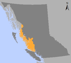
The Great Bear Rainforest is a global treasure that covers 6.4 million hectares on British Columbia’s North and Central Coast. It is the largest intact temperate coastal rainforest in the world and B.C. is home to 25 percent of the world’s remaining temperate coastal old-growth rainforest.
The GBR agreements emerged from local communities’ and First Nations’ desire for more sustainable practices in regional conventional land use planning and forest management. Ecosystem-Based Management (EBM) was conceived, an approach intended to protect and conserve ecosystem integrity while maintaining and enhancing the well-being of local communities.
In 2009, government-to-government negotiations between the Coastal First Nations, Nanwakolas Council, and the Province of B.C. resulted in creation of the Great Bear Forest Carbon Projects, large-scale forest carbon offset projects that were the first of their kind in Canada. Revenues derived from the sale of carbon offsets have enabled First Nations to play a key role in the implementation of the GBR agreements, including working in partnership with the Province of B.C. to develop and oversee implementation of EBM regulation and policy including assessment and monitoring of carbon sequestration.
Legal direction and orders
Orders
- Great Bear Rainforest Land Use Objectives Order - 2023 (PDF, 740KB)
- Schedule A: Great Bear Rainforest Order Area (Landscape Units Covered by this Order) (PDF, 1.2MB)
- Schedule B: Central and North Coast Area (PDF, 1.2MB)
- Schedule C: South Central Coast Area (PDF, 1.2MB)
- Schedule D: Grizzly Bear Habitat (PDF, 1.4MB)
- Schedule E: Important Fisheries Watersheds (PDF, 1.5MB)
- Schedule F: Site Series Group Minimum Old Forest Retention Levels Less than 20% (by LU) (PDF, 130KB)
- Schedule G: Old Forest Targets (Order Area) (PDF, 195KB)
- Schedule H: Potential Tree Height (PDF, 170KB)
- Schedule I: Indigenous Heritage Features (Type 1 and 2) (PDF, 105KB)
- Schedule J: Indigenous Forest Resources (PDF, 145KB)
- Schedule K: South Central Coast Section 11(4), 12(4) Alternate Option (PDF, 110KB)
- Schedule L: Section 16(1), 16(2) Matrix Site Series Groups (PDF, 135KB)
- Schedule M: Section 16(1) Matrix Site Series Groups (PDF, 130KB)
- Schedule N: Red-Listed Plant Communities (PDF, 170KB)
- Schedule O: Blue-Listed Plant Communities (PDF, 145KB)
- Schedule P: Klinaklini River, Viner Creek Reserves Zones (PDF, 1MB)
- Schedule Q: Cedar Stewardship Areas (PDF, 1.3MB)
- Schedule R: Kermode Stewardship Areas (PDF, 1.3MB)
- Schedule S: Site Series Groups (PDF, 140KB)
- Old Forest Target Implementation Support
- Central and North Coast Biodiversity, Mining and Tourism Area Order (Order-In-Council 0002-2009)
- Overview Map of Central Coast Biodiversity, Mining and Tourism Areas (BMTAs) (PDF)
- Overview Map of North Coast Biodiversity, Mining and Tourism Areas (BMTAs) (PDF)
- Adeane Point BMTA Map (PDF)
- Alwyn Lake BMTA Map (PDF)
- Ape Lake BMTA Map (PDF)
- Banks/Principe BMTA Map (PDF)
- Barer Creek BMTA Map (PDF)
- Bentinck Estuaries BMTA Map (PDF)
- Citeyats BMTA Map (PDF)
- Fish Egg BMTA Map (PDF)
- Gits'oohl BMTA Map (PDF)
- Inland Cape Caution BMTA Map (PDF)
- King BMTA Map (PDF)
- Ksi Galsgiist BMTA Map (PDF)
- Kswan BMTA Map (PDF)
- Kunsoot River BMTA Map (PDF)
- K'waal-Ecstall BMTA Map (PDF)
- Nekite BMTA Map (PDF)
- Porcher BMTA Map (PDF)
- Rachael Islands BMTA Map (PDF)
- Shelter Bay BMTA Map (PDF)
- South Bentinck BMTA Map (PDF)
- Waump BMTA Map (PDF)
Spatial data
Rescinded orders
- Great Bear Rainforest Land Use Objectives Order - 2016 (PDF, 550KB)
- Schedule A: Great Bear Rainforest Order Area (Landscape Units Covered by this Order) (PDF, 2.1MB)
- Schedule B: Central and North Coast Area (PDF, 1.8MB)
- Schedule C: South Central Coast Area (PDF, 1.7MB)
- Schedule D: Grizzly Bear Habitat (PDF, 2.1MB)
- Schedule E: Important Fisheries Watersheds (PDF, 2.1MB)
- Schedule F: Site Series Group Minimum Old Forest Retention Levels Less than 20% (by LU) (PDF, 210KB)
- Schedule G: Old Forest Targets (Order Area) (PDF, 341KB)
- Schedule H: Restoration Landscape Units (Type 1 & 2) (PDF, 170KB)
- Schedule I: Aboriginal Heritage Features (Type 1 & 2) (PDF, 175KB)
- Schedule J: Aboriginal Forest Resources (PDF, 270KB)
- Schedule K: Section 4 (3) Landscape Units (PDF, 170KB)
- Schedule L: Section 4 (3), 4 (5) Matrix Series Groups (PDF, 185KB)
- Schedule M: Section 4 (6) Matrix Series Groups (PDF, 180KB)
- Schedule N: Red-Listed Plant Communities (PDF, 265KB)
- Schedule O: Blue-Listed Plant Communities (PDF, 240KB)
- Schedule P: Kimsquit River, Klinaklini River, Viner Creek Reserves Zones (PDF, 1.9MB)
- Schedule Q: Cedar Stewardship Areas (PDF, 1.9MB)
- Schedule R: Kermode Stewardship Areas (PDF, 1.9MB)
- Schedule S: Site Series Groups (PDF, 235KB)
- 2013 Order Establishing Objectives for the South Central Coast (Consolidated) (PDF, 8.2MB)
- 2013 Order Establishing Objectives for the Central and North Coast (Consolidated) (PDF, 8.1MB)
Agreements with First Nations
- Coastal First Nations Protocol (2006) (PDF, 4MB)
- KNT Agreement in Principle (2006) (PDF, 6.3MB)
- Gitxaala Sustainable Land Use Planning Agreement (2006) (PDF, 4.2MB)
- Haisla Strategic Land Use Planning Agreement (2006) (PDF, 2.5MB)
- Heiltsuk Strategic Land Use Planning Agreement (2006) (PDF, 2.5MB)
- Kitasoo / Xaixais Strategic Land Use Planning Agreement (2006) (PDF, 2.3MB)
- Kitselas Strategic Land Use Planning Agreement (2006) (PDF, 1.6MB)
- Kitsumkalum Strategic Land Use Planning Agreement (2006) (PDF, 1.7MB)
- Metlakatla Strategic Land Use Planning Agreement (2006) (PDF, 3.5MB)
- Wuikinuxv Strategic Land Use Planning Agreement (2006) (PDF, 9.4MB)
Central and North Coast land and resource management plans
Plan Type: EBM Implementation
Plan Status: Approved, legally established
Plan Area: 6,433,267 hectares
Natural Resource Region: West Coast, Skeena
Natural Resource Districts: Campbell River, North Island - Central Coast, Coast Mountains
Timber Supply Areas: GBR North, GBR South, Pacific, TFL 39 and 45
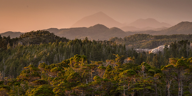
The Great Bear Rainforest is a global treasure that covers 6.4 million hectares (more than twice the size of Belgium) on B.C.’s north and central coast. All British Columbians have a stake in protecting it.
Follow news and updates about the Great Bear Rainforest.
Contact information
Contact us if you have questions about the Great Bear Rainforest.