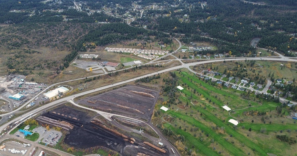
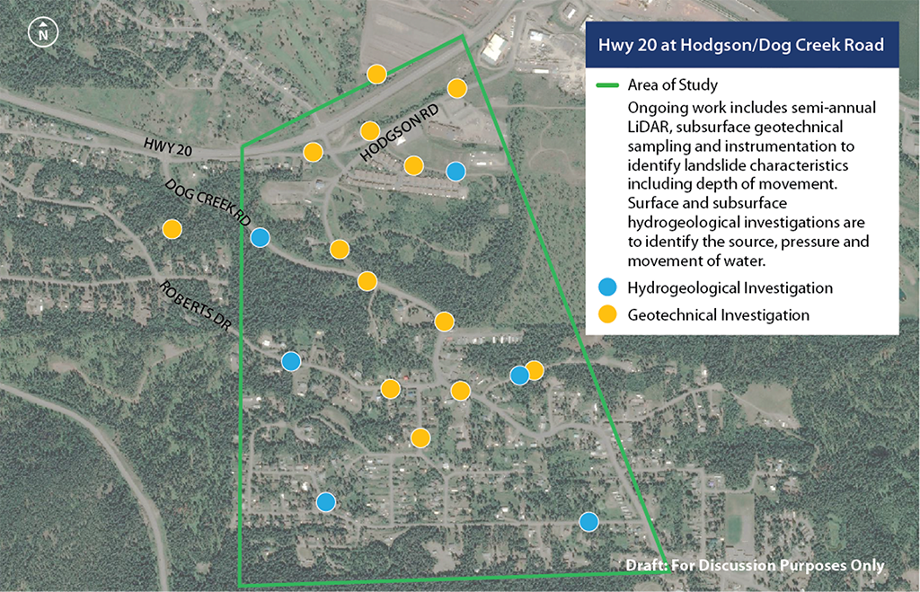
Highway 20 at Hodgson/Dog Creek Road

Open. Dog Creek Slide erosion mitigation construction complete. Geotechnical investigations and analysis, and surface water management upgrades for the ancient Hodgson Slide ongoing.
2025 Onsite works complete
A number of activities were completed in the project area in 2025, including the following:
- Surface water management improvements
- Upper project area (Richard Road, Bann Road, Opal Street, Shaw Road, Roberts Drive): Roadside ditch improvements, culvert installation, grass seeding, erosion control (coco matting) and paving
- Wotzke Drive/Hodgson Road/Terra Ridge area: Culvert/headwall installation, ditch improvements, grass seeding, erosion control and paving
- Highway 20-South Lakeside Drive intersection: Roadside ditch improvements, hydroseeding and erosion control; paving and asphalt curb work was also completed at the Tolko access off Highway 20
- This concludes the surface water infrastructure upgrades that started in 2023, to improve the movement of rainwater and snow melt from the upslope area of the project to the downslope area
- Dog Creek Slide
- Grass seeding and erosion control around the perimeter of the slide area
- Hodgson Slide
- Installation of the second of two meteorological stations in the area to monitor precipitation and barometric pressure
- Continued instrumentation monitoring and engineering analysis
- Residential well sampling and installation of instrumentation to monitor groundwater quality and groundwater levels
Next steps for potential Hodgson Slide mitigation are expected to be determined in 2026. Once more information is available, another update will be provided to the community.
Location map

Highway 20 at Hodgson Road/Dog Creek Road, southwest of Williams Lake.
Status
Highway 20 is open and is safe for public travel through the slide area. Long-term restoration options are currently being explored to determine a safe and climate resilient solution for the Hodgson slide.
Work includes:
- Research on soil and water
- Environmental reviews and on-site inspections
- Interim drainage and slope improvements
Traffic impacts
Notification of project-related fieldwork or construction is posted on this page in advance. For the latest information on road conditions, please visit DriveBC.
Timeline
We will have more information on timelines when our technical work on the Hodgson Slide is complete.
Public engagement
Information session
Spring 2024
An information session was held in Williams Lake on June 4, 2024 regarding the Highway 20 at Hodgson/Dog Creek Road Project.
You can share your feedback with the project manager. Use the subscribe feature to be informed of opportunities for public engagement and updates to this page.
Archive
Progress updates
2024 Onsite works complete
A number of activities were completed in the project area in 2024, including the following:
- Surface water management: This work consists of upgrades to drainage infrastructure to support the movement of rainwater and snow melt from the upslope area of the project to the downslope area. Culverts were installed underneath Highway 20 near South Lakeside Drive and at the Highway 20-Hodgson Road intersection to provide more capacity for surface water as it flows, ultimately, to Williams Creek. Upgrades to ditches, culverts and piped systems in the upslope area of the project (Shaw Road, Bann Road, etc.) were also completed and now tie into the surface water works completed in 2023.
- Hodgson Slide: Geotechnical investigations and engineering analysis of monitoring results continued as the technical team develops slide mitigation options. Residents may see crews onsite over the winter to install and/or read instrumentation as the project team continues to gather information on the subsurface conditions of the Hodgson Slide.
- Dog Creek Slide: Erosion mitigation construction was completed. Crews regraded the slope of the slide, placed a rock blanket, and restored the ditch at the bottom of the slide.
More information on the surface water management strategy, Hodgson Slide mitigation and Dog Creek Slide mitigation can be found by clicking on the Presentation Display Boards link in the Public Engagement section.
November 2023
An information session was held in Williams Lake on November 15, 2023 regarding the Highway 20 at Hodgson/Dog Creek road Project
September 2022
The Cariboo Regional District and the City of Williams Lake released a study identifying areas of land movement in the area over three years.
July 2022
Well water testing was conducted at residences in Williams Lake as part of further investigations of the slides.
March 2022
A program-wide engagement period was held to introduce the public to the projects, providing context and an overview of the background, process, and short-listed options being explored.
December 2021
Geotechnical investigations, including drilling work, were completed on-site. Subdivision took place.
November 2021
An in-person drop-in session at Kersley Hall was held to provide updates on the Highway 20 at Hodgson Road Project.
September 2021
The rideability of the road was improved, including all four lanes and several hundred meters of paving.
Summer 2021
Sections of Highway 20 and portions of provincial side roads damaged by ground movement were repaired.
Spring 2021
During the spring freshet, multiple historic landslides were reactivated along Highway 20 at Hodgson/Dog Creek Road.
News
Road Projects Improve Safety, Reliability in the Cariboo - April 30, 2025
BC’s Historic Landslides - What They Are and How We Manage Them - May 3, 2022
Notifications
July 2025
A number of activities are underway or were completed in the project area this summer, including the following:
- Work Started in summer and continued into the fall, crews and equipment will be onsite to continue upgrades to drainage infrastructure in the Project area.
- Work will be taking place throughout the Project area and at the Highway 20-South Lakeside Drive intersection.
- This work follows the drainage construction activities completed in fall 2023 and last winter.
March 2025
Through March, crews will be onsite at various locations within the project area to gather monitoring information as part of ongoing project planning. Crew members will be wearing vests, and drivers are asked to use caution if crews are working near a road.
November 2024
A number of activities are underway or were completed in the project area this fall, including the following:
- Surface water management construction: Until early December, crews will be installing drainage infrastructure underneath Highway 20 near South Lakeside Drive. This work, which includes upgrades to ditches, culverts and piped systems to support the movement of rainwater and snow melt from the upslope area of the project to the downslope area, requires intermittent Highway 20 lane closures. At least one lane in each direction will be maintained during construction and signage and traffic control is in place. Ditching and culvert upgrades in the upslope area of the project (Shaw Road, Bann Road, etc.) are scheduled to resume in 2025.
- Hodgson Slide mitigation options development: Residents may see crews onsite to install and/or read instrumentation, as the project team continues to gather information on the subsurface conditions of the Hodgson Slide.
- Dog Creek Slide erosion mitigation construction is complete. Crews regraded the slope of the Dog Creek Slide, placed a rock blanket, and restored the ditch at the bottom of the slide. Hydroseeding work is expected to be done in the coming weeks.
More information on surface water management, Dog Creek Slide mitigation and Hodgson Slide mitigation can be found by clicking on the Presentation Display Boards link in the Public Engagement section below.
September 2024
Activity in the project area is increasing this fall, starting with construction for the second phase of surface water management work. Starting in early September and continuing for approximately six weeks, crews will install drainage infrastructure underneath Highway 20 near the Fairview Drive/Terra Ridge intersection.
This work, which includes upgrades to ditches, culverts and piped systems to support the movement of rainwater and snow melt from the upslope area of the project to the downslope area, will require intermittent Highway 20 lane closures. At least one lane in each direction will be maintained during construction and signage and traffic control will be in place.
Geotechnical drilling within the Hodgson Slide area is also scheduled to resume mid-September. Residents may see drilling crews and equipment onsite, as the project team gathers more information on the subsurface conditions of the Hodgson Slide.
Dog Creek Slide erosion mitigation construction is anticipated to start later this fall. More information will be provided closer to the start of that work.
Drivers are asked to proceed with caution when crews are working near roads.
August 2024
This month, crews will be on-site at various locations within the project area to locate utility infrastructure. Additional site visits are expected as part of ongoing project planning – crew members will be wearing vests as they gather information within the project area. Drivers are asked to use caution if crews are working near a road.
April 2024
In April, crews will be carrying out an inventory of approximately 50 domestic water wells in the Hodgson Slide area as part of ongoing project planning. Crews will be requesting access to residential properties to take photo of wells and discussing any information residents can provide on their wells. The door-to-door survey is voluntary and crews will not collect any information without approval.
March 2024
Crews will be onsite multiple times in March to gather information as part of ongoing project planning. Residents in the area may see crew members wearing vests and walking throughout the project area. Drivers are asked to use caution if crews are tracking observations near a road.
February 2024
As a part of ongoing project planning, property survey work is being done within the Hodgson Slide area in February.
Residents in the area may see crew members walking the site in vests and using survey equipment to conduct their work.
Drivers are asked to use caution when passing through the area.
Fall 2023
Crews will be onsite this fall to perform two pieces of work: geotechnical drilling and Phase 1 of surface water management fieldwork.
- Geotechnical drilling of two boreholes in the Dog Creek slide area beginning in late October. Access construction for this work, including clearing and brushing, will be completed prior to the arrival of the drill rig. Crews will gather soil and water samples to inform project planning.
- Implementation of the first phase of surface water management is expected to run from early November through December and includes upgrades to existing infrastructure within Ministry of Transportation and Transit right-of-way. Crews will clear and widen ditches, decommission a culvert near the intersection of Wotzke Drive and Dog Creek Road, and install a new, realigned culvert. This work is a first step in supporting the movement of rainwater and snow melt from the upslope area of the project to the downslope area.
Traffic control will be in place as needed. To ensure the public’s safety, we ask residents to stay away from work areas.
September 2023
As part of ongoing project planning, field surveys are scheduled to take place within Ministry of Transportation and Transit right-of-way, starting the week of September 11, 2023. Crews will be surveying existing infrastructure located within the project area for approximately 8 days. Traffic impacts are not anticipated, but drivers should be aware that crew members will be working near roads.
Photo gallery
Subscribe
Enter your email address to subscribe to updates of this page.
