Mapping FAQ - Mineral Titles
All spatial data in MTO is projected in NAD 1983 BC Environment Albers (WKID: 3005). This is the spatial reference used to calculate areas and distances.
Most online mapping applications, including MTO use WGS84 Web Mercator (auxiliary sphere) (WKID:3857).
1. Open Mineral Titles Online at www.mtonline.gov.bc.ca .
2. Depending on the type of claim you want to view, click on a Mineral Map, Placer Map or Coal Map green button under ‘CWM Map Viewer’.
3. Find the claim using the map viewer. See the Title Search - Using the Map Viewer for step by step instructions.
4. Use the Identify Features Tool to view claim details. For more information about using the Map Viewer, see Quick Reference Guide to Common Web Mapping.
MTO shows live information as transactions are completed. If a transaction involve payment, there might be a slight delay as the database is only updated after payment has been confirmed.
Important note: The MTO application and map viewer is the only “Live” view of the Mineral Titles database. Other sources of MTO data, such as those provided by DataBC, may be at least one day out of date.
A cell may be unavailable for several reasons:
- If the cell status indicates “Available for acquisition” then you should be able to apply for a claim with the cell.
- If the cell status indicates “Unavailable – Covered by Reserve / Tenure / Park” then you will need to look for a title, reserve, park, or alienated land that might be covering the area. The identify result on the right side of your map viewer will provide a list of items to consider. Also, if the cell has less than 1 hectare of available ground, the cell is not made available and returns the same status result.
- If the cell status indicates “Unavailable – MEM” then the Mineral Titles Branch has made the cell unavailable for an administrative reason.
Occasionally, a cell will appear as unavailable, but it should be available. This is due to an incorrect cell status which can be fixed. If you cannot find any obvious reason for the cell to be unavailable, please send an email with the Cell Key ID to to Mineral.Titles@gov.bc.ca and we will review.
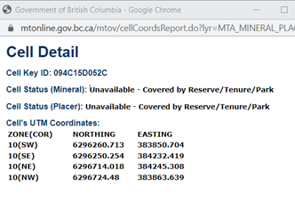
Use the Identify Feature Tool to retrieve the cell status and click in the target cell. A Cell Detail window will pop-up showing the cell status. The pop-up window displays both the mineral and placer cell status of the selected cell.
In the Cell Detail window, if the cell was abandoned, reduced, or forfeited, the date and time when the cell will become available will be shown. For example:
Cell Status (Mineral): Unavailable until 2009-12-14 10:00:00 due to abandonment, reduction or forfeiture.
A cell can be unavailable because it completely overlaps an existing title, park, mineral reserve r other alienated land. In this situation, the message below appears in the Cell Detail window when a cell is selected:
Cell Status (Placer): Unavailable - Covered by Reserve/Tenure/Park
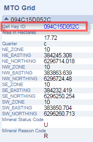
If the Cell Detail window didn’t display , you can view the cell details in the Identify results on the right side of the screen. Click on the blue arrow next to the cell ID to expand the information.
Next, click on the blue hyperlinked Cell Key ID.
The Cell Details window will pop up displaying the status:
Note: Placer claims may only be applied for in Designated Placer Claim Areas or Placer Claim and Lease areas.
For more information about using the Identify Feature Tool and Map viewer, see the Quick Reference Guide to Common Web Mapping .
Yes.
This layer has been added under the Other Mining Layers. The layer is called ‘MTA – Crown Granted Mineral Claims’ and must be added to display in the map viewer. It is not a layer that automatically is displayed when the map is opened.
See the Layers section in the Quick Reference Guide to Common Web Mapping to learn how to make layers visible in the map viewer.
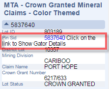
Using the Identify Feature Tool in the map viewer, select the Crown Grant of interest. The Crown Grant information will appear in the Identify results on the right side of the screen under MTA-Crown Granted Mineral Claims. Clicking on the PIN SID number as shown below will take you directly to Tantalis GATOR where you can find more details about the crown granted 2 post mineral claim.
For more information about coordinates in the Map viewer, see the Quick Reference Guide to Common Web Mapping.
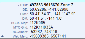
Coordinates can be displayed in UTM, latitude-Longitude, Decimal Degrees (DD) and Degrees, Minutes, Seconds (DMS), and other systems.
The default is UTM. If you want to change to another system like DMS, click on the dropdown arrow to the left of the coordinates displayed at the bottom left of the map viewer. You can select your preferred coordinate system and map coordinates will be displayed in your selected format.
Under the layers menu on CWM, you can upload local spatial files to display on the map.
Data BC manages the BC Data Catalogue that provides access to government’s data holdings including Mineral Titles data.
For step by step instructions on how to download data please see Downloading Spatial Data from the BC Data Catalogue on the Branch website.
The Dataset Descriptions & Download page lists all mineral titles data available for download from the BC Data Catalogue.
You can get the coordinates for your legacy claim by emailing a request to mineral.titles@gov.bc.ca.
Provide your name, MTO client number, email address and legacy claim number(s). Complete instructions, with examples, are available under Mineral Titles Legacy Claim Map Confirmation on the Mineral Titles Branch website.
No, Mineral Titles Online (MTO) is not recommended for measuring area and distance.
Converting 3D spatial data (i.e. a globe) onto a 2D plane (i.e. a paper map) introduces distortion and yields inaccurate results. Depending on the projection system, distortion can occur in any of the following forms: shape, area, direction, and distance. Projection systems are designed to limit one or more forms of distortion in lieu of increasing other forms of distortion.
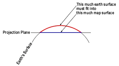
Source: The City University of New York[1]
MTO uses a Web Mercator projection system. Web Mercator is a pseudo-conformal projection system which preserves shape in lieu of area and distance. For Mercator projections, distortion increases with increasing distance from the equator (i.e. higher latitudes).
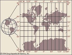
Source: Encyclopaedia Britannica[2]
Distortional error can be minimized by converting to the appropriate projection system. Unfortunately, MTO does not currently support projection conversion. In some cases, distortion can also be minimized using special formulas. However, the process can be complicated and does not account for all errors.
Using MTO to print physical maps and perform area and distance calculations may lead to additional errors. For example, using a physical map incorporates human and instrumental error. Moreover, a physical map lacks the ability to increase the scale detail in order to improve data accuracy.
The best course of action for accurately measuring area and distance is to contact a GIS professional in your local community.
For additional information regarding Mercator and distortion, please see the links below:
Measuring distances and areas when your map uses the Mercator projection
The Web Mercator Visual and Data Analysis Fallacy
Advisory notice on “Web Mercator”
FAQ: Why are my map, distance and area measurements wrong when using WGS 1984 Web Mercator?
[1] http://www.geography.hunter.cuny.edu/~jochen/GTECH361/lectures/lecture04/concepts/Map%20
coordinate%20systems/Map%20projections%20and%20distortion.htm
[2] https://www.britannica.com/science/Mercator-projection


