
Lesson 8– Field Based Upland/Riparian Indicators
![]()
Learning Objectives
This lesson covers exclusive upland indicators that will help you consider the condition of the riparian zone. Within your three transects you will locate disturbances that may suggest impacts within this buffer area.
In this lesson, you will learn:
-
Indicators to watch for in the upland buffer of the wetland.
-
How to identify and measure disturbances as you walk the transect
Tree Retention Upland from Wetland
You will measure the treed retention (buffer) area from the wetland's edge to the start of the cutblock or other human disturbance (e.g., cleared land), to a maximum of 100m. If there is only partial retention then you will estimate the amount of basal area at diameter at breast height (dbh) that remain within the retention area
Non-merchantable Conifers, Understory Deciduous Trees, Shrubs, and Herbaceous Vegetation Retained within 20m Upland from The Wetland
Record vegetation retained between the wetland edge and 20m upland. You will estimate the nonmerchantable conifers, understory deciduous trees, shrubs, and herbaceous vegetation that has been left behind within this zone. This can give you an idea of how fast the area may recover and if it can support wildlife. Since there are multiple layers (i.e., non-merchantable conifers, understory deciduous trees, shrubs, and herbaceous vegetation), consider each layer that would have been present prior to the harvest and weigh each equally. If all layers would have been present pre-disturbance, then weigh each with a total possible score of 25%. If only 3 would have been present, then assign each with a possible score of 33.3%, etc.
Recent Windthrow
While you're walking the upland portions of the transects, you will take note of any windthrow that has occurred since harvesting. If recent windthrow doesn’t exist or is minimal, then you do not need to complete this section. However, if you suspect excess windthrow since harvest, then this indicator is applicable.
You will compare old windthrow to new windthrow in order to determine if the rate of recent windthrow has increased beyond a percent threshold since harvest. You’ll only count trees which were growing within your assessment area, not those that fell into the assessment area, or those that were dead when they fell.
Old windthrow trees will show possible signs that they fell prior to recent harvest. Indicators of old windthrow may include:
- No green branches are present, and the tree shows a progression of more advanced decay;
- Bracket fungi will show more concentric rings on their tops than the age since recent harvest;
- The age of new vegetation growing on the root wad is older than the age since recent harvest;
- A moss layer is well developed on the tree.
Recent windthrow may still have green needles or leaves attached, intact bark and soil with fine root hairs seen in its root wad.
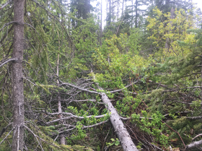
Photo: An example of recent windthrow.
Hydrologically Connected Bare Ground
Bare ground that is located upland may cause fine sediment to be deposited within the wetland. Bare ground hydrologically connected to the wetland anywhere around its perimeter is estimated and recorded. Possible sources of bare ground include road cuts, fill slopes, bladed trails, gouges, tipped over root wads and windthrow scares, slides and slumps, and animal or recreation trails.
Bare ground includes any soil or fill with particles smaller than 2mm that is not covered by plants, litter, lichen, moss, downed wood or coarse gravel. Evidence of sediment transport can include minor or major channels that form within the exposed soils and show evidence of flow, and possibly deposition, into the wetland. If encountered, you will measure the total size of the exposed area and then multiply by the fraction of fines (<2mm) and the fraction hydrologically connected to the wetland. By multiplying by these fractions, you are providing a more conservative estimate, and accounting only for exposed areas that will contribute to sediment transport.
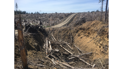
Photo: Sources of fine sediment that are hydrologically connected to a wetland to the right of the road.
LESSON 8: Self Check Questions
True or False:
- Beetle-killed timber that was left as retention and blew over after harvest is counted as windthrow.
- All bare ground within the Riparian Management Area is tallied as hydrologically connected to the wetland
Answers
- False- Trees that are dead at the time they blow down are not counted in the windthrow estimation.
- False – Only bare ground which is deemed hydrologically connected to the wetland with evidence of sediment transport is recorded. Upland areas with low slopes and well vegetated buffers adjacent to the wetland may limit sediment transport significantly.
Congratulations! 
You have now completed the Riparian / Wetlands online training!