
Lesson 3- Wetland Assessment Overview
Learning Objectives
This lesson briefly explains why wetlands are important, the concept of functioning condition, and how to identify the source of impairment to wetland condition indicators.
Why Wetlands are Important
Wetlands play a critical role in our environment that support both people and wildlife. They are involved in a number of ecological services that we as a society receive for free. Functions of wetlands include mitigating the impacts of flood events, filtering water, moderating stream flows, and providing key habitat for a number of our wildlife species.
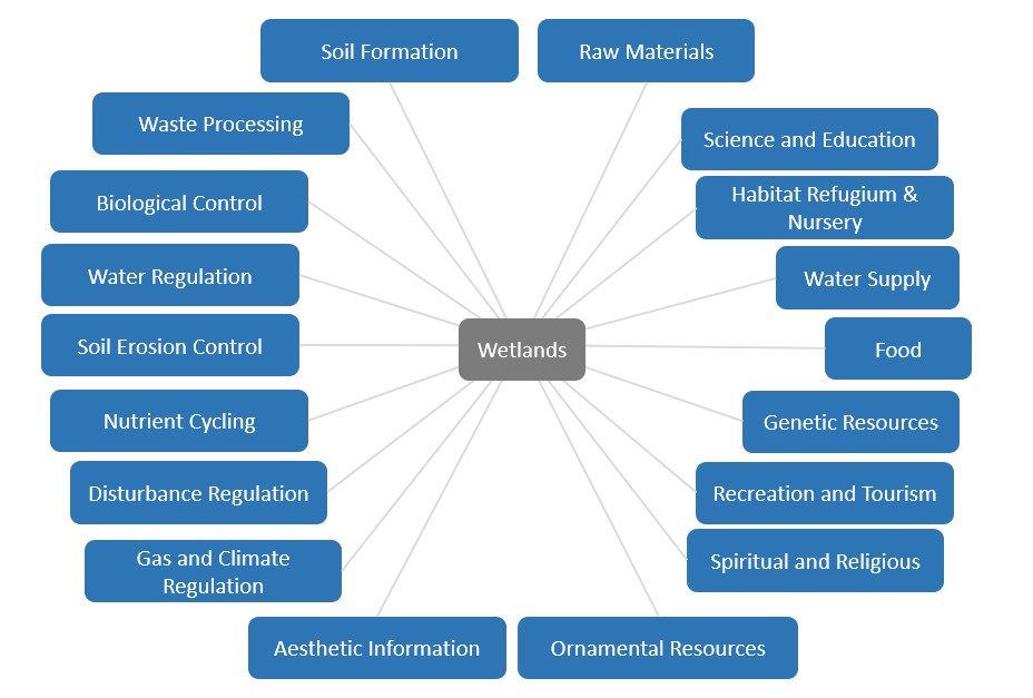
Furthermore, wetlands supply a high concentration of traditional medicines for many indigenous communities, and are frequently visited by hunters, wildlife enthusiasts and science educators. Despite their value on the landscape, we’ve globally lost 35% between 1970 and 2015.
Properly Functioning Condition
The WMREE will allow you to understand the inner workings of a wetland and explore the key conditions that support its functional health. At the end the assessment, users evaluate the wetland based on a series of attributes that were measured, counted or estimated to support “Yes” or “No” answers to indicator questions. A “No” answer indicates a component of the wetland may be impaired. The following breakdown determines the relative condition of the wetland based on the number of “No” answers to the 15 main indicator questions:
Properly functioning: 0–2 of the characteristics of wetland functioning are impaired
Functioning, but at risk: 3–4 of the characteristics of wetland functioning are impaired
Functioning, but at high risk: 5–6 of the characteristics of wetland functioning are impaired
Not properly functioning: 7 or more of the characteristics of wetland functioning are impaired
A wetland that is properly functioning has the ability to:
- Withstand inputs from upslope and inlets to filter runoff and improve downstream water quality;
- Support a variety of wildlife species, both within and directly surrounding the edge of the wetland by providing habitat niches and adequate cover through a diversity of well vegetated canopy layers, coarse woody debris, microtopography, and snags;
- Maintain the connectivity of fish habitats where these occur;
- Withstand hydrodynamic processes in terms of water input timing and quantity that is appropriate for the specific wetland’s composition and trajectory; and,
- Attenuate flooding events without erosion or modifications to vegetation types.
Causal Factors for Each “No” Answer
This is the last but crucial step in the FREP assessments. We want to know what caused each “no” answer, so we ask the assessors to record the main and specific causes of the problem. Sometimes this is obvious and other times it takes some exploration upslope.
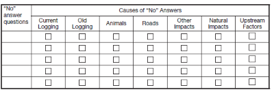
Identifying the main cause of impairment is a very important part of the assessment. We want to know if natural events, upstream factors, animal disturbance or development caused the “No” answer(s) to the indicator questions. This helps us distinguish and separate background impacts from treatment impacts.
If you do not know what is causing a question’s impairment, and it is obvious the management practices are not affecting this question, selecting “upstream factors” is acceptable for the main cause.
Specific Causes
For each of main causes identified, we ask the assessor(s) to take time to determine the specific factors involved to help managers know what they could do to improve their practices.
You will need to take a step back from the data collection and ponder causal relationships between management treatments, natural processes and their role in impairments to the functioning condition of a wetland. For example, RUNNING SURFACE EROSION or CROSSING STRUCTURE ISSUES are two of the specific causes that may be considered if ROADS are identified as a main causal factor. If ANIMAL DISTURBANCE is a main cause, it is helpful to identify whether LIVESTOCK, BEAVERS, or UNGULATES were the problem. It is possible that you will have two causal factors that have led to a single No answer. An example of this is when LIVESTOCK (main cause = Animal Disturbance) have disturbed the wetland because of increased access facilitated by LOW RETENTION (main cause = Current Logging).

Reviewing Riparian Treatments
When we visit a wetland, we want to first review the Site Plan for prescribed treatments within the riparian area, then check to see if they were implemented and whether they are effective. This is not a C&E step but a chance to give recognition of practices that are effective or not.
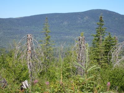
Photo: 5m MFZ with stubbed spruce & understory retained
Reviewing the riparian treatments is an important part of the WMREE assessment. It can be done as a focused review or concurrently while conducting the assessment. You will record the retention characteristics for the entire wetland in the Riparian/Buffer retention Information section of page 1 of the checklist. If you feel the information does not adequately describe the condition of the riparian area, provide a sketch on page 18 of the checklist. A photograph or two can also be invaluable in describing the riparian conditions.
As part of the assessment we wish to review whether the prescribed treatments were undertaken and if they were effective. This observation is to be noted on page 18 of the checklist. Effective would mean that the impacts to the wetland and riparian zone were not adverse. Determining if logging practices prescribed were fully implemented will take a bit of time and practice to observe. Here are a few examples of prescribed treatments:
Fall away: this is a practice where the hand fallers or mechanical feller buncher operator will ensure the trees are felled away from the wetland. For hand falling, this will be easy to determine by looking at the residual stumps. If the undercut is positioned facing opposite to the wetland’s position, then the tree was felled away. With bunchers, there is usually a “picket fence” of high cut stumps (or stubs) 1-4m in height indicating the operator was working the wood away from the stream.
Fall to span: this is a practice where the hand fallers had a heavy leaner and the tree was felled directly across an inlet or outlet stream channel. Subsequently the tree may have been removed, either by skidding or forwarding (lifting) the tree away from the stream. In this case, the stump will have an undercut positioned on the stream side of the stump.
Wind proofing: In some retention situations, the residual trees alongside the wetland will be treated to reduce the risk of post-logging windthrow. Typically, this will be evident by topping treatments (cut tops) by climbers or by helicopter. In some situations, the upper crown will have been spiral pruned by climbers and you will notice missing limbs usually cut flush or stub cut 5-20cm long. Another treatment regime is to profile cut trees out of the buffer. This is done by removing dominant and/or windthrow-prone trees from the harvesting edge. Consider also the width of RMZ retained, especially for wetlands with an RRZ – noting if the RMZ was effective in buffering the RRZ from windthrow.
Tree retention: In efforts to retain structural diversity and protect the shoreline, trees are sometimes left within the riparian zone. The selection criteria vary around the province. Look at the retention to see if it is still standing. To describe the level of retention, consider what tree layers were retained (vets, dominants, co-dominants, understory) or the types of trees (deciduous, conifers) or species, approximate basal area retained. This can be done using a quick prism sweep of trees retained and trees felled to get a proportion of retention).
Machine Free Zone: In this practice, merchantable trees are felled but the operator keeps the tracks of the machine a prescribed distance (commonly 5m) away from the stream banks. The feller buncher or forwarder is permitted to reach into the riparian area to fell and/or yard the trees. You will typically see a row of high stumps and/or residual flagging demarcating the machine exclusion zone. Additionally, most of the understory trees and shrubs will have been retained.
Designated stream crossings: In ground-based harvesting systems there is sometimes a need for the operator to cross an inlet or outlet stream to access trees/areas without having a constructed road. Refer to the map for approximate locations and then in the field look for a skid trail that leads across the stream. You may see some evidence of rutting or decked cull logs that had been used to build a temporary crossing.
LESSON 3: Self-Check Questions
True or False:
- A “not properly functioning” condition means all 15 of the main indicator questions received a “No” response.
- There can only be one causal factor assigned to each “No” answer.
Answers
- False: Seven or more “No” answers to the 15 indicator questions indicate a severely impaired state outside the range of natural variation, and thus assigned a “not properly functioning” status.
- False: In some cases, there may be more than one causal factor that led to an impact to one of the indicators. An example of this is livestock damage caused by increased access provided by a forestry road or new block.