
Bert Brink Wildlife Management Area
Date Designated: April 12, 2009
Purpose: Conservation of Fraser River floodplain with a biologically diverse habitat mosaic that supports a large number of both resident and migratory wildlife.
Size: 915 hectares
Region: South Coast
Nature and culture
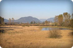
Fish and Wildlife: The Bert Brink WMA provides habitat for red and blue listed species including great blue heron, peregrine falcon, bald eagle, and marbled murrelet. The open fields are partly flooded in the winter and attract foraging wigeon and Canada geese. The sloughs, wetlands and gravel bars provide important habitat for White Sturgeon, Pacific Salmon and Steelhead Trout. The area includes over 200 hectares of mature cottonwood forest that can provide habitat for heron.
Physiography, Climate, and Vegetation: There are 311 hectares of upland and 604 hectares of foreshore included in the WMA thatare part of the Coastal Western Hemlock Dry Maritime ecosystem within the Fraser Lowland ecosection. The area is part of the undyked Fraser River floodplain and is made up of mature cottonwood forest, marshes, slough channels, open fields, and gravels bars.
Planning and management
Information on management direction and possible restrictions on visitor activities are available from the conservation Lands regional contacts.
Management Partners:

Bert Brink WMA is situated at the confluence of the Fraser River and Vedder Canal and includes a portion of Strawberry Island.