
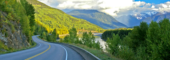
B.C. Highway Flood Recovery Projects

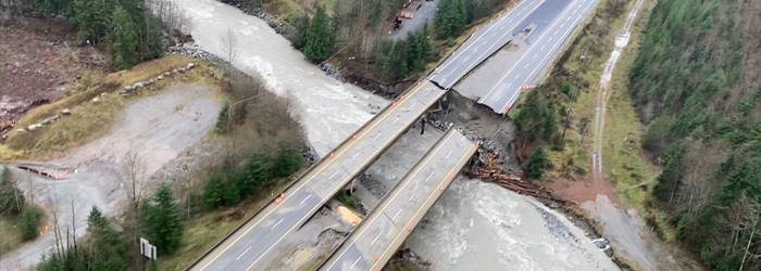
In November 2021, an atmospheric river brought an unprecedented amount of rain to the province just as winter was beginning. Highway infrastructure including roads and bridges was heavily impacted by the water. High water levels and slides damaged bridges and culverts, as well as large road sections. This resulted in cutting off main access routes to several areas of the province.
Slides can be complex and challenging to mitigate. They are often massive, and extremely difficult and expensive to stabilize.
The 2021 B.C. Highway Flood Recovery Projects are being undertaken to address the transportation impact on these routes (Highways 1, 3, 5, 7, 8, 11, 19, 99 and other side roads).
The people who build and maintain roads in B.C. have a reputation second to none, and their response to this disaster was remarkable. Working day and night they have completed temporary repairs that allowed many areas to reopen. However, the damage is extensive and will take years to fully recover.
Over the coming months project teams will be engaging with communities, local governments, Indigenous communities, and stakeholders to discuss the potential long-term transportation solutions at each project site.
Services and information topics
Highway 1 Fraser - Thompson
 (Traditional Projects at Nicomen Community Bridge, Thom's Crek and Gladwin Culver)")
Highway 1 Reinstatement Program, Fraser – Thompson Corridor is underway and may create travel delays throughout the corridor.
Highway 1 - Malahat Tunnel Hill

Highway 1 - Malahat Tunnel Hill Washout project was completed in October 2023.
Sunshine Coast

Work continues, repairing and increasing the resiliency of locations on the Sunshine Coast that were affected by the November 2021 atmospheric river event. Permanent construction repairs for all sites began in summer 2024, the construction at Kenyon Creek is complete. Construction at Day Road and Flume Creek will be completed by November 2025.
Highway 3

Work continues on Highway 3. Find out about current road status.
Highway 5 - Coquihalla
 between Hope and Merritt")
Recovery work on Highway 5 is complete, with all bridges restored to full capacity permanently.
Highway 7

Work continues on Highway 7. Find out about current road status.
Highway 8

The November 2021 Atmospheric River damaged 24 sites along Highway 8 between Spences Bridge and Merritt. Work continues on permanent repairs to the damaged sites to restore them to full capacity and make them more resilient to extreme weather.
Highway 11

Work continues on Highway 11. Find out about current road status.
Canal Road Dip Slide - Pender Island

The project will make permanent repairs to a section of Canal Road damaged during heavy rain and flooding in November 2021. It is located approximately 2.5 km east of the Pender Canal Bridge, which links North Pender Island and South Pender Island.
Silver Skagit Road

Silver Skagit Road is closed to the public for seasonal shutdown until April 15, 2025 and will not be maintained during this time.
Featured in B.C. Highway Flood Recovery Projects
DriveBC
Plan your route, find out about current road conditions, or report a highway problem.


Subscribe
Enter your email address to subscribe to updates of this page.
For more information visit:
Visit DriveBC for information about conditions and events that may be impacting travel on:
Related Links
Contact information
Friendly Url for this Page:
gov.bc.ca/highwayfloodrecovery
For more information contact:
250-387-3198
MOTI.WEBMASTER@gov.bc.ca