
Wόoshtin wudidaa Atlin Taku Land Use Plan
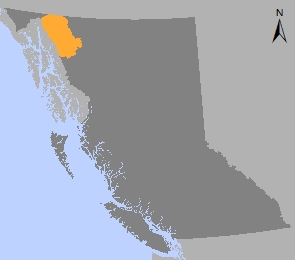
The Atlin Taku planning area is located in northwestern B.C. where the boreal forest, coastal mountains and Alaska panhandle meet. The planning area includes the Atlin Lake and Taku River watersheds in its approximately 3.1 million hectares.
Rich in untouched beauty, natural resources, cultural significance, history, and abundant wildlife, the area is of national, international and global significance. It remains one of North America's last true wilderness areas south of the 60th parallel.
The Wόoshtin wudidaa Atlin Taku Land Use Plan was negotiated under a shared decision-making framework respecting land use and wildlife management between the Taku River Tlingit First Nation and the B.C. government.
The framework established a process for government-to-government discussions related to land use planning, collaborative wildlife management planning, and the establishment of shared decision-making arrangements.
In 2009, land use objectives were established by an order that prohibited commercial forest harvesting in the areas of O'Donnel South, Hitchcock and Wilson Creek for a two-year period while a land use plan was being negotiated. Coinciding with the expiration of that order in 2011, the management direction in the Wόoshtin wudidaa Atlin Taku Land Use Plan was jointly developed and agreed to through government-to-government negotiations.
In 2014, an Order-In-Council under the Environment and Land Use Act was approved to legally implement the plan direction (Order Establishing Resource Management and Forest Retention).
The Order prohibits all hydro-electric development in the Racine Falls resource management area and limits hydro-electric development in three other resource management areas:
- Hoboe-Willison Creeks/Sít'Héeni,
- Sloko River/Tl'uk Aayi Héeni and
- Tulsequah Valley/Taas Teiyi Héenni
The Order also prohibits commercial forestry in large portions of the plan area through forest retention areas. However, commercial forestry is allowed within the Atlin-Taku commercial forest harvest area in the vicinity of the township of Atlin. In the Wilson Creek forest retention area, commercial forestry may occur for up to 30 years from the date of the Order, after which time the "no commercial harvesting" designation will apply.
In addition to the 2014 Order, eight conservancies (including the addition of Atlin Mountain/Áa Tlein Shaa to Atlin Park) have been formally established under the Park Act:
- Upper Gladys River/Watsíx Deiyi
- Golden Gate/Xáat Yádi Aani
- Indian Lake – Hitchcock Creek/Át Ch'îni Shà
- Monarch Mountain/A Xéegi Deiyi
- Mount Minto/K’iyán, Taku River/T’akú Téix’
- Tutshi Lake/T’ooch’ Áayi, Willison Creek – Nelson Lake/Sít’ Héeni
The following areas are under negotiation:
- Kennicott Lake
- Sheslay River addition to Nakina-Inklin Rivers/Yáwu Yaa
- Little Trapper Lake.
Outside of legally established zones, the plan provides policy direction to operational land and resource-based activities and guides planning processes at a more detailed scale.
Agreements with First Nations
- Framework Agreement Between the Taku River Tlingit and the Province of BC for Shared Decision Making Respecting Land Use and Wildlife Management - 2008 (PDF)
- Wooshtin Yan Too.Aat Land and Resource Management and Shared Decision Making Agreement between the Taku River Tlingit First Nation and the Province of BC - 2011 (PDF, 1.8MB)
Plan and maps
- Wóoshtin wudidaa Atlin Taku Land Use Plan - 2013 (PDF, 5.9MB)
- Map Atlas (PDF, 8.7MB)
- Associated Map (PDF, 1.8MB)
- Map 1: Land Use Plan Area (PDF, 24.5MB)
- Map 2: First Nation Territories in the Planning Area (PDF, 3MB)
- Map 3: Access Regions in the Plan Area (PDF, 3MB)
- Map 4: Road Inventory in Atlin East (PDF, 15.8MB)
- Map 5.1: Tulsequah Valley Strategic Access Area (PDF, 2.1MB)
- Map 5.2: Willison Hoboe Strategic Access Area (PDF, 1.9MB)
- Map 6: Major Drainages in the Plan Area (PDF, 9.5MB)
- Map 7: Salmon Ecosystem Management Areas (PDF, 3MB)
- Map 8: Rare and Sensitive Ecosystems (PDF, 2.9MB)
- Map 9: High Value Goat Winter Area (PDF, 33.5MB)
- Map 10: High Value Sheep Winter Area (PDF, 35.2MB)
- Map 11.1: High Value Caribou Winter Area (PDF, 33.7MB)
- Map 11.2: High Value Caribou Natal Area (PDF, 31.6MB)
- Map 12: High Value Moose Winter Area (PDF, 33.9MB)
- Map 13: High Valued Grizzly Bear Fall / Spring Area (PDF, 35.7MB)
- Map 14: High Value Cultural Trails (PDF, 3.3MB)
- Map 15: Commercial Forest Harvest Zone (PDF, 3.5MB)
- Map 16: Recreational Sites and Trails (PDF, 3MB)
- Map 17: Projected Persistant Alpine (PDF, 3.3MB)
- Map 18: Zoning (PDF)
- Atlin Parks and Protected Areas (PDF)
Legal direction and orders
- Order Establishing Resource Management and Forest Retention Areas - 2014 (PDF)
- Atlin-Taku Forest Retention Area Overview (PDF)
- Atlin-Taku Forest Retention Area Overview Schedules 1-5 (PDF, 2.7MB)
- Wilson Creek Forest Retention Area (PDF)
- Atlin Taku Compiled Forest Retention Area Maps (Zip)
- Atlin Taku Compiled Resource Management Area Maps (Zip)
- Atlin Taku Spatial Data Compiled Forest Retention Areas (Zip)
- Atlin Taku Spatial Data Compiled Resource Management Areas (Zip)
- Hoboe-Willison Creeks Resource Management Area (PDF, 4.2MB)
- Racine Falls Resource Management Area (PDF)
- Sloko River Resource Management Area (PDF, 2.2MB)
- Tulsequah Valley Resource Management Area (PDF, 3.8MB)
Plan Type: Land Use Plan
Plan Status: Approved, with some legal designations
Plan Area: 3,072,469 hectares
Natural Resource Region: Skeena
Natural Resource District: Skeena-Stikine
Timber Supply Area: Cassiar
Contact information
Contact us if you have questions about the Wooshtin wudidaa Atlin-Taku land use plan.