
Flood debris management projects

In November 2021, an Atmospheric River Event (ARE) caused flooding in British Columbia.
Flood impacts include:
- sediment movement
- damage to properties, waterways and infrastructure
The Flood Debris Management program will work to address the risks caused by debris.
Assessments
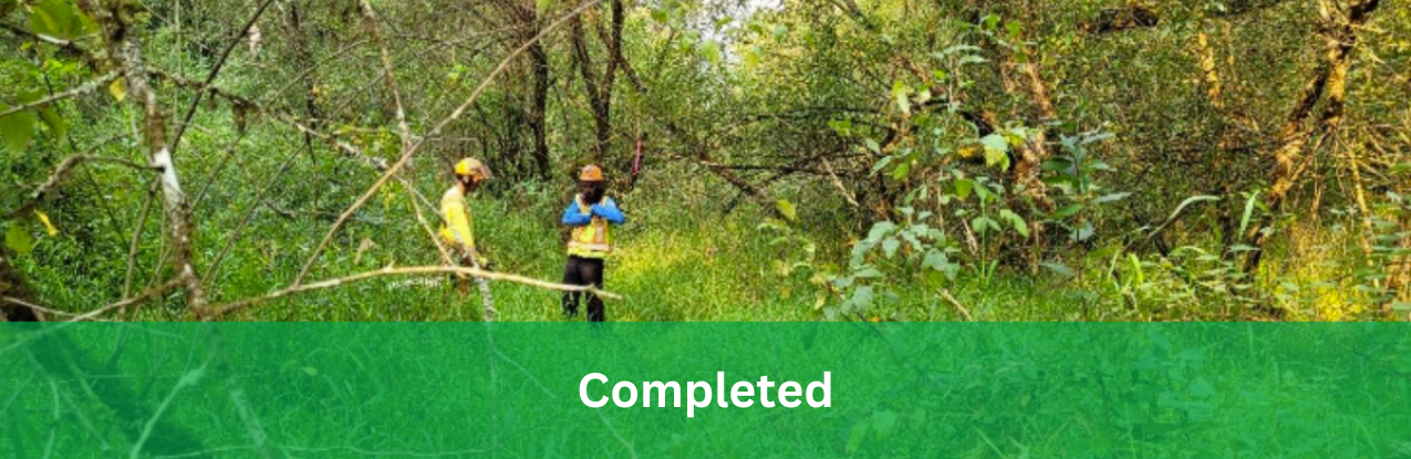
Qualified Professional (QP) Engineers assessed 133 affected waterway sites and 577 debris sites.
Task forces addressed sites where public safety risks were present. Task forces included representatives of First Nations, local authorities and private citizens. Task forces worked together on plans to remove hazards and restore affected watersheds.
Debris clean-up
Taskforces worked together on identification, collection and removal of various debris types.
Over 450 people from local communities and First Nations received specialized training. This work created 1,000+ employment opportunities.
An interactive debris map and reporting tool assisted in locating debris. This tool allowed citizens to report waterway debris. Once reported, the taskforces and qualified professionals would review and assess removal plans.
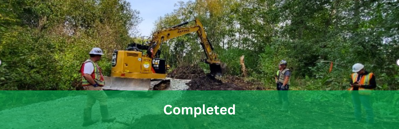
Debris removal projects occurred between March 2022 and January 31, 2023. Project teams removed over 16,000 metric tons of natural and human-made debris. Included in the debris was: 441 metric tons of metal, 98 vehicles and 4 bridges.

Review the final report StoryMap for the 2021 Atmospheric River debris clean up.
Water quality monitoring
A multi-agency provincial taskforce was created in response to concerns about water quality.
The water quality taskforce:
- Reviewed the initial water quality and potential risks from contaminants.
- Developed conceptual site models (CSMs).
- Completed human health and ecological risk assessments for the flood-impacted areas.
Assessments occurred in Sumas Prairie, Merritt, and Princeton.
The public can view the analysis on the Water Quality Monitoring Task Force Hub.
Sediment
The November 2021 ARE caused sediment movement, flooding and changes to B.C.'s river and creek systems. The sediment movement caused adverse impacts and extensive damage in some areas.
The Flood Debris Management program assessed sediment sites that posed risks to:
- public safety
- critical infrastructure
- environment
- culturally significant areas
Current work includes removing and relocating sediment from identified waterways.
News
FAQ for knotweed treatment in Hatzic Valley
Frequently Asked Questions
What is Knotweed and how does it spread?
Knotweed is a very aggressive invasive plant with a large, deep root system. In Hatzic Valley it has taken over drainage ditches, canals, sloughs, creeks, streams, and other areas. Knotweed has no natural predators in this region and can spread rapidly. Although it can spread by seed, it most commonly spreads through small plant pieces. Even tiny fragments can grow into new plants, allowing knotweed to spread quickly and crowd out other vegetation. Along waterways, broken pieces can float downstream and start new infestations.
In early spring, knotweed sprouts from its roots, and the new shoots look like red asparagus. It can grow extremely fast, up to 10 centimetres per day, and can reach about two metres tall in summer. After flowering in July or August, the plant begins to turn yellow as it prepares to go dormant. When frost arrives, the stems die back and dry out, but they remain standing through the winter. The plant then starts this growth cycle again the following spring.
àBC Government Knotweed information
What is a Pesticide Use Permit and why is it needed in Hatzic Valley?
The use of herbicides and pesticides in British Columbia is regulated under the Integrated Pest Management Act. Most pesticide use on private land does not require a permit, but applicators must still meet licensing and certification requirements. Chemicals are not allowed to be sprayed within one metre of a waterbody, the pesticide-free zone (PFZ) without special approvals.
Knotweed commonly grows along waterbody edges, riparian areas, and around waterbodies. To treat and eradicate this invasive species, a pesticide use permit (PUP) allows for special approvals to treat problematic species in sensitive areas. The permit will allow for the treatments at the proposed sites for a period of three years.
The Hatzic Valley has some historical knotweed disposal but has been mostly limited to roadside treatments. In addition, Electoral Area F is not part of the Fraser Valley Regional District Weed control program, Knot On My Property | Fraser Valley Invasive Species Society.
Where are the problematic treatment sites?
Under the Pesticide Use Permit (PUP) there are 64 sites to be treated in the Hatzic Valley. These site locations have knotweed plants growing in drainage culverts/ditches, along rivers and sloughs, and adjacent to creeks/streams where they have potential to cause lasting negative impacts.
When will treatment occur?
The best time to control the knotweed is while the plants are actively growing which allows herbicide to move through the plant into the roots. Treatments are anticipated to start August 1, 2026 and continue periodically until August 1, 2029.
There will be one or two treatments in late summer 2026, and subsequent treatments will be repeated at 6 to 8 week intervals as needed until the plants go dormant (October- November) following years the treatments will likely follow these windows: late May-June, August-September, and October-November.
Treatment timing will be adjusted to ensure that work is being done outside of the salmon spawning window and will consider when water levels are at their lowest during the dry part of the summer. All treated sites will be re-visited after treatment to monitor and assess the efficacy of initial treatments, and re-treated if necessary or possible.
How will Knotweed be managed in the Hatzic Valley?
To control knotweed, there are three methods of herbicide application that could be used: Stem injection, Foliar spray, and Wipe-on.
Selective herbicides are the best option and will use the following active ingredients as identified in the 2019 Herbicide Guidelines for Control of Knotweed Species on Crown Land:
- Imazapy and a surfactant blend or,
- Glyphosate
The herbicide glyphosate may be used as it is the only herbicide which is able to be applied via the stem injection method. This is a necessary application method as depositing the herbicide directly into the knotweed stems can eliminate the risk of pesticide drift away from the plant. Studies have also shown that glyphosate is non-persistent in soil and water, which means it does not stay active when it meets soil and water. Instead, it is degraded by microbial organisms (bacteria and fungi). This prevents leaching and uptake from other plants that did not have the herbicide applied onto it.
The herbicide application method chosen will be based on the site, and will depend on site conditions, such as proximity to walking foot-traffic, water, other infrastructure.
Foliar Spray:
- Herbicide is carefully applied onto the knotweed leaves using low flow backpack or hand-held sprayers and spray wands.
- Tarps will be used as herbicide drift shielding precaution to eliminate contact with either non-target vegetation or adjacent water.
Stem Injection:
- Herbicide is deposited directly into the hollow knotweed stems using hand-held injection devices. All stems of the plants will be injected, which requires the stems to be at least 0.5 inches for application to occur.
- Risk of pesticide drift should be eliminated due to depositing herbicide directly within the plant.
Wipe-On:
- Herbicide is wiped-on the leaves using wick applicators, which consist of an absorbent pad or brush device.
- Risk of pesticide drift should be eliminated due to depositing herbicide directly onto the plant.
Why does it have to be treated by herbicide?
Alternatives to treating knotweed with herbicide include taking no action, using a biological control or using a mechanical control. Currently there are no known biological controls. In comparison, mechanical controls for knotweed have been extensively studied. Although some studies have shown success with mechanical control, we believe the risks of prolonged treatment and fragmentation spread, outweigh the known success. With chemical controls, results are typically more than 80% dieback through initial herbicide treatments, and 100% eradication through subsequent treatments.
Cultural Exploration of The Sqwa:la (Hope Slough)
The Sqwa:la (Hope Slough) is in Chilliwack and is a historic water passage which connects Xwchíyò:m (Cheam), Sqwá (Skwah) and Shxwha:y (Skway) First Nations.

After the 2021 Atmospheric River Event, large amounts of sediment caused issues in parts of the Slough. Challenges included changes to water flow, access to the river and potential flooding to the area.
The Flood Debris Management Secretariat (FDMS) is working to improve channel capacity where Sqwa:la joins the Stó:lō (Fraser River). Improved channel capacity will decrease flood threat and will be helpful to the coho, chum, and several types of trout that travel up the slough each year to spawn.
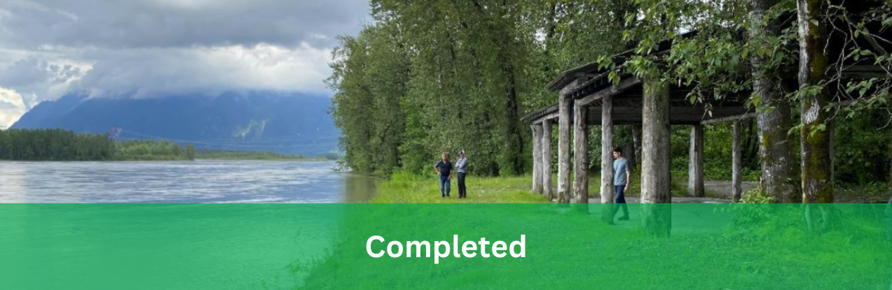
On April 5th, the Sqwa:la task force embarked on an 8km canoe journey to learn more about the Slough. Task force members for the journey included representation from FDMS, an authorizations specialist from the Ministry of Water, Land and Resource Stewardship, staff from the City of Chilliwack, Qualified Professionals who manage the project, and members from Xwchíyò:m and Sqwá First Nations. This trip was planned by the project leads and hosted by Xwchíyò:m and Sqwá First Nations to provide an opportunity to meet in person, see the project site and learn about the area’s history. The participants also experienced traditional Indigenous canoe journey protocols along the way.

As the group approached Kinsmen Park to stop for lunch, drums and singing was heard in the distance. When nearing the shore, paddles were raised to show the group came in peace. Elder Eddie Gardner, of Sqwá First Nation, led the canoe protocols. This included introducing the group, stating the intentions of the journey, and asking for permission to come ashore. The group was welcomed to shore by members from Shxwha:y Village and a feast was shared.

Along the way, the group stopped for a presentation on the water quality testing program happening throughout the Sqwa:la. Water quality testing is part of a separate restoration project, titled Shxwlistexw te Sqwá:la Shxweli: Care for the Life Spirit of the Hope Slough. Water quality in parts of the Slough has become an issue due to agricultural run-off and a slowing of water flow.
This event highlighted the importance and power of reconciliation through experiential learning. Participants were able to see firsthand how the Slough connected these communities and how issues such as flooding or reduced biodiversity impact the area. They were also able to witness and experience the traditions of the Indigenous Nations of the area. At the end of the journey participants shared reflections and offers of gratitude. It was a wonderful experience of sharing and learning between the project partners.
Flood Debris Management site tour
The Flood Debris Management Secretariat, from the Ministry of Environment and Climate Change, hosted a two-day tour of current project sites in the Fraser Valley that have ongoing recovery work from the November 2021 Atmospheric River Event (ARE).
The ARE caused substantial sediment movement, flooding and changes through B.C.'s river and creek systems, some of which caused adverse impacts and extensive damage.
Current work includes removing and relocating sediment from identified waterways which had potential to cause current or future issues to the surrounding areas.
This tour was an opportunity for teams from the Ministry of Water, Land and Resource Stewardship, and the Department of Fisheries and Oceans to meet the project teams and ask questions to gain clarification on recovery plans to assist with the permit and authorization process. Project teams were represented by members including: Leq'a:mel First Nation, Semá:th First Nation, Cheam First Nation, engineers, biologists, environmental groups and private land owners.

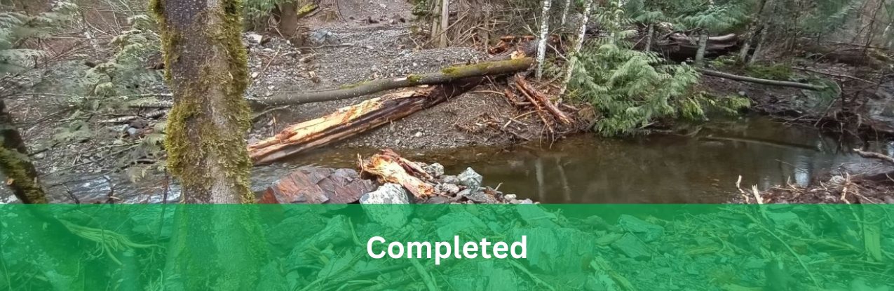
Image: tour participants hiked in the snow and rain to view the Slesse Park Landslide on the Chilliwack River.
 Image: Kilgard Creek showing low capacity in creek due to heavy sedimentation.
 Image: Hope Slough with active bank erosion
Willow whips find a new home
166 willow whip bundles harvested from the Hatzic Valley project were able to be rehomed. Approximately 110 bundles went to the Shxwlistexw te Sqwá:la Shxweli – Caring for the Life Spirit of the Hope Slough (Hope Slough project) and the remaining 56 bundles were donated to SAY Nations (Skowkale, Aitchelitz and Yakweakwioose), SAY will be using the willow for their 2km biodiversity and restoration project along the banks of Chilliwack creek (Old Chilliwack river).


Current projects
Learn more about current sediment projects happening in your area.
Services and information topics
Blue Creek

Area: Chilliwack
There was channel modification and flooding in the Blue Creek area. Sediment is being removed from the creek to re-establish pre-flood conditions. The project is planning to update parts of the area to current codes and standards.
Chawathil First Nation
Area: Chawathil First Nation outside Hope
Large amounts of sediment and woody debris accumulated at three sites in the area, which caused flooding of roads and houses. The remediation process involves removing the sediment, reconstructing existing culverts, and repairing stream banks to reestablish proper drainage.
Chemainus River

Area: Chemainus
Large accumulations of sediment was deposited along the Chemainus River.
Clayburn Creek

Area: Matsqui Prairie
The atmospheric river event caused erosion issues in the area. Sediment flowed downstream into the Matsqui Prairie plain which is next to Clayburn Village and agricultural lands.
Deroche Creek

Area: Chilliwack
Works at this site includes sediment removal to re-establish creek bed levels. A new channel is being created to redirect the creek toward a deeper section of the Nicomen Slough. This will divert flows away from Highway 7 to protect existing infrastructure.
Dzawada'enuxw (Kingcome Inlet)

Area: Kingcome
The Dzawada̱ʼenux̱w First Nation is an isolated community only accessible by boat and seaplane. Recovery works at this site includes the removal of sediment along the lower reaches of the river to improve water flow.
Grand Chief Douglas Memorial Building
Area: Cheam - Agassiz
Recovery works at this site include river bank restoration. This work will against future flooding events. The Province is also helping to maintain significant cultural sites. Traditional food gathering areas will also be maintained.
Hatzic Valley Emergency Works

Area: Hatzic - Mission
Works in the Hatzic Area include the removal of debris from waterways, culverts, bridge crossings and riverbanks. It also includes the restoration and repairing of eroded creek banks.
Hicks Creek
Area: Harrison Hot Springs
The project includes sediment removal at Hicks Creek following debris flow events along creek channels. Work included bank stabilization and hydraulic movement improvements. Project goal is to increase public safety while balancing the need to improve creek flow without negatively impacting the current habitat.
Hope Slough

Area: Chilliwack
Preliminary site assessment identified hydraulic capacity, access constraints and potential flooding concerns near the joining of Sqwa:la (Hope Slough) and Stó:lō (Fraser River) area west of Chilliwack, BC.
Kilgard Creek

Area: Sumas - Abbotsford
The atmospheric river event (ARE) resulted in large accumulations of sediment being deposited along the full length of the creek. Emergency works include the removal of sediment in and around the culvert crossings.
Lorenzetta Creek

Area: Outside Hope
Work will include repairing banks and restoring channel capacity.
Merritt

Area: Merritt
Houses along Fir Street in the City of Merritt are at risk from an eroding slope on the Coldwater River.
Musqueam Creek
Area: Musqueam First Nation
Works at this site include riverbank recovery, stabilization, and protection against future flooding events.
Slesse and Ranger Slides

Area: Chilliwack
Due to the scale of these two landslide sites, geotechnical assessments were necessary to evaluate the stability of the area, comment on the probability of a large volume slide in the future, and explore potential impacts of future flooding events.
Sumas River and Canal

Area: Sumas - Abbotsford
The atmospheric river event caused substantial damage along the Sumas River. Recovery works include the removal of sediment from the river and canal channels, the repairing of existing riverbanks, and erosion protections.
Vedder River and Canal

Area: Yarrow - Chilliwack
The atmospheric river event (ARE) resulted in large accumulations of sediment deposition along the Vedder Canal and River. Recovery works involve the removal of this sediment to improve river flow and repair riverbanks from the ARE.
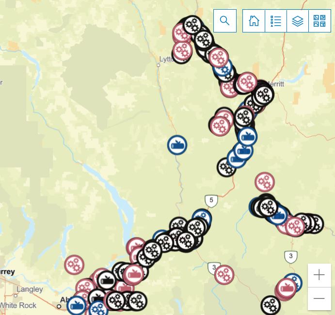
This interactive debris map shows real-time location and debris removal caused by the Atmospheric River Event (ARE).
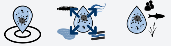
This interactive hub provides resources and tools to aid in the assessment of environmental contamination caused by the British Columbia atmospheric river events of 2021.
 Flood Debris Management Secretariat FAQ [PDF, 411KB]
Contact information
sec.info.epd@gov.bc.ca