
Chemainus River

Area: Chemainus
Large accumulations of sediment was deposited along the Chemainus River.
Recovery works include:
- removal of sediment to re-establish the channel capacity
- construct a temporary flood protection barrier wall to increase public safety
- design and construct bank protection downstream of the highway 1 bridge
The Chemainus River is a salmon -bearing stream found on the east coast of Vancouver Island. Its estuary is located approximately 10km north of the City of Duncan. The watershed has an area of about 360km2 and the main stem of the river is approximately 64km long.
Project Details
Total Budget:
$5.9 Million
Projected Completion Dates:
- Sediment removal: Complete
- Flood barrier wall: Complete
- Bank protection: December 2024
Community & Taskforce Members
- North Cowichan Regional District
- Halalt First Nation
- Penelakut First Nation
- Ministry of Emergency Management and Climate Readiness
- Ministry of Environment and Climate Change Strategy
- Ministry of Forests
- Indigenous Services Canada
- Parsons Corporation
- Stone Pacific Contracting Ltd.
- Kerr Wood Leidal
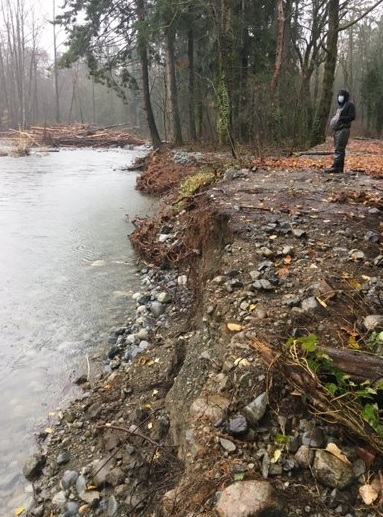
Images

Above image: Bank protection bendway weirs. September 2024
Risk Evaluation
Public Health and Safety
Ongoing accumulation of sediment on the left bank and erosion of the right bank is likely. This increases the potential for more overbank flows onto the right bank floodplain.
The berm construction on the floodplain could increase the potential for erosion. The risk to public health and safety at Site 1 is considered medium in comparison to the flood risk the community faces which is high.
Build-up of sediment between the railway bridge and Chemainus River Bridge reduces flow in the channel. This could result in more overbank flow in the Butcher Slough and across the right bank floodplain. The extra flow could lead to a moderate degree of increased flood levels across Chemainus Road, and within the Tsussie FN community. There is moderate incremental risk to public health and safety
River Capacity
Build-up of debris on the left bank point bar and side channel has reduced river capacity. The debris build-up increases potential for bank erosion on the right bank and partial erosion to side channels. Due to gravel sources upstream and the erodible material on the right bank, the developing risk to river capacity is high.
Ongoing build-up of sediment between the E&N Railway Bridge and Chemainus River Bridge will continue to reduce flow in the channel. which could result in flow in the Butcher Slough and across the right bank floodplain.
The riverbanks in this area are protected from erosion by bedrock and riprap. Sediment accumulation has limited potential for triggering further bank erosion or channel avulsion.
Environmental
Avulsion of the flow into the side channel could result in loss of the existing 1.6 km of area that provides habitat. The upstream end of the side channel is set back from the mainstem and this limits the potential for a partial or full avulsion. The berm construction could concentrate flow in the relic side channel and increase the potential for avulsion. The avulsion is likely and the incremental risk to environment is medium.
Build-up of sediment in this area of the river has promoted growth of vegetation and collection of wood debris which provides complexity to habitat in this area. The incremental risk to environment is low.
Infrastructure
The potential for erosion of the right bank is high. There is moderate likelihood of avulsion into side channel. Infrastructure within Halalt FN are set back (300 m to 500 m) from both the mainstem and relic side channel. The potential for impact to infrastructure as a result of bank erosion or channel avulsion is low within Halalt FN.
Past wood debris on the E&N bridge and Chemainus River bridge show that these structures are susceptible to debris accumulation. Recent removal of debris from these bridges has reduced the risk of impacting infrastructure. Ongoing monitoring will be required to assess accumulation of debris at these bridges.
Project Links
Contact information
sec.info.epd@gov.bc.ca
Subscribe
Enter your email address to subscribe to updates of this page.