Merritt
Area: Merritt
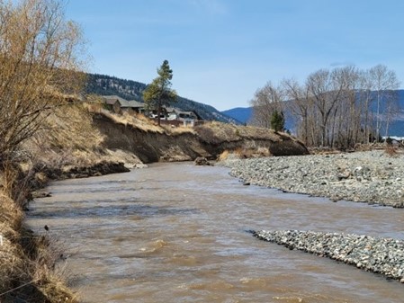
Houses along Fir Street in the City of Merritt are at risk from an eroding slope on the Coldwater River.
The site is located within the City of Merritt, approximately 200 m downstream of Merritt Voght Street bridge (Middlesboro Bridge), on the left bank of the Coldwater River. During the November 2021 ARE, the Coldwater River flooded. The Voght Street bridge collapsed immediately upstream of the project area. Adjacent to the site, the river previously meandered along the right bank dike, and during the ARE flood the meander filled with sediment causing a channel avulsion to cut through the meander. At the site, the thalweg was pushed to the base of the steep clay cliffs at the site which increased the risk of bank destabilization. Downstream of the site, there were sections where the left and right bank dikes failed.
Works to mitigate erosion and flooding risks along a reach of the Coldwater River in Merritt, BC will address erosion and bank stability caused by the November 2021 ARE. The objective is to implement erosion protection that would protect the site from further erosion and land loss due to the Coldwater River.
Project Details
Total Budget:
$9.4 Million
Projected Completion Date:
December 2025
Community & Taskforce Members
Images

Risk Evaluation
Public Health and Safety
Flooding, scour and rainfall will continue to undermine and erode the outer bank cliff. This will increase the risk to the residents on Fir Ave.
River Capacity
Bank failure, channel avulsion and sediment deposition are expected to reduce channel capacity, at least for a temporary duration, and create additional risks to upstream and downstream areas.
Environmental
Bank failure would result in deposition of fine grained material which is expected to negatively impact fish habitat. Channel avulsion and sediment deposition would impact vegetation along the river, however, we anticipate that the vegetation would re-establish on its own.
Infrastructure
High river flows, scour and rainfall will continue to undermine and erode the outer bank cliff. This will increase the risk to the houses on Fir Ave.
Contact information
sec.info.epd@gov.bc.ca
Subscribe
Enter your email address to subscribe to updates of this page.

