
Kilgard Creek

Area: Sumas - Abbotsford
The atmospheric river event (ARE) resulted in large accumulations of sediment being deposited along the full length of the creek. Emergency works include the removal of sediment in and around the culvert crossings.
Kilgard Creek flows roughly north to south in the vicinity of Sumas Mountain Road and is a tributary of Marshall Creek which discharges to the Sumas River. The upper watershed of Kilgard Creek drains part of Sumas Mountain and it is a steep mountain creek. Some 200 meters north of Kilgard Road, Kilgard Creek’s gradient flattens somewhat into a sediment deposition zone and the lower watershed is located within the lowlands of the Marshall Creek watershed, mostly on Semá:th First Nation (SFN) reserve lands within Upper Sumas IR 6.
Lower Kilgard Creek was subject to significant sediment deposition and flooding during the November 2021 ARE. The sediment deposition significantly reduced the flow capacity of the creek channel and three driveway culvert crossings. Minor rainfall-runoff events were no longer contained in the creek channel, creating a flood risk to nearby SFN lands that impacted buildings, access roads, and the surrounding areas.
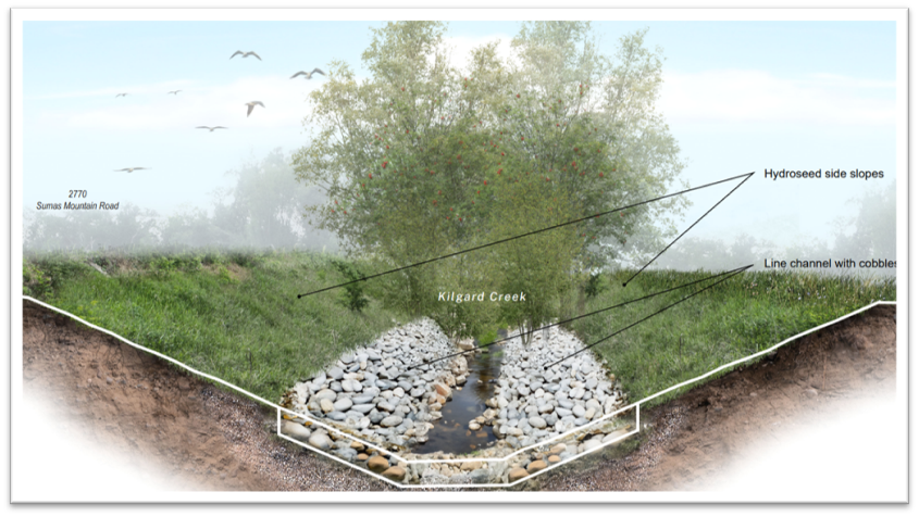
Recovery work includes replacement of creek crossing structures and bank erosion protection. See below suggested rendering.
Project Details
Total Budget:
$4.8 Million
Projected Completion Date:
November 2024
Community & Taskforce Members
- Sumas First Nation
- Indigenous Services Canada
- Fisheries and Oceans Canada
- Ministry of Environment and Climate Change Strategy
- Ministry of Forests
- Ministry of Emergency Management and Climate Readiness
- Kerr Wood Leidal
- Lil Bear Contracting Corp
Videos
Images
 Image above: Previous location of "Culvert three" after January 2024 rain and snow melt.
 Image above: Showing high capacity of culvert at a road crossing.
 Image above: Removing the left culvert
 Image above: Bank showing erosion and exposed tree roots.
 Image above: Showing culvert upstream and fish ladder.
 Image above: After culvert was removed in November.
Risk Evaluation
Public Health and Safety
Potential flooding due to blocked culverts could pose a hazard to members of the public who use Sumas Mountain Road, the two local access roads, and the nearby buildings.
River Capacity
Kilgard Creek high flows are governed by fall/winter rainfall events, not freshet. However, overbank flooding of Kilgard Creek is occurring during minor rainfall events due to the sediment deposition within the creek channel. Further overland flooding could also occur under higher flows due to the sediment blocking the access road culverts and reducing their capacity.
Environmental
Damage to surrounding vegetation resulting from flooding.
Infrastructure
Due to the sediment accumulation within the two culvert crossings, the two access roads, Sumas Mountain Road, and nearby buildings, including the Sumas Nation Administration Office, Health Building, and School, are at an increased risk of flooding. Since the sediment deposition, one residence has already reported flooding during rain events.
Contact information
sec.info.epd@gov.bc.ca
Subscribe
Enter your email address to subscribe to updates of this page.