Learn about caribou in British Columbia
Herds of caribou have roamed British Columbia for thousands of years contributing to the province’s rich biodiversity and ecosystems.
On this page
Types of caribou
Caribou are a true northern species that thrive in cold and harsh landscapes. They depend on large, undisturbed areas for food resources, reproductive success, and protection from predators and the weather. Indigenous peoples know caribou by many different names that reflect the different ecotypes of caribou, as well as the diversity of Indigenous languages. The Committee on the Status of Endangered Wildlife in Canada (COSEWIC) has assigned caribou into 12 “designatable units” (DUs) based on genetics, appearance, behaviour, and distribution. The federal Species at Risk Act (SARA) recognizes three sub-species, with multiple populations formally listed as “species” for the purpose of the act:
- Rangifer tarandus pearyi (found only on arctic islands)
- Rangifer tarandus groenlandicus (found on tundra)
- Rangifer tarandus caribou (found in forests)
Caribou in British Columbia are Rangifer tarandus caribou and are comprised of 54 subpopulations (herds). Generally, herds are grouped by “ecotype”, based on habitat use and behaviours. Further classification differs between SARA and COSEWIC, as outlined in the following table:
| Ecotype | SARA listed species | Group (SARA) | Designatable unit (COSEWIC) |
|---|---|---|---|
| Mountain ecotype | Southern Mountain population | Southern Group | Southern Mountain DU9 |
| Northern ecotype | Central Group | Central Mountain DU8 | |
| Northern Group | Northern Mountain DU7 | ||
| Northern Mountain population | Northern Mountain population | ||
| Boreal ecotype | Boreal population | Boreal population | Boreal DU6 |
Boreal caribou
The boreal caribou ecotype occurs throughout boreal (northern) forests from Alaska to Newfoundland. This ecotype is the least common of the three caribou ecotypes found in British Columbia. Boreal caribou occupy five herd range areas in the northeast portion of the province and their range is continuous with those in Alberta and the Northwest Territories.
Boreal caribou depend on large, undisturbed areas for food resources, reproductive success, and protection from predators and the weather. They primarily use large peatlands and open, old forests throughout the year. These caribou are listed as “threatened” under SARA, are provincially red-listed (threatened to endangered), and are identified as a Priority 1 species under the B.C. Conservation Framework.
Northern Mountain caribou
The Northern Mountain caribou ecotype occurs throughout the mountainous regions of north-central and northwestern B.C. and is the most common of the three caribou ecotypes found in this province. These caribou occupy 17 herd range areas and their range extends to Yukon and the Northwest Territories.
Northern Mountain caribou depend on large, undisturbed areas for food resources, reproductive success, and protection from predators and the weather. They spend the summer primarily on alpine and upper subalpine ranges. In winter, some herds move down to coniferous forests and lower subalpine areas, although other herds spend the winter in alpine areas. These caribou are listed as a “special concern” under SARA, are provincially blue-listed (at risk, but not extirpated, endangered, or threatened), and are identified as a Priority 2 species under the B.C. Conservation Framework.
Southern Mountain caribou
The Southern Mountain caribou (SMC) ecotype is within world's southernmost caribou population. Historic ranges extended as far south as northern Idaho and Washington. This ecotype is divided into three groups, based on the “designatable” units defined by COSEWIC:
- Northern Group (DU7) with 9 herd range areas
- Central Group (DU8) with 5 herd range areas
- Southern Group (DU9) with 18 herd range areas
Southern Group herds live in the interior wet belt. In winter, these caribou can walk on top of deep snowpack and feed on arboreal lichens (lichens that grow on trees). Most of these caribou remain at mid to high elevations year-round, but some herds move to lower elevations seasonally. They spend some of the winter in low-elevation pine forests feeding on terrestrial lichens and spend other portions of the winter in subalpine areas in high-elevation ranges, feeding on arboreal lichens or on terrestrial lichens found on wind-swept, alpine slopes.
Southern Mountain caribou depend on large, undisturbed areas of primarily mountainous terrain for food resources, reproductive success, and protection from predators and the weather. These caribou are listed as “threatened” under SARA, are provincially red-listed (threatened to endangered), and are identified as a Priority 2 species under the B.C. Conservation Framework.
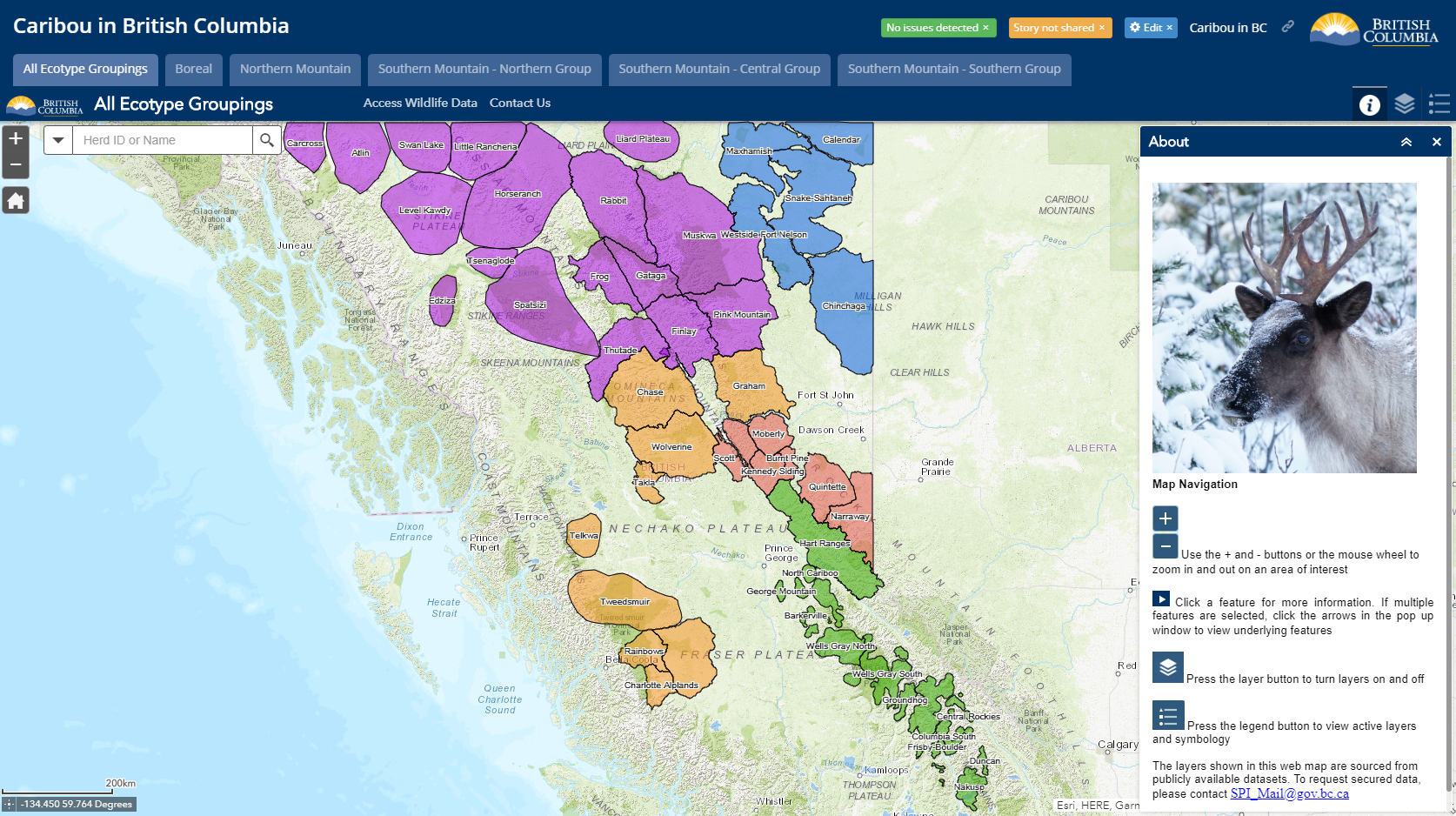
To see where these caribou groups are located, view the interactive map Caribou in British Columbia.
Physiology
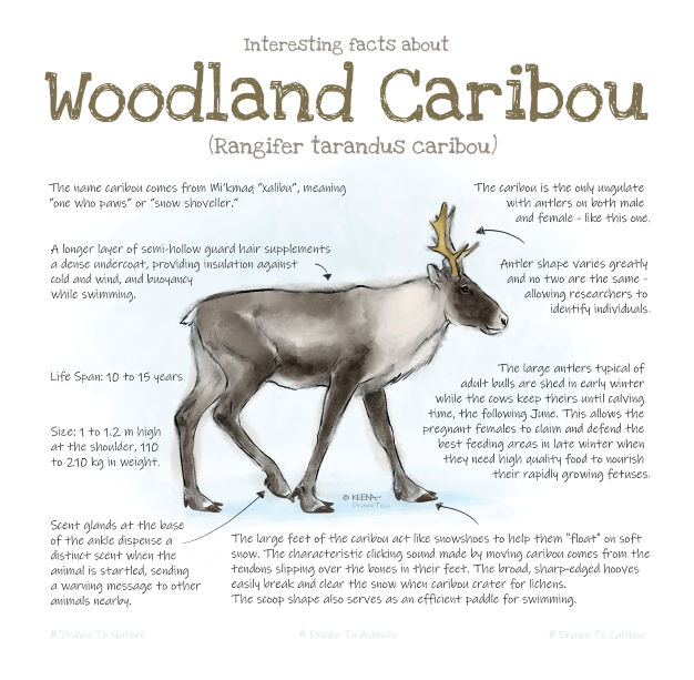
Caribou are part of the deer family. They are larger than deer, but smaller than elk and moose. They are usually medium to light brown, with shades of grey, and white on their rumps and necks. Both males and females grow antlers, with males losing theirs in early winter and females retaining theirs until their calves are born in spring. Caribou hooves are large and rounded, which helps them dig through snow to reach food (terrestrial lichens) and allows them to walk on top of the snowpack when feeding on lichens that grow on trees (arboreal lichens).
Population
Under SARA, all listed caribou populations in Canada are identified as needing special management actions because of their declining populations. In B.C., this decline may be attributed to:
- Habitat loss and displacement
- Habitat fragmentation and alteration
- Habitat avoidance and displacement caused by recreational activities (e.g., snowmobiling)
- Mortality caused by predation
- Mortality associated with human activities (e.g., vehicle collisions)
The B.C. government is committed to conserving caribou by implementing management measures through the Provincial Caribou Recovery Program.
Population estimates: Surveys of most of the 54 caribou herds in British Columbia have been conducted for decades to better understand their status and estimate population size and trends. Survey techniques and methods may differ based on the geographic area, weather conditions, time of year and other factors.
Habitat
Generally speaking, caribou habitat is the landscape where these animals forage, calve, migrate, and breed (“core” habitat), as well as the surrounding area that influences their activities throughout the year (“matrix” habitat).
Core habitat
Core habitat is the annual range for a specific subpopulation of caribou. This area has or may have attributes needed to support self-sustaining caribou populations. Core habitat is mapped at a broad scale and therefore may include areas not generally considered to be caribou habitat, such as high-elevation rock and ice. Core habitat may be further divided into some or all of the following four categories:
- High-elevation winter range (HEWR)
This range includes windswept alpine ridges and adjacent subalpine forest. High-value areas in HEWR include alpine, subalpine parkland, and mature high-elevation subalpine forests - High-elevation summer range (HESR)
This range includes alpine and subalpine areas used by caribou for calving and summer range, with many areas also serving as HEWR. High-value areas in HESR include alpine, subalpine parkland, and mature high-elevation subalpine forests - Low-elevation winter range (LEWR)
This range includes low-elevation forest types (e.g., pine, black spruce, tamarack stands of trees) used by select caribou herds in the winter - Low-elevation summer range (LESR)
This range is used during the spring calving, summer, and fall/rut periods in low-elevation mature forests (e.g., pine, black spruce, tamarack stands of trees) by select caribou herds
Matrix habitat
Areas adjacent to core caribou habitat may only be used by the animals periodically or infrequently, but these areas may still be important because they connect core habitats. Most importantly, when matrix habitat is altered, these areas then support higher densities of other ungulates (e.g., deer) that lead to increased numbers of their associated predators (e.g., wolves). This results in unsustainable predation pressure on caribou. Matrix habitat includes areas within 30 kilometres of core caribou habitat and is determined based on winter range of primary prey, local knowledge of predator distribution, and barriers to predator movement. Matrix habitat boundaries may also be defined by landscape features (e.g., large water bodies, glaciers, human settlement).
Legislative tools
Legislative tools are available to land managers to support habitat conservation and caribou recovery. These tools fall under the Land Act, the Forest and Range Practices Act, and the Oil and Gas Activities Act, and under the Environmental Protection and Management Regulation for petroleum and natural gas activities.
Land Act
The Land Act Reserves (Section 16 and Section 17) are tools that are used to identify a formal conservation interest. For caribou, these tools would be used for the conservation of wildlife habitat. Section 16 is used for a temporary withdrawal of Crown land for other uses, and Section 17 is used for a conditional withdrawal of Crown land for a designated use (e.g., setting aside Crown land for caribou recovery).
Forest and Range Practices Act
The Forest & Range Practices Act (FRPA) governs forest and range activities on public lands in B.C. related to forest planning, roadbuilding, timber harvesting, reforestation and livestock grazing.
Petroleum and natural gas activities
- Oil and Gas Activities Act (OGAA)
- Wildlife and Wildlife Habitat Management under OGAA and EPMR (PDF, 530KB)
Spatial resources for habitat management
- Search iMapBC for the location of coal land reserves or resource review areas (RRAs). Go to “Data Sources”, then “Add Provincial Layers”, and then search for coal land reserves or resource review areas. Click on the layers that you want to show up on the map, and then zoom in to review.
- Approved Ungulate Winter Ranges
- Approved Wildlife Habitat Areas
- Wildlife Habitat Areas and Ungulate Winter Range Map (PDF, 350KB)
- Old Growth Management Areas (legal, current)
Habitat mapping
Caribou herd boundaries are shown on an interactive map at Caribou in B.C. and here Access to spatial data (gdb.zip) and metadata.
For many Southern Mountain caribou herds in the Southern Group, refined mapping techniques have been used to identify core and matrix habitats. This provides greater accuracy than the critical habitat mapping completed for the 2014 federal Recovery Strategy for the Woodland Caribou, Southern Mountain population in Canada (PDF, 10.1MB) and it supports better caribou recovery planning. These maps are currently being reviewed and will be released soon. Further core and matrix habitat mapping is underway for the Central Group, Northern Group and Boreal herds. The maps may be adjusted and refined as new science and knowledge becomes available.


