
Kamloops Land & Resource Management Plan
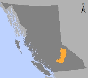
The Kamloops Land and Resource Management Plan (LRMP) is a sub-regional land use plan covering 2.2 million hectares of south-central B.C. It is the result of a two-year shared decision-making process that involved about forty public and government representatives. The B.C. government approved the plan recommendation and published the plan in 1995.
The Kamloops LRMP provides management objectives and strategies for:
- Land Management
- Water management
- Riparian management
- Ecosystem management and biodiversity
- Grasslands management
- Inland and anadronomous fisheries
- Range
- Recreation and tourism
- Minerals
- Wildlife, critical deer winter range and critical moose winter range
- Timber
- Visually sensitive areas
- Cultural and heritage sites and trails
- Settlement resource management zones
- Protection resource management zones
- Special resource management zones including community watersheds, habitat/wildlife management areas and recreation/tourism
Legal Direction & Maps
- Kamloops LRMP Higher Level Plan Order and Subsequent Amendments - 2013 (PDF, 32 MB)
- Order Establishing OGMA Objectives in the Kamloops LRMP Area - 2013 (PDF, 32.7MB)
- Order Amending Kamloops LRMP: Cancelling Old Growth Attribute Objectives - 2013 (PDF)
- Order Amending Kamloops LRMP: Cancelling Caribou Management Objectives - 2009 (PDF, 3.8MB)
- Order Amending Kamloops Higher Level Plan / Kamloops LRMP Order: Implementation of the Kamloops LRMP in the Context of FRPA - 2006 (PDF)
- Order Amending the January 23, 1996 High Level Plan of the LRMP - 1996 (PDF, 3.9MB)
- Order Declaring Kamloops LRMP to be a Higher Level Plan Under Forest Practices Code - 1996 (PDF)
Implementation & Monitoring Direction
Plan Type: Land and Resource Management Plan
Plan Status: Approved, legally established
Plan Area: 2,769,417 hectares
Natural Resource Region: Thompson/Okanagan
Natural Resource District: Thompson Rivers
Timber Supply Area: Kamloops
Contact information
Contact us if you have questions about land and resource management in the Thompson / Okanagan region.
TOR.LUP@gov.bc.ca