
Community Watersheds
The majority of British Columbians get their drinking water from surface water. These sources range from small streams to large reservoirs. Community watersheds play an important part in protecting water quality for communities and private water users that rely on surface water sources.
A community watershed is defined under the Forest & Range Practices Act (FRPA) as all or part of the drainage area that is upslope of the lowest point from which water is diverted for human consumption by a licensed waterworks. Community watersheds must also be designated under the Government Actions Regulation.
To protect the water that is diverted for human consumption, such areas require special management to:
- Conserve the quality, quantity and timing of water flow
- Prevent cumulative hydrological effects having a material adverse effect on water
There are currently 466 designated community watersheds in B.C. with most established in the 1980s and 1990s. Establishing community watersheds is one of the ways the Provincial Government protects drinking water sources.
Locating Community Watersheds
Find a community watershed and learn more about its features:
Community watershed data is captured daily. Private land values are a best approximation. Further help for using the query tool is provided below.
Instructions for Running a Query
The check boxes and search criteria boxes on the query page enable the user to search for specific information.
To find information about a community watershed, type into one or more search fields. Only one entry field needs to be completed and no fields are mandatory. The fields are not case sensitive.
The results of the query can be exported to a spreadsheet or database by selecting the Data Output/Export option. From the results screen, save the data as a text file.
Many applications recognize the CSV extension as being a comma delimited file. Data elements are separated by commas and Records are separated by carriage returns.
Try viewing the document source through the Browsers View menu.
Technical Notes for the Query Tool
The data query works best with an internet browser that supports tables and forms.
Duplicate community watershed names may appear throughout the province. Note the forest district/region and Point of Diversion to confirm the location.
The more information typed into a field, the more precise the search. For example, typing "100" in the Community Watershed Code field will return all community watersheds beginning with 100, while typing "100.054" will return information on the community watershed 100.054.
Entering data into more fields increases the precision of the query. For example, typing "100" in the Community Watershed Code field and typing "9-Aug-96" in the Date field will return only those watersheds with a Community Watershed Code beginning with 100 and have a Designated Date greater than or equal to August 9th, 1996.
To select/deselect specific columns of information for output, simply click on the box to the left of each of the input field names.
Terms & Definitions
CWS Type: Based on tenure and indicates if the watershed is a community watershed based on the FRPA or if it is defined only by the B.C. Ministry of Environment.
Date Designated: Allows the user to find community watersheds that were designed between specific dates.
Community Watershed Code: A three-digit, three decimal point number (e.g., 000.000) referencing a specific watershed. The first three digits represent the major watershed code numbers. The last three digits have been arbitrarily assigned.
Community Watershed Name: The name of the community watershed, which is usually the same as the stream name.
Forest District Code: A three-digit code assigned to each forest district.
Forest District Name: The name of the forest district (e.g., Chilliwack).
Forest Region Code: A three-digit code assigned to each forest region.
Forest Region Name: The name of the forest region (e.g., Vancouver).
TRIM Mapsheet: The 1:20,000 TRIM map on which Point of Diversion for the community watershed is located.
Points Code: The point at which water is withdrawn from the stream and is the lowermost point that defined the boundary of the community watershed.
Source Type: Indicates whether the watershed is sourced by a stream, creek, lake or other source.
Source Name: The source name is the name of the stream, creek, or lake after which the community watershed is usually named. Typically the source name and the name of the community watershed will be the same.
Count the number of watersheds: Provides the user with the exact number of watersheds in the query.
Calculate the total hectares: Calculates the sum of the total hectares of all community watersheds selected.
Display watershed map: Shows a small-scale map of the watershed, the total hectares and Point of Diversion.
Contact Name: Lists the person who should be notified of any work or activity proposed within the watershed.
Watershed Assessment Complete: Indicates that a watershed assessment, as required under the FRPA, has been completed.
Watershed Assessment Date: The last date that a watershed assessment was completed.
Watershed Assessment Author: The name of the person or contractor who conducted the assessment.
Show watersheds: Allows the user to find all Active, Absorbed (community watersheds that were absorbed into larger community watersheds that were designated at a later date) and Cancelled community watersheds, or combinations thereof.
Governance
The Forest & Range Practices Act (FRPA) addresses forest companies and rancher operations on the Crown land portion of community watersheds to protect water used for drinking. The Act sets out requirements for various activities, such as road-building or harvesting, within community watersheds.
The B.C. Government reviews and approves Forest Stewardship Plans for companies operating in community watersheds. Under the FRPA, community watersheds restrict only the activities of forest and range tenure holders.
History
Community watersheds were first defined by the Guidelines for Watershed Management of Crown Lands Used as Community Water Supplies in 1980. In the 1990s, the guidelines were expanded and updated to protect drinking water in community watersheds from the impacts of multiple resource use such as logging, road building, recreation and agriculture.
The community watershed guidelines, along with 429 community watersheds that met the original 1980 criteria, were grandparented into the Forest Practices Code of British Columbia Act in 1995, which was later replaced by FRPA in 2004.
In 2014, the independent B.C. Forest Practices Board released results and recommendations (PDF) of a special investigation into the community watershed program. The Provincial Government has made a commitment to respond to these recommendations.
Watershed Restoration Program: From 1994 to 2004, this program worked to improve water quality and fish habitats that were impacted by past forest harvesting practices.
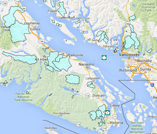
See where community watersheds currently exist in British Columbia:
View information related to the water resources of British Columbia, such as watersheds, water quantity and quality monitoring sites, aquifers, water wells and flood protection works.
Regulations
The Forest Practices Board serves the public interest as the independent watchdog for sound forest and range practices in British Columbia.