
Mineral Titles: Recreational hand panning
We acknowledge the territories of First Nations around B.C. that share their traditional and unceded territories with us. We acknowledge the rights, interests, priorities and concerns of all Indigenous Peoples (First Nations, Métis and Inuit), respecting and acknowledging their distinct cultures, histories, rights, laws and governments.
What you need to know:
- Free Miner Certificate not required
- Only a hand pan and shovel allowed (no metal detectors, sluice boxes, suction dredges or other devices)
On this page
- What is hand panning?
- Where not to hand pan
- Where can a person hand pan
- Equipment you can use
- Best practices when hand panning
- Recreational hand panning reserves web app
What is hand panning?
Hand panning is defined as:
Washing earth, sand and gravel in a hand pan to separate loose minerals. Also known as panning or gold panning.
Where not to hand pan
Hand panning is prohibited on a Provincial heritage site.
A person has no right to explore for minerals or placer minerals on federal land, treaty settlement lands, Indian reservations, parks, conservancies, ecological reserves or protected areas.
Where can a person hand pan
Recreational panning reserves
Hand panning is allowed in a recreational panning reserve.
Individual Panning Reserve Information
|
Site Name |
Site Number (MTO Site Details) |
Mapsheet Number (PDF Location Map) |
GPX Files (To be used with a GPS)* |
|
Barnes Creek |
082E (PDF, 712KB) |
Waypoints and Tracks | |
|
Cayoosh Creek |
092I (PDF, 916KB) |
Waypoints and Tracks | |
|
Erickson |
082F (PDF, 765KB) |
Waypoints and Tracks | |
|
Goldstream River |
082M (PDF, 689KB) |
Waypoints and Tracks | |
|
Hope |
092H (PDF, 752KB) |
Waypoints and Tracks | |
|
Kennedy River |
092F (PDF, 739KB) |
Waypoints and Tracks | |
|
Kettle River |
082L (PDF, 756KB) |
Waypoints and Tracks | |
|
Lytton (Site 1) |
092I (PDF, 918KB) |
Waypoints and Tracks | |
|
Lytton (Site 2) |
092I (PDF, 871KB) |
Waypoints and Tracks | |
|
Princeton |
092H (PDF, 1209KB) |
Waypoints and Tracks | |
|
Quesnel-Fraser River Junction |
093B (PDF, 824KB) |
Waypoints and Tracks | |
|
Spruce Creek |
104N (PDF, 666KB) |
Waypoints and Tracks | |
|
Wild Horse River |
082G (PDF, 960KB) |
Waypoints and Tracks | |
|
Yale Town |
092H (PDF, 557KB) |
Waypoints and Tracks |
*GPX (the GPS exchange format) is a light-weight xml data format for the interchange of GPS data (waypoints, routes, and tracks) between applications and web services on the internet. Source
Downloading the GPX Waypoints and Tracks based on browser:
- Edge: right-click on the Waypoints and Tracks link and select Save Target As
- Chrome: click on the Waypoints and Tracks link and a pop-up offering to Open or Save the GPX file will appear.
- Firefox: - click on the Waypoints and Tracks link and a pop-up offering to Open or Save the GPX file will appear.
- Mac/Safari: - Simply click on the Waypoints and Tracks link and the file will automatically download to your computer.
KML File - Google Earth
Using Google Earth this KML file will automatically open and zoom to British Columbia adding the BC Recreational Panning Reserves to your Temporary Places folder.
Panning with permission
Hand panning requires permission on the following areas:
| Area of interest | Who to contact for permission |
|---|---|
| claim or lease, mineral or placer | recorded holder of the mineral title |
| private property | property owner |
Equipment you can use
Limited to the following tools:
- hand pan
- hand shovel
Does not include the use of:
- a metal detector - using a metal detector is a prospecting activity*
- sluice or shaker boxes, suction dredges, and other mechanical devices
*Section 11(1) of the Mineral Tenure Act requires that only a free miner or an agent of a free miner may enter mineral lands to explore for minerals or placer minerals, which includes prospecting for minerals or placer minerals with a metal detector.
Best practices when hand panning
We all have a role to play in protecting the environment. Please see below for best practices to follow when hand panning. Print a two-page summary (PDF, 579KB) of best practices to take out to the field.
All human activity has the potential to impact fish and wildlife and their habitats. Riparian areas (stream sides and shorelines) provide critical habitat for fish, wildlife, amphibians and birds. Plants growing along streams provide food, shelter and nesting sites and protect stream environments for fish.
Do:
-
Observe wildlife from a distance
-
Leave dead woody logs and material in place
-
Use existing trails or paths
-
Pack out your garbage – follow Leave No Trace practices
-
Report any concerns about suspected violations of fisheries, wildlife, or environmental protection laws anonymously – RAPP 1-877-952-RAPP (7277) or online
Do Not:
-
Disturb or remove vegetation
-
Dig into stream banks slopes
-
Feed wildlife
-
Disturb beaver dams, nests or wildlife dens
All British Columbians have a role to play in protecting water resources and fish habitat.
Do:
- Prevent the release of fine sediment or other substances into streams. (Studies have shown that the introduction of fine sediments directly from digging activity in the stream and indirectly from run-off from exposed soils has severe negative impacts on all life stages of fish and other aquatic life and their habitat. )
- When digging for material to pan, store the material and use the same material to fill in the hole before the end of day. ALWAYS fill in your holes after panning. Leaving holes can trap fish as water levels rise and fall and can create safety hazards for other users.
Do Not:
- Remove gravels from streambeds – spawning salmon scoop out a hollow, called a redd, in the gravel of a streambed to deposit their eggs.
-
Introduce other material into streams such as human waste, garbage, wood/burned debris or any manmade substances.
-
Divert water by making channels
Invasive species threaten many of our social, cultural, environmental, and economic values. Invasive species cost the global economy billions of dollars every year. They are a top threat to biodiversity, impact culturally and socially important areas, and can threaten human health in various ways, including through stings, burns, or poisonings.
Do:
- Clean, drain, and dry all equipment after use when working or recreating around freshwater lakes, streams, and wetlands to prevent transport of invasive species. For more information see PlayCleanGo
Do Not:
- Remove gravels for processing at another location. Do not take gravel or other materials from one site to another.
Although many gold panning reserves are located near communities, there are safety hazards that you may encounter when enjoying the outdoors in BC. Below are a few to consider:
-
Before heading out, know the location of current wildfire activity, fire bans or restrictions - https://www2.gov.bc.ca/gov/content/safety/wildfire-status
-
If you see a wildfire, report it as soon as possible. Call 1-800-663-5555, or *5555 on a cell.
-
Check DriveBC to check for any travel restrictions.
-
Avoid panning near streams and rivers during times of high-water flow (typically during spring freshet and early summer or when there is significant rainfall).
Recreational hand panning reserves web app
The recreational hand panning reserve web app displays the general locations of recreational panning reserves. It does not provide accurate locations for parking or specific panning spots. This tool is intended for recreational purposes and is not suitable for operational level planning.

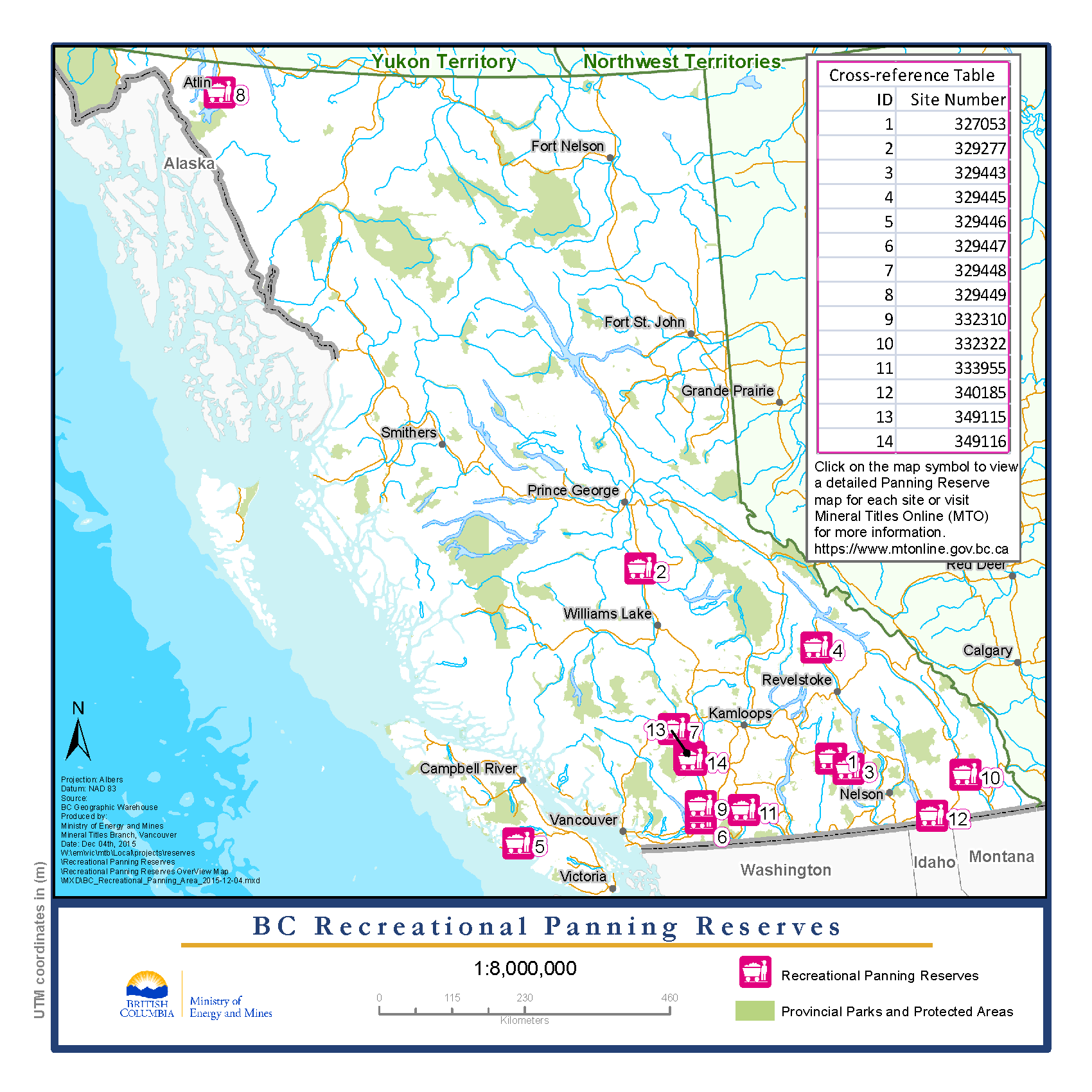
Open the overview map of BC (PDF, 574KB). Click on an icon at each reserve site to open up an individual location map (PDF) of a site.