Lesson 3 - RREE Assessment Overview
Objectives
This lesson will prepare participants by ensuring they understand the concepts, terms and process of the Routine Riparian Effectiveness Evaluation (RREE)
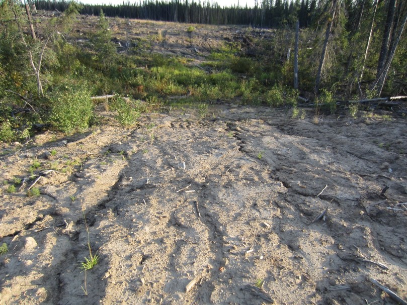
PHOTO: Example of a deactivated approach to a stream crossing. Erosion continues to deliver sediment to the riparian area.
What is Properly Functioning Condition?
Properly functioning condition is essentially a measure of the health of a stream and its associated riparian area. The RREE process seeks to determine if management treatments have impaired the health or function beyond the range of natural variability.
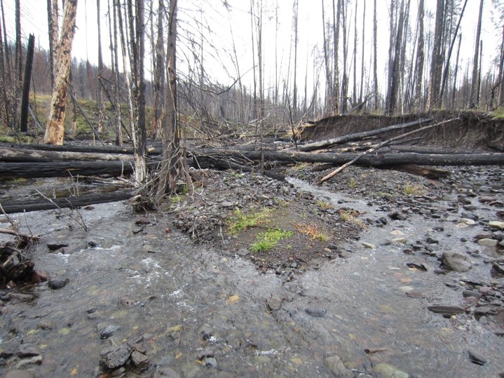
Left image: Wildfire impacted riparian area, with subsequent negative impacts now affecting the stream channel.
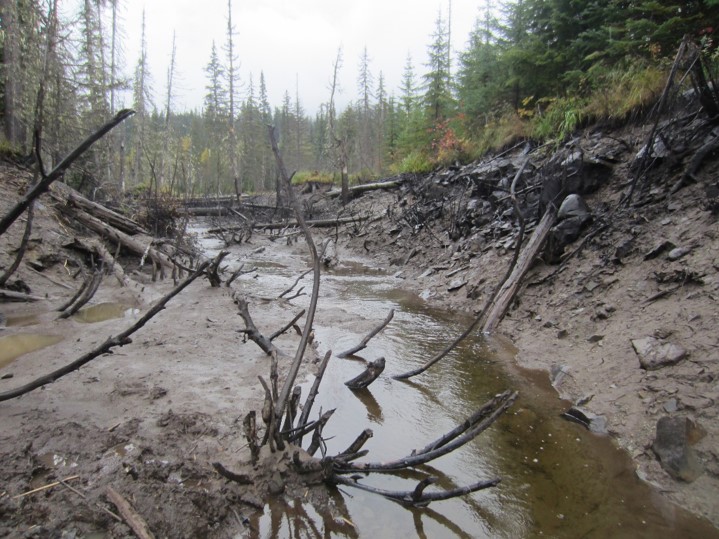
Right image: Beaver dammed stream that has just “blown out” but the impairment is still evident (although recovery is underway).
Properly functioning condition is the ability of a stream or river and its riparian area to:
- withstand normal peak flood events without experiencing accelerated soil loss, channel movement or bank movement;
- filter runoff;
- store and safely release water;
- maintain the connectivity of fish habitats in streams and riparian areas;
- maintain an adequate riparian root network or LWD supply; and
- provide shade and reduce bank microclimate change.
Principles of Site Selection
Statistical design principles are applied by FREP to ensure that the data collected and analyzed can be used at multiple scales (district, region, and province) with statistical validity and credibility.
To ensure the results are objective and defensible, all sites (i.e., cutblocks) sampled under FREP will be selected using random sampling. Each year, the random list of blocks is created by the Resource Branch and then Districts will review this list and commence with block selection, starting at the top of the list of blocks to determine if there are eligible streams to sample. Then the licensee is contacted to obtain a copy of the Site Plan and Operational Site Map (operator’s map).
We will sample individual stream reaches within or adjacent to a cutblocks that have had a minimum of one winter since the completion of logging. When deciding in the office if a stream is adjacent enough to be included as a potential sample reach, look at the length of the stream that lies within two riparian management area (RMA) widths of the “Opening ID’s” block boundary. Adjacent streams are defined as any stream reach that lies within two riparian management area (RMA) widths of the block boundary for a minimum stream length equal to 30 channel widths, or 100m whichever is greater.
If a cut block has more than one stream we will assess the stream with the “highest” riparian class (e.g., S2 before S3, or S5 before S6). If the stream being considered is a non-fish bearing stream (S5 or S6), try and do the reach closest to a fish stream. Where the streams all have equal value (all the same riparian class and drainage areas), randomly select a stream to sample. In addition, preference is to sample the stream below and downstream from road crossings.
Summary of Stream Eligibility
To qualify for annual FREP sampling, the stream must meet all of the following requirements:
- The stream must, by definition, be a stream and not merely a fisheries sensitive zone, wetland or non-classified drainage. (see table in the protocol page 15 for guidance)
- The stream classification must be consistent (i.e., the reach cannot be part S6 and S4 )
- The channel morphology should be mostly of one type (riffle/cascade pool, step pool or non-alluvial)
Can we drop a cut block?
If a person needs to ‘skip’ or drop a cut block in their list, there are allowances as long as the District documents their rationale. For example, cut blocks are commonly skipped if:
- There are no eligible streams within or adjacent to the block;
- If active harvesting or other activities in the cut block make it too dangerous to sample;
- If the cut block was subsequently burnt by wildfire after it was logged (but, if the cut block is a wildfire salvage block then it would be sampled if safe;
- Access is compromised and/or there are safety concerns.
How is Functioning Condition Assessed?
To assess the functioning condition of each reach, 15 questions (table 2) are asked about the characteristics of healthy streams and their riparian habitats. The relative health or “functioning condition” of the stream and its riparian area is based on the total number of No answers to the questions, as follows:
- 0–2 No answers = the stream is in properly functioning condition.
- 3–4 No answers = the stream is functioning but at risk.
- 5–6 No answers = the stream is functioning but at high risk.
- 7 or more No answers = the stream and riparian habitat is not properly functioning.
The first 9 questions relate to the conditions within the stream channel, and the final 6 questions (Q10-Q15) relate to the riparian area immediately beside the stream.
The ideal timing to conduct the assessments is during low flow periods (typically the summer season) and there should not be any snow on the ground. Assessors should avoid field work when the stream is swollen from heavy rains or snow meltwater runoff, both from a safety aspect and from needing to see into the stream to view the channel bed.
Checklist Design
Reading Assignment
Review the RREE Checklist (FS1248)
Checklist Design
The RREE checklist (FS1248) is designed to fit into a 6-ring field notebook. There are essentially 4 parts to the 18-page checklist: Baseline Observations, Field Data, 15 Functioning Condition Questions, and Conclusion.
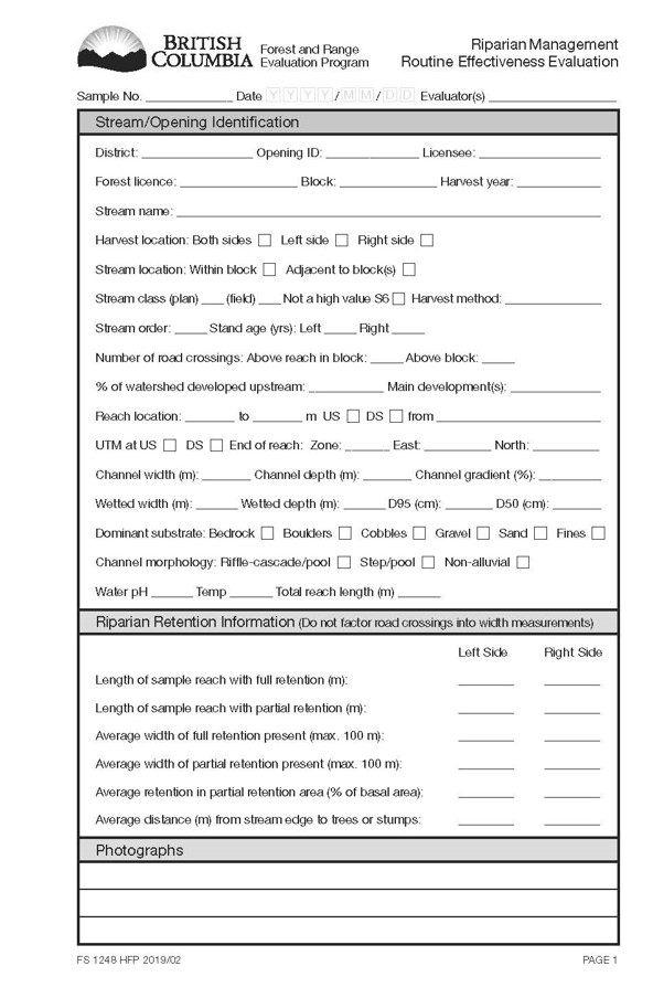
Baseline Observations (Checklist Page 1)
Characterise the stream and its riparian area retention.
Review the Licensee’s SP for most of the Opening ID information.
Collect this BASELINE information during your visit. Some information is mandatory BEFORE you start collecting data, such as:
- Stream Classification
- Channel Width and Depth
- Channel Morphology
Field Data (Checklist Pages 2-6)
Pages 2-6 of the checklist are for recording your field observations and measurements. Field data is divided into 3 types: point indicators, continuous indicators, and other indicators (observations). It is helpful to review these linkages as part of your pre-training preparations, so you begin to realize there is a lot of helpful guidance on these pages and to reduce the amount of memorization.
Three Types of Data/Observations:
- Point Indicators
- Continuous Indicators
- Other Indicators to Note
Properly Functioning Condition Questions (Checklist Pages 7 – 15)
There are 15 Questions to help decide on the health (functioning condition) of the stream.
The field data and observations are tallied and then used to answer the functioning condition questions. This step should be done in the field, at least with the stream in view and can take 15 minutes to complete.
Summary Conclusions (Checklist Pages 16-18)
The final step in the assessment is to capture the overall health of the stream, determine the causal factors for any impairment and isolate specific causes for the Questions answered as NO (aka, impaired).
The Number of “No” Answers to the 15 Questions Determines the Functioning Condition, or “Health” of the Stream/Riparian Area
- 0-2 “No” Answers = Properly Functioning Condition
- 3-4 “No” Answers = Functioning, but at Risk
- 5-6 “No” Answers = Functioning, but at High Risk
- >6 “No” Answers = Not Properly Functioning
Last (But Not Least) Determine the Cause of Each “No” Answer
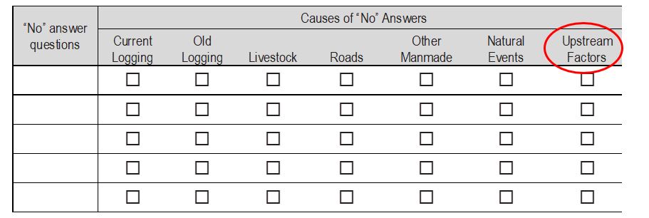
This is the last but crucial step in the FREP riparian assessments. We want to know what caused each no answer, so we ask the assessors to record the main causes of the problem to each MAIN question that was impaired. Sometimes this is obvious and other times if takes some exploration upstream.
Identifying the main cause of impairment is a very important part of the assessment. We want to know if natural events, upstream events and/or treatment events caused the NO answer(s). This helps us distinguish and separate background impacts from treatment impacts.
If you do not know what is causing a question’s impairment, and it is obvious the management practices are not affecting this question, then select “upstream factors”.
Record the SPECIFIC Causes for EACH “No”
The final step is the Summary Conclusion – the SPECIFIC CAUSES
You will need to take a step back from the data collection and ponder causal relationships between management treatments, natural processes and their role in impairments to the functioning condition of a stream.
Imagine a stream had 5 NO’s. 4 NO questions were attributed to “Current Logging” and 1 NO question attributed to “Animal Disturbance”, as summarized on page 16. On page 17, we ask the assessor(s) to take time to ascribe specifically the reason and extent. In this scenario, while current logging was the main cause, on its own, this does not help managers know what they could do to improve their practice. On page 17, we then state the specifics. For example, let’s say we observed LOW RETENTION both IN and ABOVE the reach as the cause for 2 NO’s (Q12 and Q15) and the FALLING & YARDING practices both IN and ABOVE the reach were the cause for 2more NO’s (Q2 and Q3); and BEAVER were the cause for the animal disturbance (Q5) but only IN the reach (we did not see signs of beaver upstream of our reach).
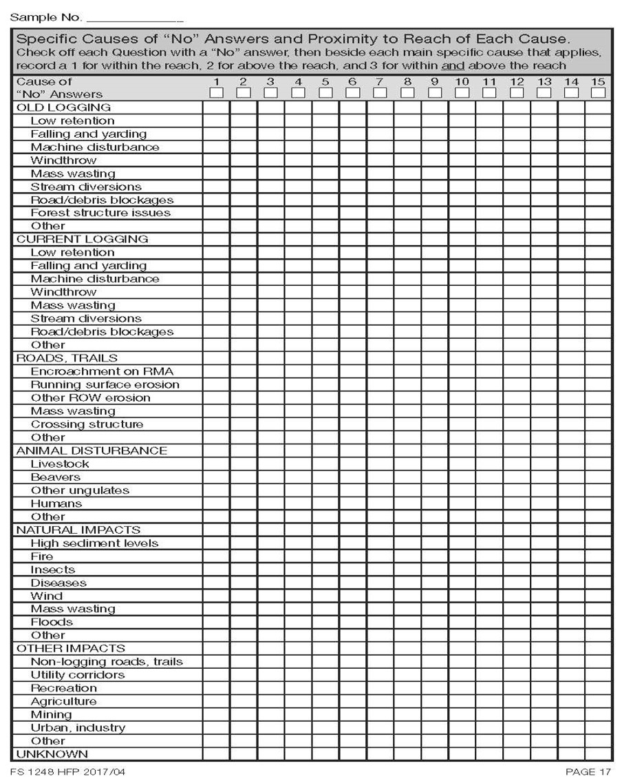
This table provides a clearer understanding of the Functioning Condition of the stream and can enable FREPers to better communicate to the stakeholder the level of impairment attributed to management practice, and whether the Source of the impairments are widespread or localized. This in turn guides stakeholders towards continuous improvement.
Reviewing Riparian Treatments
When we visit a stream, we want to review the Site Plan for prescribed treatments within the RMA, and then look to see if they were implemented and whether they are effective. This is not a C&E step but a chance to give recognition of practices that are effective or not.
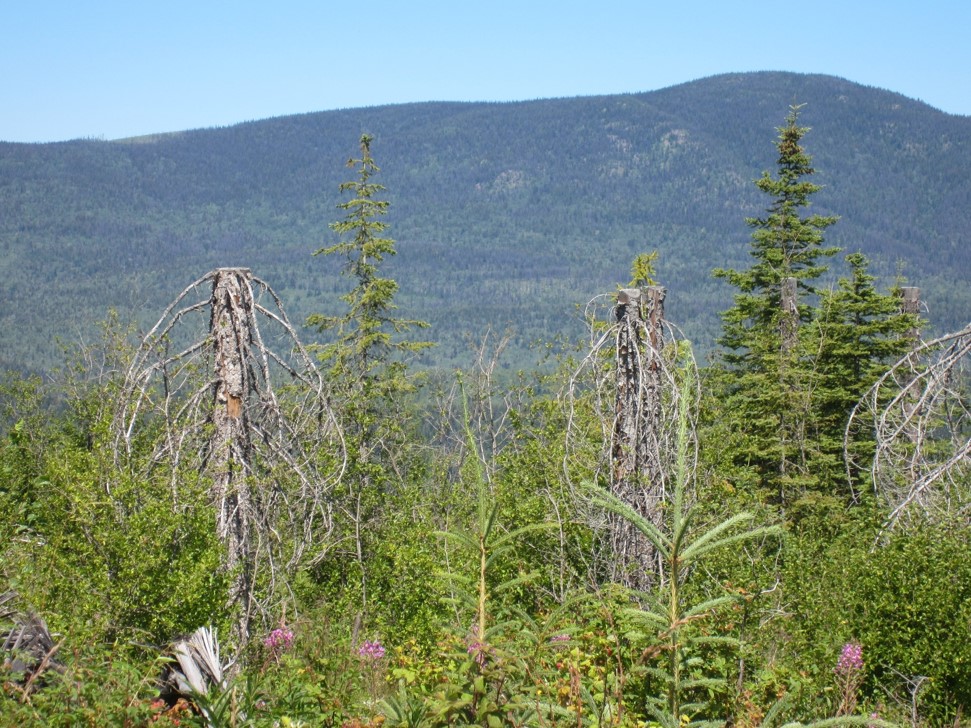
Photo: 5m MFZ with stubbed spruce & understory retained
Reviewing the treatments alongside the stream is an important part of the RREE assessment. It can be done as a focused review or concurrently while performing the RREE assessment. Record the retention characteristics for both sides of the stream in the Riparian Retention Information section of page 1 of the checklist. If you feel the information on riparian retention on page 1 does not adequately describe the condition of the riparian area, please provide a sketch of the riparian area on page 18 of the checklist. A photograph or two of the riparian area can also be invaluable in describing the riparian conditions.
As part of the RREE assessment we wish to review whether the prescribed treatments were undertaken and if they were effective. This observation is to be noted on page 18 of the checklist. Effective would mean that the impacts to the stream and riparian zone were not adverse. Determining if logging practices prescribed were fully implemented will take a bit of time and practice to observe. Here are a few examples of prescribed treatments:
Fall away: this is a practice where the hand fallers or mechanical feller buncher operator will ensure the trees are felled away from the stream. For hand falling, this will be easy to determine by looking at the residual stumps. If the undercut is positioned facing opposite to the stream’s position, then the tree was felled away. With bunchers, there is usually a “picket fence” of high cut stumps (or stubbs) 1-4m in height indicating the operator was working the wood away from the stream.
Fall to span: this is a practice where the hand fallers had a heavy leaner and the tree was felled directly across the stream. Subsequently the tree may have been removed, either by skidding or forwarding (lifting) the tree away from the stream. In this case, the stump will have an undercut positioned on the stream side of the stump.
Wind proofing: In some retention situations, the residual trees alongside the stream will be treated to reduce the risk of post-logging windthrow. Typically, this will be evident by topping treatments (cut tops) by climbers or by helicopter. In some situations, the upper crown will have been spiral pruned by climbers and you will notice missing limbs usually cut flush or stub cut 5-20cm long. Another treatment regime is to profile cut trees out of the buffer. This is done by removing dominant and/or windthrow-prone trees from alongside the harvesting edge. Consider also the width of RMZ retained, especially for streams with a RRZ – noting if the RMZ was effective in buffering the RRZ from windthrow.
Tree retention: In efforts to retain structural diversity and protect the stream banks, trees are sometimes left within the riparian zone. The selection criteria vary around the province. Look at the retention and is it still standing? To describe the level of retention, consider what tree layers were retained (vets, dominants, co-dominants, understory) or the types of trees (deciduous, conifers) or species, approximate basal area retained. This can be done using a quick prism sweep of trees retained and trees felled to get a proportion of retention).
Machine Free Zone: In this practice, merchantable trees are felled but the operator keeps the tracks of the machine a prescribed distance (commonly 5m) away from the stream banks. The feller buncher or forwarder is permitted to reach into the riparian area to fell and/or yard the trees. You will typically see a row of high stumps and/or residual flagging demarcating the machine exclusion zone. Additionally, most of the understory trees and shrubs will have been retained.
Designated stream crossings: In ground-based harvesting systems there is sometimes a need for the operator to cross the stream to access trees/areas without having a constructed road. Refer to the map for approximate locations and then in the field look for a skid trail that leads across the stream. You may see some evidence of rutting or decked cull logs that had been used to build a temporary crossing.
LESSON 3: Self-Check Questions
Answer either True or False to check your understanding:
1. It is OK to sample a water course that, after logging, has almost become a stream of 80m length.
2. After completing the field sampling one should always take a hike to review the timbered stream immediately upstream of a logged stream for context.
Answers
1. False – At the time of sampling, the water course MUST be a stream by definition, and it MUST be a minimum of 100m length to be considered as a reach.
2. True – Exploring the condition of the stream upstream is a great way to confirm the impairments that are natural from those reflecting management treatments.

