British Columbia Regional Streamflow Inventory Reports

The approach in the British Columbia Streamflow Inventory Reports can be used for estimating streamflow characteristics at ungauged sites employing a regional analysis procedure based on hydrologic zones.
What are hydrologic zones?
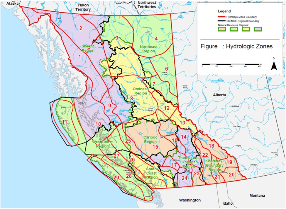
A hydrologic zone is an area with homogenous runoff characteristics where data can be reasonably extrapolated to estimate the characteristics at ungauged sites with an acceptable degree of accuracy. A hydrologic zone is typically identified based on physiographic features and/or a statistical study of hydrologic data. Due to the scarcity of hydrologic data in an extremely heterogeneous province such as British Columbia, this project used a physical mapping approach to delineate the hydrologic zones.
Map of Hydrologic Zones and Natural Resource Regions in B.C.
Other formats for this map can also be downloaded from: Hydrology: Hydrologic Zone Boundaries of British Columbia (DataBC)
Regional streamflow inventory reports
There are six revised and updated regional streamflow inventory reports covering the Ministry of Forests, Lands and Natural Resource Operations Natural Resource Regions. The reports can be used to estimate streamflow characteristics for ungauged sites using regionalization techniques.
The reports provide access to key streamflow statistics and basin parameters for each hydrometric station. Upstream watershed boundaries were delineated in-house to calculate the basin parameters and therefore vary from the values published by the Water Survey Canada.
This analysis only uses hydrometric stations with natural flow and a minimum 12 years of continuous data (with few exceptions). Both active and discontinued stations were used in the analysis. All detailed procedures are presented in the related Inventory of Streamflow reports below.
The standard discharge data used are published by the Water Survey of Canada (WSC) using data collected through the Canada-British Columbia Hydrometric Program (CBCHP). Most of the parameters presented in these reports are calculated based on data from the 1981 to 2010 Climate Normal period. Flow duration analyses and recurrence intervals of peak and low flows which are based on all available data.
The results of these analyses are compiled in datasheets, maps, tabular and graphical forms and grouped by hydrologic zones. This information enables hydrologists and engineers to make quicker and easier preliminary hydrologic estimates for water management purposes and the planning and preliminary design of water resource projects.
Inventory of Streamflow reports
Revised and updated reports are available from EcoCat, the Ecological Reports Catalogue below:
- Inventory of Streamflow in the Kootenay Region (June 2020)
- Inventory of Streamflow in the Thompson Okanagan Region (March 2020)
- Inventory of Streamflow in the South Coast and West Coast Regions (October 2017)
- Inventory of Streamflow in the Cariboo Region (September 2017)
- Inventory of Streamflow in the Omineca and Northeast Regions (February 2015)
- Inventory of Streamflow in the Skeena Region (October 2013)

