
R.W. Bruhn Bridge - Frequently Asked Questions (FAQ)
Find answers to some frequently asked questions about the RW Bruhn Bridge project.
Construction
- How can I apply to work on this project?
- Why are full closures needed?
- Will daytime full closures take place during the summer?
- When are full closures needed?
- What if I want to travel when there is a closure?
- What is considered local traffic?
- How do I get road closure updates?
- Will the construction of a new bridge have environmental impacts on the channel?
- When will rock blasting occur?
- Will the old bridge remain usable until the new bridge is open?
Traffic
- What is the alternate route between Sicamous and Salmon Arm during closures?
- Have speed limits on the alternate route been reduced?
- Why is the speed limit on RW Bruhn Bridge 50 km/hr?
Community and properties
- Are private properties that are in close proximity to blasting activities at risk of damage?
- What will the ministry do to minimize impacts to neighbouring properties?
- How will the Bruhn Bridge project impact noise levels in the District of Sicamous?
Project design and scope
- What options have been considered for the replacement of the RW Bruhn Bridge?
- Why is a new bridge needed? Can the existing bridge be repaired for ongoing use?
- Why was the two-bridge option not advanced?
- Why did the ministry select the one-bridge design in 2018 over the two-bridge option?
- Did the one-bridge 5-lane design that was presented to the public in 2018 include a highway overpass at the west end of the project?
- Why has the one-bridge design been reduced from 5-lanes to 4-lanes?
- The current one-bridge design identifies plans to close the existing Highway 1 access at Old Spallumcheen Road. Why is a second bridge not required to access Highway 1?
- Does the project include improvements on Highway 97A and 97B?
- Does the project include additional improvements east of Highway 97A?
- Will the project include artwork or other aesthetic considerations?
- What is the grade of the Old Sicamous Road/Old Spallumcheen Road connection?
- What will the new posted speed limits be after complete of the project?
Maintenance
- Will the District of Sicamous be responsible for the cost of maintaining the new roadways, retaining walls, and structures resulting from the project?
- How will snow removal be managed to avoid dumping snow off the Bruhn Bridge onto the Old Sicamous Road/Old Spallumcheen Road connection?
Boat launch and houseboats
- Will the project impact vehicle and boat trailer parking at the Finlayson Boat Launch?
- How will the project impact the existing boat launch under Highway 1?
- Will the new highway bridge be able to accommodate houseboats? Are there any other navigational concerns for houseboats and other vessels?
Active transportation and multi-use path
- How is accommodation being made for cyclists on Highway 1?
- How will the project accommodate pedestrians and cyclists?
- Will the project integrate with the planned Rail Trail project?
- Is the new multi-use path proposed on the south side of new highway bridge safe?
- Can the height of the barrier separating the multi-use path from highway traffic be increased?
Engagement
- What opportunities are there for the public to provide feedback on the project?
- How has the ministry engaged on the project since funding was approved in late 2018?
- Have you notified first responders?
Construction
How can I apply to work on this project?
The contractor is responsible for all aspects of construction, in accordance with BC Infrastructure Benefits (BCIB) requirements that ensure British Columbians get access to good-paying, career-building jobs, skills development and apprenticeships. BCIB offers information for both contractors seeking information about working on projects with Community Benefits Agreements, and employees seeking career opportunities.
Why are full closures needed?
Intermittent road closures on Highway 1 will be required to facilitate some activities associated with new bridge construction, such as rock blasting. These closures keep crews and the travelling public safe while work is underway.
Will daytime full closures take place during the summer?
Effective June 15, 2025, no daytime full bridge closures are permitted.
When are full closures needed?
A rolling three-week schedule of planned closures is available on the main project page. The ministry has provided the following times within which the contractor may be permitted to implement Highway 1 closures for construction throughout construction:
Summer (June 15 to September 15)
- 7:30 p.m. to 9 p.m.
- 12 a.m. to 4 a.m.
Winter (September 16 to June 14)
- 9 a.m. to 3 p.m.
- 12 a.m. to 4 a.m.
What if I want to travel when there is a closure?
When a full closure is in place, all travel between Sicamous and Salmon Arm will use Highway 97A and Highway 97B as an alternate route. Local traffic will have limited access to travel within Sicamous at the top of each hour. The contractor is required to let local traffic across the existing bridge at the top of each hour. The only exception is during the summer between 7:30 p.m. and 9 p.m., during which no local traffic access across the bridge will be permitted.
When the highway is open for traffic, generally, there may be times when single-lane-alternating traffic will be in place, and we encourage everyone to plan ahead and allow for extra time if you want to ensure you arrive at your destination on schedule.
NOTE TO TRAVELLERS: please follow posted Alternate Route signs when a full closure is in place, since GPS and other online wayfinding apps may not have the most current information. More information is available on the Alternate Route page.
What is considered local traffic?
For the R.W. Bruhn Bridge Project, local traffic refers to traffic that needs to travel within Sicamous, such as to travel between Old Sicamous Road, Old Spallumcheen Road, Silver Sands Road and downtown Sicamous. It does not include traffic travelling between Sicamous and Salmon Arm. When a full closure is in effect, all traffic will use Highway 97A/Highway 97B to travel between Sicamous and Salmon Arm. Note that special provisions are in place for responders attending to an emergency.
How do I get road closure updates?
The main project page provides a three-week planned closure schedule so that people can plan ahead www.drivebc.ca and on-road signs will always be the source of truth, in real-time, as to whether a closure is in place. At the bottom of our main project page, you can also sign up to receive schedule updates by email.
Will the construction of a new bridge have environmental impacts on the channel?
Wildlife and spawning surveys have been undertaken and required mitigation measures have been developed to ensure that construction does not impact sensitive vegetation, wildlife or habitat features.
Underwater archaeological investigations have been completed and information from these investigations have guided pier placement as part of the bridge design.
The project construction will include environmental enhancement activities to further offset project impacts through improvements which will enhance vegetation and biological productivity within the project area.
When will rock blasting occur?
Blasting will only be permitted during the approved daytime full closure windows and the contractor will be required to provide advance notice. On-road signs, the website and other public notices will also be used to alert the general public.
Will the old bridge remain usable until the new bridge is open?
The old bridge will remain open until the new bridge can be used for travel. There may be a period of time where both bridges are used to facilitate certain tie-ins to the road network, but there will be no time where neither bridge is available for use other than during the approved closure windows noted on our website.
Traffic
What is the alternate route between Sicamous and Salmon Arm during closures?
Highway 97A and Highway 97B are regularly used as an alternate route during temporary Highway 1 closures. These situations have shown the corridor to adequately handle the additional traffic.
Additional traffic modelling has been completed, and it is expected that the alternate route will operate at an acceptable level. Area residents may notice some additional delays compared to existing conditions.
Have speed limits on the alternate route been reduced?
The ministry does not plan to reduce the speed limit on the detour route, since unnecessarily lowering the speed limit can lead to driver frustration, negatively impacting safety. However, we will monitor traffic behaviour and adjust if necessary. We’ve had good success without the need for speed limit changes along alternate routes for similar projects works and are using it as a model for our traffic management and monitoring for this project.
Why is the speed limit on RW Bruhn Bridge 50 km/hr?
Highway 1 near the R.W. Bruhn Bridge has a reduced speed limit of 50 km/hr as a safety precaution due to the temporary railing installed following a single-vehicle incident in August 2024. Speed reductions are in effect 24/7, even when bridge construction crews are not working.
Community and properties
Are private properties that are in close proximity to blasting activities at risk of damage?
The contractor will be required to conduct a pre-construction survey of houses and structures that are in close proximity to blasting works and will complete a post-construction survey to ensure there was no damage to any structures. All blasting shall follow the Best Practices Guide for Urban Blasting Operations, and the contractor will be required to take blasting control measures to minimize risk to property and public safety. If any damage is deemed to be caused by the contractor, all repairs would be covered under their insurance.
What will the ministry do to minimize impacts to neighbouring properties?
The ministry is actively consulting with affected property owners to provide information about the project and its potential effects on private properties, including plans to help mitigate effects.
How will the Bruhn Bridge project impact noise levels in the District of Sicamous?
- Noise impacts associated with the project are being assessed and mitigated in compliance with the Ministry’s Noise Policy
- Baseline noise levels have been collected through field work conducted in 2019 and 2020
- Predictive modelling has been used to estimate future traffic volumes and associated noise levels following the Project completion
- The Ministry will conduct a post-construction noise assessment to understand whether mitigation should be considered under the Ministry’s Noise Policy
Project design and scope
What options have been considered for the replacement of the RW Bruhn Bridge?
In February 2018, the ministry held an open house to gather input from the community on replacement options for the RW Bruhn Bridge. For background, view the 2018 open house material.
In December 2018, after extensive consultation, analysis and field work, the ministry identified a one-bridge design for replacement of the RW Bruhn Bridge. The information bulletin can be viewed here.
Why is a new bridge needed? Can the existing bridge be repaired for ongoing use?
The existing bridge is over 50 years old and while it is safe for users, the aging infrastructure is nearing the end of its service life and needs replacement.
Major bridge rehabilitation has been considered, but it has been determined that bridge replacement is necessary given the condition and constraints of the aging structure and the significant risk associated with its rehabilitation.
Why was the two-bridge option not advanced?
The results of archaeological field work and the cultural significance of the project area has guided the ministry’s decision to advance the one-bridge design over the two-bridge option, given the need to minimize impacts.
Other important considerations included technical, financial, and environmental information, along with feedback from local government, Indigenous communities, the public and the Project Liaison Committee comprised of technical, community and business group representatives.
Why did the ministry select the one-bridge design in 2018 over the two-bridge option?
The results of archaeological field work and the cultural significance of the project area has guided the ministry’s decision to advance the one-bridge design over the two-bridge option, given the need to minimize impacts.
Other considerations in the decision included technical, financial and environmental information, along with feedback from local government, First Nations, the public and the project liaison committee.
Did the one-bridge 5-lane design that was presented to the public in 2018 include a highway overpass at the west end of the project?
The one-bridge design that was presented to the public in 2018 did not include a highway overpass at the west end of the project. Instead, a fifth lane was proposed on the bridge to accommodate eastbound highway access from Old Spallumcheen Road by way of a dedicated right-hand turning lane extending from Old Spallumcheen Road to Gill Avenue.
During design, the design engineers identified safety issues including weaving and conflicts between eastbound highway traffic on the fifth lane of the bridge and traffic entering the highway from Old Spallumcheen Road. Safety is improved by closing the accident-prone Old Spallumcheen intersection and relocating this access point further west, thus eliminating traffic weaving issues on the bridge and reducing conflicting movements on connecting roads which were identified as risks with the 5-lane design.
This design significantly reduces project impacts in areas of extreme cultural and archaeological sensitivity, makes the highway safer for users, and allows the existing R.W. Bruhn Bridge to remain in service during construction of the new bridge.
Why has the one-bridge design been reduced from 5-lanes to 4-lanes?
The ministry has not changed the scope of the Project. The connection of Old Spallumcheen Road and Old Sicamous Road to Highway 1 remains in the scope of the project. The four-lane design maintains the same functionality of the 5-lane design by eliminating the fifth lane on the bridge that was designed for Old Spall Rd traffic and accommodating highway access via a highway overpass at the west end of the project.
During design, the design engineers identified safety issues including weaving and conflicts between eastbound highway traffic on the fifth lane of the bridge and traffic entering the highway from Old Spallumcheen Road. Safety is improved by closing the accident-prone Old Spallumcheen intersection and relocating this access point further west, thus eliminating traffic weaving issues on the bridge and reducing conflicting movements on connecting roads which were identified as risks with the 5-lane design.
This design optimization significantly reduces project impacts in areas of extreme cultural and archaeological sensitivity and allows the existing R.W. Bruhn Bridge to remain in service during construction of the new bridge.
The current one-bridge design identifies plans to close the existing Highway 1 access at Old Spallumcheen Road. Why is a second bridge not required to access Highway 1?
The connection of Old Spallumcheen Road and Old Sicamous Road to Highway 1 remains in the scope of the project. The current design includes a new underpass connection under the highway at the west end of the project so that both eastbound and westbound Highway 1 access is accommodated at the west end of the project for local residents of Old Spallumcheen Road and Old Sicamous Road.
Does the project include improvements on Highway 97A and 97B?
The ministry will improve Highway 97A/B in advance of project construction. Key improvements are:
- Implement signal timing changes at Highway 1/97A and Highway 1/97B
- Extend the eastbound left turn lane at the Highway 97A/B junction for additional storage
- Resurface key sections the alternate route between Grindrod and Sicamous (Parksville St)
- Install a temporary signal at the Highway 97A/B junction
We’re also installing additional signs along the route, including:
- Advanced direct messaging signs advising of closures and the route diversion
- Static signs identifying the alternate route, to detour inappropriate short-cutting
- Static signs identifying the final turn-around opportunity 3.5 km west of the project site
- Speed reader boards at key locations to promote increased awareness
Does the project include additional improvements east of Highway 97A?
The Bruhn Bridge project includes approximately 1.9 km of highway four-laning between the existing Old Sicamous Road intersection and Silver Sands Road. The total project length is approximately 2.45km from limit to limit, including tapers. At the eastern project limit, the second eastbound travel lane extends beyond Silver Sands and terminates as a right-turn lane at the Highway 97A intersection to ensure driver safety. The ministry has been working on a separate study in partnership with the District of Sicamous to develop a local transportation strategy to accommodate the future needs of the highways and local road network, beyond the boundaries of the Bruhn Bridge project.
Will the project include artwork or other aesthetic considerations?
The ministry is currently engaging with Splatsin to identify opportunities for the inclusion of Indigenous artwork as part of the project to highlight the cultural significance of the area.
What is the grade of the Old Sicamous Road/Old Spallumcheen Road connection?
The Old Sicamous Road/Old Spallumcheen Road connection has a maximum grade of 10.2%, which is within the standards set by the Transportation Association of Canada of 11%.
What will the new posted speed limits be after complete of the project?
The highway design speed transitions from 100km/h to 80km/h at the west end of the project, approximately 120m west of Bruhn Bridge. The 80km/h design speed is retained for the remainder of the project to the eastern limits at Highway 97A. The transition to the 60km/h posted speed limit will remain approximately 250m east of Silver Sands Road, prior to the signalized 97A intersection.
Maintenance
Will the District of Sicamous be responsible for the cost of maintaining the new roadways, retaining walls, and structures resulting from the project?
The ministry intends to maintain provincial ownership of all new infrastructure resulting from the project. Accordingly, the ministry will be responsible for the rehabilitation and maintenance costs associated with the new roadways, retaining walls, and structures.
How will snow removal be managed to avoid dumping snow off the Bruhn Bridge onto the Old Sicamous Road/Old Spallumcheen Road connection?
Snow removal and storage strategies are actively being developed by the ministry’s District Operations team in conjunction with the road area maintenance contractor for the project. Safety is the ministry’s top priority and safe methods for snow removal will be developed.
Boat launch and houseboats
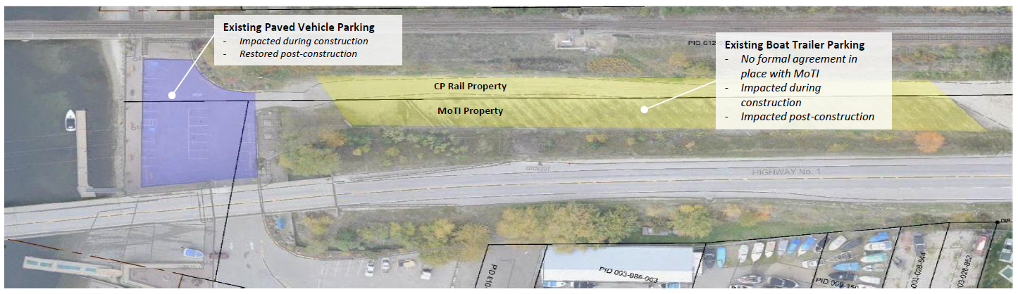
Will the project impact vehicle and boat trailer parking at the Finlayson Boat Launch?
Construction of the Bruhn Bridge project will impact the nineteen (19) existing paved vehicle parking stalls located under the Bruhn Bridge, as shown in purple on the figure that follows. To mitigate these impacts, the ministry will provide funding to the District of Sicamous to lease nearby land for the provision of replacement parking over a 5-year term. Following construction, these 19 vehicle parking stalls will be reinstated in their original location.
Construction will also impact the existing thirty-size (36) boat trailer parking stalls that are located north of Highway 1, as show in yellow on the figure that follows. To mitigate these impacts, the ministry will provide funding to the District of Sicamous to lease nearby land for the provision of replacement parking over a 5-year term. Following construction, these 36 boat trailer parking stalls will not be reinstated in their original location, as this existing MoTI property will be used for the new highway four-laning.
A 3-year construction period is anticipated for the Bruhn Bridge project and accordingly, a 5-year term has been established for provision of temporary replacement parking. This will allow for additional mitigation of parking in the case of any delay to the construction completion date. This will also allow additional time beyond the completion of construction for the District of Sicamous to determine a new long-term solution for provision of boat launch parking in the area.
How will the project impact the existing boat launch under Highway 1?
Efforts will be made to reduce impacts to the Finlayson boat launch during construction to the greatest extent possible, particularly during peak summer months. Removal of the existing bridge is anticipated during the third season of construction, with temporary closures to the boat launch expected to ensure the safety of the public.
A detailed construction management and communication plan will be developed by the construction contractor to minimize construction impacts and ensure advanced communication of planned temporary and intermittent closures to the marine community.
Will the new highway bridge be able to accommodate houseboats? Are there any other navigational concerns for houseboats and other vessels?
A Marine Liaison Committee was established in 2018 to gather feedback from commercial and recreational water users and from Transport Canada on the new bridge design. The new bridge will maintain the same vertical clearance and will exceed the horizontal clearance of the existing R.W. Bruhn Bridge structure. The new bridge will require only one in-water pier as compared to the existing bridge which has two in- water piers.
Additional consultation with Transport Canada and the marine community took place in 2021 to review the detailed design and to develop construction communication protocols and mitigation strategies to minimize impacts to marine users during construction. Further engagement with Transport Canada and the marine community is planned to take place in 2023 prior to commencement of construction to provide additional information on planned mitigation strategies and construction phase communication protocols.
Active transportation and multi-use path
How is accommodation being made for cyclists on Highway 1?
Cyclists travelling along the Trans-Canada Highway from Salmon Arm to Sicamous will use the current highway shoulder which has a width that varies between 1.0m to 2.5m. The Bruhn Bridge project will include a paved 2.5m shoulder along both sides of Highway 1 within the Project limits to promote safe passage for cyclists traveling along the highway corridor in accordance with the BC Active Transportation Design Guide. In addition to the 2.5m wide highway shoulder, cyclists will also have the option to cross the Sicamous Narrows by way of the new 3m wide multi-use path between Old Spallumcheen Road and Gill Avenue. The new multi-use path has been designed so that local pedestrians and cyclists can cross the Sicamous Narrows without any interaction with Highway 1.
How will the project accommodate pedestrians and cyclists? Will the project integrate with the planned Rail Trail project?
A three-metre-wide multi-use path will provide a safe connection for pedestrians and cyclists from Gill Avenue to Old Spallumcheen Road across the Sicamous Narrows. The new path will be located on the south side of the bridge and will interconnect with the future Rail Trail project.
The project is engaging with Splatsin on the design of the multi-use path connection to the future Rail Trail, given the cultural and archaeological sensitivity of the area and the need to minimize impacts. Engagement is also ongoing with technical representatives from the Rail Trail project to inform the final design
Is the new multi-use path proposed on the south side of new highway bridge safe?
Currently, pedestrians and cyclists accessing Sicamous from the east side of the narrows use the existing highway shoulder, which is as narrow as 1m, and a raised 1.7 m wide sidewalk on the bridge. Both the existing shoulder and sidewalk are directly adjacent to highway traffic.
The project includes a new 3m wide multi-use path along the south side of Highway 1 between Old Spallumcheen Road and Gill Avenue. Pedestrian and cyclist safety in ensured by separating the multi-use path from vehicle traffic by a concrete barrier in accordance with ministry standards. The travel lanes are further separated from the multi-use path by a 2.5 m wide shoulder adjacent to the barrier.
Pedestrians and cyclists from Old Sicamous Road residences will access the multi-use path on the new bridge along the shoulder of the new road under the bridge that connects Old Sicamous road to Old Spallumcheen Road. This connecting road includes a paved 1.5 m wide shoulders on either side to accommodate pedestrians and cyclists in accordance with ministry design standards for a local, low speed road (40km/h). The multi-use path, and its connection with Old Spallumcheen road and Old Sicamous Road, are designed so that local pedestrians and cyclists can cross the Sicamous Narrows without any interaction with Highway 1.
Refer to the following plan showing pedestrian and cyclist journeys following completion of the Project.

The multi-use path proposed for the Project is consistent with what has been included on other ministry bridge projects, such as the recently completed Lizard Creek bridge that forms part of the overall multi-use path trail network connecting Fernie Alpine Resort to the town of Fernie. This bridge also includes a 3.0m multi-use path and is separated from traffic by the same 810mm high concrete barrier that is proposed on the Bruhn Bridge multi-use path. However, the Lizard Creek bridge has a slightly narrower 2.0m paved shoulder separating the multi-use path from traffic than the proposed 2.5m shoulder for the Bruhn Bridge. The posted speed limit on the Lizard Creek bridge is 80km/h, consistent with the proposed speed limit for the Bruhn Bridge.
Can the height of the barrier separating the multi-use path from highway traffic be increased?
Raising the height of the barrier that separates the multi-use path from vehicles between Old Spallumcheen Road and Gill Avenue is not recommended, as the proposed concrete barrier on the bridge (810 mm high) and approaches (690 mm high) considers the safety of all highway users, including vehicles, cyclists traveling along the highway shoulder, and cyclists and pedestrians traveling along the multi-use pathway.
Additional protection height (barrier railing) is recommended only by the BC Active Transportation Design Guide in circumstances where the traffic shoulder is narrow, which is not the case here, as a 2.5m wide shoulder is provided to accommodate cyclists passing by Sicamous traveling along the Trans-Canada Highway. For cyclists on the highway shoulder, it is safer not to include additional barrier protection height, such as barrier railing, as the current 810mm height ensures free movement of cyclists over the barrier in case of a collision.
Engagement
What opportunities are there for the public to provide feedback on the project?
Since fall 2014, meetings have been held with local government, Indigenous communities, impacted property owners, and liaison committees to gather input on the project.
In 2018, the ministry held a public open house in Sicamous. Information previously completed public engagements, including the results, are available online at: www.gov.bc.ca/bchwy1-bruhn
Please visit the website to keep updated on the project. For more information or to provide feedback on the project, contact rwbruhnbridge@gov.bc.ca.
How has the ministry engaged on the project since funding was approved in late 2018?
The ministry has made efforts to engage with a diverse group of interested parties throughout all phases of design. The 2020 year presented some unexpected circumstances, including the onset of the COVID-19 pandemic and an early provincial election, which made engagement particularly difficult during this time. Key engagement activities undertaken on the project since 2018 have included engagement with local government staff on impacts to municipal infrastructure, engagement with District of Sicamous Council, engagement with Splatsin leadership and staff and other Secwepemc communities, engagement with impacted private landowners, engagement with technical representatives from Transport Canada, BC Hydro, Columbia Shuswap Regional District, Regional District of North Okanagan, and the Rail Trail.
Have you notified first responders?
The ministry has engaged with first responders throughout the project design phase to inform contract language so that the contractor understands all requirements when preparing the Traffic Management Plan and provides access to first responders if/when required. Once the ministry accepts the contractor’s plan, our role will be to monitor performance during construction. This will include ongoing engagement with emergency services personnel.
Subscribe
Enter your email address to subscribe to updates of this page.