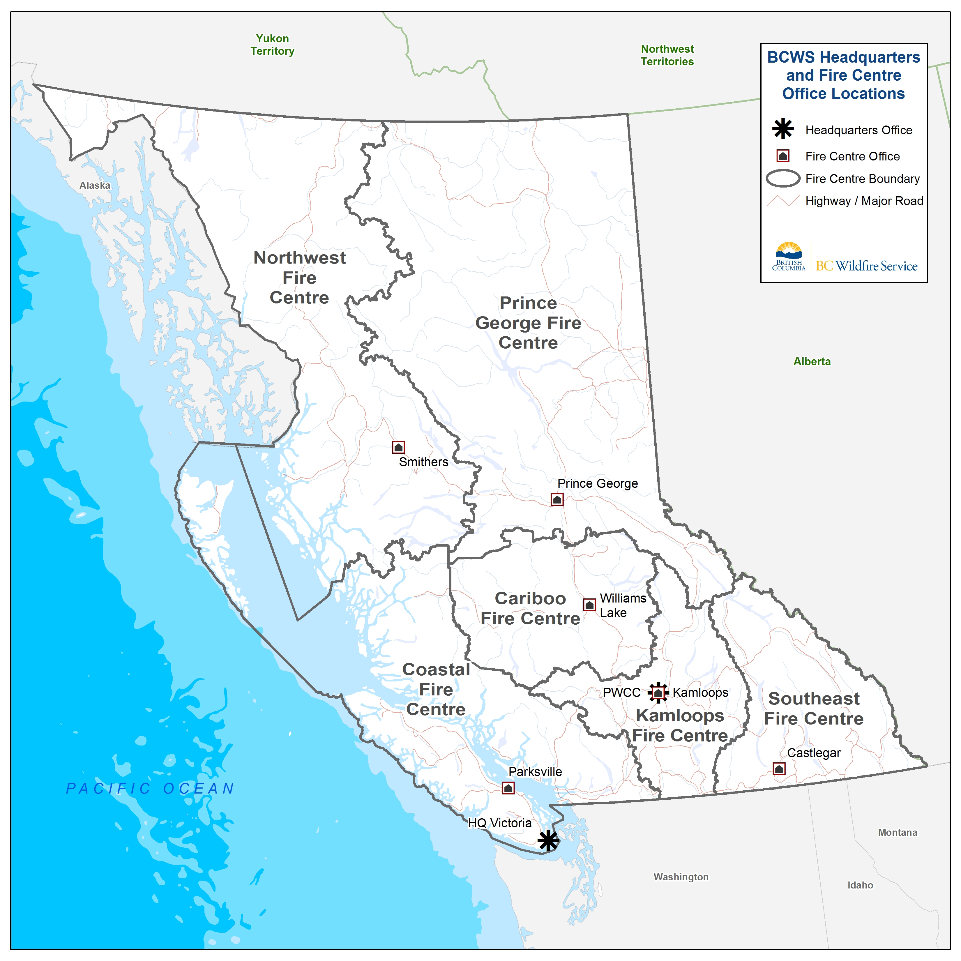
Fire Centres
The province is divided into six regional fire centres:
These are further divided into local fire zones (PDF, 676KB). Each fire centre is responsible for wildfire management within its boundaries. The Provincial Wildfire Coordination Centre and Headquarters oversee and coordinate all province-wide functions of the BC Wildfire Service (BCWS).
For media or public inquiries, contact a regional or provincial fire information officer.

Cariboo
The Cariboo Fire Centre in Williams Lake is responsible for coordinating wildfire response in the central interior of B.C.
This area encompasses approximately 8.2 million hectares, stretching from Clinton, north to the Cottonwood River, east to Wells Gray Provincial Park and west to Tweedsmuir Provincial Park, divided into two main climatic belts: the western dry belt and the eastern wet belt.
As a result, a mixture of thinly grassed meadows, sagebrush and lone coniferous trees and well-spaced forests are found in the west of the region. In the east, there are extensive forests of cedar, hemlock, spruce and balsam trees, with a milder climate lying between the two belts.
Contact an Information Officer
Cariboo Fire Centre
778-799-2100
BCWS.CAFCInformationOfficer@gov.bc.ca
Coastal
The Coastal Fire Centre, located in Parksville on Vancouver Island, coordinates wildfire suppression and prevention across south coastal B.C., the most heavily populated area in the province.
This area encompasses approximately 13 million hectares of land, extending west of the highest point on the Coast Mountain range from the U.S./Canada border at Manning Park to the northern border of South Tweedsmuir Provincial Park, the Lower Mainland, Sunshine Coast, Vancouver Island, the Gulf Islands and Haida Gwaii.
The presence of six distinctly different microclimates in the area gives rise to vastly different fuel types and fire danger ratings. Much of the terrain in the Coastal Fire Centre is steep and rugged with thick brush, large timber and large bodies of water. With over 75% of the population of B.C. living in this area, there is a high potential for interface fires that affect homes, cabins, watersheds, communication towers, transmission lines, roads and other infrastructure.
Contact an Information Officer
Coastal Fire Centre
250-951-4209
BCWS.COFCInformationOfficer@gov.bc.ca
Kamloops
Located close to Kamloops airport, the Kamloops Fire Centre coordinates the wildfire response across south central B.C.; from Blue River in the north to the U.S. border in the south and from Bridge River in the west to Monashee Mountains in the east. The fire Centre covers approximately seven million hectares of land.
The terrain within this area is extremely diverse, ranging from glaciers in the north to open range and semi-arid desert in the Southern Okanagan; from steep dry canyons in the Lytton and Lillooet area to the interior rainforest of Salmon Arm. The area supports a variety of vegetation including ponderosa pine, Douglas-fir, jack or lodgepole pine, spruce, balsam and sagebrush.
Contact an Information Officer
Kamloops Fire Centre
250-554-5965
KFCINFO@gov.bc.ca
Northwest
The Northwest Fire Centre located in Smithers coordinates the wildfire response for an area which covers over 24 million hectares, a quarter of the province. Stretching from the west coast to just west of Endako and from the Yukon border to Tweedsmuir Provincial Park.
The Northwest Fire Centre encompasses part of the undulating interior plateau as well as the rugged Coastal mountain range. The forests in this area consist primarily of pine and spruce trees. Balsam can also be found in higher elevations with hemlock and red cedar becoming more prevalent along the coast.
Contact an Information Officer
Northwest Fire Centre
250-876-6844
BCWS.NWFCInformationOfficer@gov.bc.ca
Prince George
The Prince George Fire Centre is located within the largest forest region in the province; an area ten times the size of Vancouver Island, which encompasses 33.6 million hectares.
Covering the central and northeast portion of the province, the boundaries of the Prince George Fire Centre include the north of the Interior Plateau and the Omenica Mountains to the north, sections of the Rocky Mountain Trench and Peace Liard country to the east and part of the Cariboo range to the south.
Largely rugged and remote, the region is home to sub-alpine fir, interior cedar-hemlock, boreal and sub-boreal spruce forest ecosystems.
Contact an Information Office
Prince George Fire Centre
250-561-4629
INFOPG@gov.bc.ca
Southeast
Based at the Castlegar municipal airport, the Southeast Fire Centre, extends from the U.S. border to Mica Dam and from the Okanagan Highlands/west side of the Monashee Mountains to the B.C./Alberta border. Several provincial parks including Valhalla, Kokanee Glacier, Top of the World and Elk Lakes, are also located in this area. The fire centre covers over eight million hectares of land.
The Southeast Fire Centre varies from a wet climate in the north to a dry Okanagan climate in the southwest, the mountainous terrain can experience high temperatures in summer and very low temperatures in winter. Vegetation is very diverse across the region and includes many commercial hardwood and softwood species such as larch, pine, spruce, fir, Douglas-fir, cottonwood, aspen, red cedar and birch.
Contact an Information Officer
Southeast Fire Centre
250-318-7715
BCWS.SEFCInfo@gov.bc.ca
Provincial Wildfire Coordination Centre (PWCC) and Headquarters
The PWCC and BCWS Headquarters (located in Kamloops and Victoria, respectively) oversee and coordinate all province wide functions of the BCWS, including:
-
Aviation Management
-
Provincial Airtanker Centre
-
Interagency agreements and assistance
-
Safety and training
-
Resource management
-
Public communications
-
Geographical Information System (GIS) Services
-
Strategic direction
-
Contract management
-
Finance
-
Administration
-
Provincial Wildfire Reporting Centre
