
Visual Landscape Inventory
The first step in managing B.C.’s scenery is to identify the most visible and sensitive landscapes. A visual landscape inventory (VLI) maps the visible topography from public-use areas such as communities, recreational areas, highways and waterways. B.C.’s most sensitive landscapes are usually steep, forested slopes exposed to many viewers; the least sensitive landscape are usually low in relief, more remote, and with few viewers or viewing opportunities.
Procedures & Standards for VLI & Digital Update/Mapping
The VLI identifies, classifies and records visual values on maps made from specific view locations and by travelling waterways and highway corridors. Views are:
- assessed against specific criteria;
- rated for their sensitivity to forest alterations; and
- assigned a visual sensitivity class (VSC) on a scale of 1 (very high sensitivity) to 5 (very low sensitivity).
This manual outlines the B.C. Government's VLI procedures and standards:
- VLI Procedures & Standards Manual (PDF, 1997)
The VSC mapping and associated visual quality objectives (VQOs) recommend which visual alterations could be applied to the landscape, based on the following government document. These recommendations may be used in making decisions for establishing VQOs on the land base.
A VLI brochure provides technical definitions and further descriptions of the VLI purpose and process.
Digital Update & Mapping
Once a VLI’s field component is completed, data are entered into a geographic information system dataset. The following manual provides district managers and resource professionals with the procedures and standards for capturing, downloading, updating and uploading VLI spatial and attribute data files to the B.C. Geographic Data Warehouse (BCGW) for storage, distribution and display.
Uploading & Downloading District Tiles
When the VLI is an update to older mapping, the current VLI needs to be downloaded, updated and re-submitted for review by the VLI specialist and approval by the regional visual specialist.
Contact the visual resource management program for permission to download a tile for editing. Then visit the following website and click "Extract Recreation Data". Choose the district tile desired and then the layer desired for edits (e.g., VLI layer, Viewpoints layer). Or, any layer can be downloaded for viewing (no permission required – click "Download Recreation Data").
Once edits are done, resubmit the tile for review (to the district VLI specialist) and for approval (to the regional visual resource management specialist).
Metadata for the fields used in the VLI layer can be found either in the Data Catalogue or field name variations document:
Viewing Visual Landscape Inventory Data
The visual information management system (VIMS) stores VLI mapping, scenic area designations, established VQOs, viewpoints, view arrows and screening. VLI data can be viewed using the Visual Landscape Inventory Viewer.
Alternatively, VLI data is can be viewed using iMap. VLI spatial layers are provided in the Parks, Recreation, and Tourism theme.
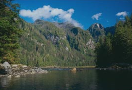
B.C.'s most sensitive landscapes are usually steep forested slopes exposed to many viewers.
Contact information
For enquiries about visual resource management in British Columbia, please contact us at: