
Managing the Forest Landscape
Establishing Scenic Areas & Visual Quality Objectives
Once a landscape’s sensitivity has been assessed, a visual quality objective (VQO) is established to guide forest management activities. VQOs describe levels of visual alteration appropriate for landscapes based on their visual sensitivity. VQOs are established at the local level by the resource district manager in consultation with First Nations, the public and other stakeholders. The Forest Planning and Practices Regulation defines five classes of VQO: Preservation, Retention, Partial Retention, Modification and Maximum Modification.
Government Actions Regulation, Scenic Area & VQO Orders
Under the Forest and Range Practices Act (FRPA), the Government Action Regulation (GAR) provides the authority, criteria and process for establishing scenic areas and VQOs. Many of B.C.’s scenic areas and VQOs were carried forward in the transition from the Forest Practices Code to FRPA. In cases where scenic areas lacked VQOs or the VQOs were flexible, VQOs have been established through GAR orders. GAR orders must be posted.
Visual Impact Assessment
A visual impact assessment (VIA) considers the predicted visual impact of a forestry operation in perspective view, from significant public viewpoints. The VIA guidebook helps forest resource managers plan, prescribe and implement sound forest practices.
Visual Effects Assessment for Wind Energy Developments
During the assessment of a wind energy project, proponents may be required to assess their proposal's visual impact. The approach described in the following guidebook has been developed specifically to support the B.C. Government's process for environmental assessments of terrestrial wind energy projects. This guidebook details what should be assessed, how it should be assessed and to what standard.
Visual Landscape Design
Visual landscape design ensures harvesting openings look more natural and in scale with the natural landscape. It can include block-shaping (see image, right), retaining trees within openings, and minimizing road visibility.
This visual landscape design manual assists in developing visual design solutions to meet visual quality objectives (VQOs).
The B.C. Government has also developed an interactive, multimedia, visual-landscape-design training package. It contains about two hours of voice-based training segmented into 23 individual lessons. (Also available as a DVD.)
Integrated Visual Design Planning
Integrated visual design plans provide long-term direction for developing timber resources in a manner consistent with higher-level planning and respectful of other resource values, for areas of 5,000 hectares or less. Integrated visual design considers all resource values simultaneously. It is applied in both the plan and perspective view, to address visual quality concerns while optimizing harvest in visually sensitive areas.
Bear Lake Integrated Visual Design Plan
This report briefly summarizes the analysis of design objectives, assumptions, criteria, and opportunities and constraints in the Bear Lake Integration Visual Landscape Design plan. It also summarizes the process and key tasks.
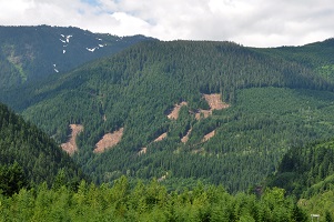
Examples of block shaping are visible from the Coquihalla Highway.
Contact information
For enquiries about visual resource management in British Columbia, please contact us at: