Forest disturbance monitoring
Forests are subject to frequent changes due to natural and human-induced disturbances such as:
- Harvesting
- Fire
- Insects
- Disease
To capture such changes quickly and inexpensively, B.C.'s Forest Inventory Geospatial Applications (FIGA) team uses a variety of geospatial tools and techniques to produce interim strategic-level maps until a comprehensive inventory can be completed.
Harvest mapping
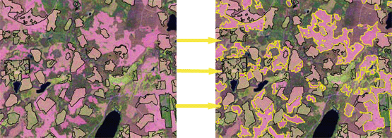
The remote sensing group assesses the how current the forest harvest mapping in B.C. is based on change detection techniques from Landsat satellite imagery.

Figure 1
The overall objective is to provide:
- Strategic-level data for cutblocks missing from Vegetation Resources Inventory (VRI)
- Gap analysis data for timber supply
Harvest mapping methodology
The workflow for the harvest-mapping project is as follows:
- Analysis by forest district
This first step divides multi-temporal Landsat images into subsets for each area of interest (district, TSA).
- Two-date Landsat imagery
Step two uses multi-spectral imagery from year two. The SWIR spectral band (band 5) calculates a ratio image between old band 5 and new band 5 to provide change information.
- Creation of ‘harvestable’ mask from VRI
Step three uses a simple query to divide the harvestable forest stands into subsets.
- Image pre-processing and analysis
Step four registers all imagery to a common database along with the ratio image. These data are then loaded into eCognition.
- eCognition processing, segmentation and classification
Next, this software segments and classifies the objects in the image.
- ArcGIS editing
Step six removes and edits polygons generated in error.
- Summary report by forest district
Finally, the summary report describes such metadata as input images, date and any extra comments relevant to the procedure and analysis.
Object-based analysis of forest disturbances
Traditional change detection studies used pixel-based analysis. Newly designed software, however, combines pixels with similar spatial and spectral characteristics into objects.
![]()
Figure 2
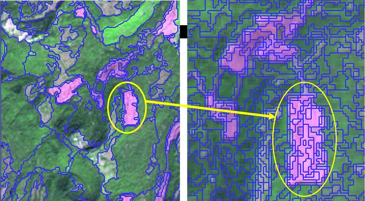
This object-level analysis creates useful statistics and other contextual information. Object-level analysis is particularly useful for multi-scale studies. Here, objects can be generated over all possible spatial resolutions presented in the input image. This allows the analyst to develop hierarchical associations between levels.
The following image uses multiple segments to refine the object edges and improve the actual perimeter of the harvested area.
Figure 3
Summary
Object-level analysis provides a fast and inexpensive way to map harvest areas. It is also a transferable and repeatable process. The final cutblock shapes can provide timely gap information anywhere in the province.
Contact information
For more information on Forest Forest Disturbance Monitoring, contact the Team Lead for Remote Sensing and Geospatial Applications.
geoffrey.quinn@gov.bc.ca

