
Vanderhoof Access Management Plan
The management of access in the Vanderhoof Land and Resource Management Plan (LRMP) area is one of the most explicit and highly prescribed values in the general management direction and resource management zones sections.
The focus of access management in the Vanderhoof LRMP is to provide guidance on maintaining access to crown land in a way that balances social, economic and environmental values. The Vanderhoof LRMP promotes a range of access types based on opportunities and values within the plan area.
Some of the access management issues the LRMP addresses include:
- The need to build, maintain or close access routes
- The tension between the need to accommodate industrial, commercial, and public uses while maintaining ecosystem integrity and fish/ wildlife values.
- The management of user group experiences and expectations on the same roads and trails (4WD vehicles versus horseback riding, hiking).
- The change to the physical environment and recreational experience from increased traffic volume.
The guidance in the Vanderhoof LRMP recognizes the fundamental need to maintain and promote industrial, recreational and public access, while acknowledging the impact that access management creates on land use planning values.
Plan & Plan Maps
The Vanderhoof Access Management Plan (AMP) maps and identifies access management areas for designated forest recreation opportunities, settings and experiences.
The plan provides choices and flexibility for implementation through the use of signage and various access management tool. Some of the highlights of the plan include:
- Management of road densities to maintain the integrity of recreational experiences for both motorised and non-motorised uses
- The identification of the permanent road network for long-term access to various recreational opportunities
- Identification of areas for specific recreation opportunities to provide certainty and reduce conflict between recreational users experiences and expectations
The Access Management Plan in the Vanderhoof LRMP was originally developed in 1998 and remains in effect to this day.
Implementation & Monitoring Direction
Decision Support Reports
Plan Type: Access Management Plan
Plan Status: Approved, non-legal policy plan (voluntary compliance)
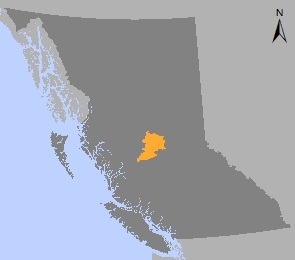
Plan Area: 1,387,973 hectares
Natural Resource Region: Omineca
Natural Resource District: Vanderhoof
Timber Supply Area: Prince George
Spatial Data
Related Links
Contact information
Contact the District Manager for the Stuart-Nechako Natural Resource District if you have questions about the Vanderhoof Access Management Plan.
250 567-6363