
Edge planning
In many communities, lengthy interfaces exist between agriculture and other land uses. Rapid population growth and historic land use patterns have accentuated the potential for land use conflict. Proper edge planning can mitigate these conflicts.
Shared Responsibilities
Municipal and regional district planning activities are particularly well suited to investigate the "where and how" questions associated with edge planning. Official Community Plans and Agricultural Area Plans can give direction to more detailed edge planning processes. The application of land use inventories in combination with geographic information systems (GIS), provide practical means to clearly understand the land use dynamics on both sides of the urban/agricultural edge. This will ensure solutions are based on ”'shared responsibility”.
Planning Tools
Planning tools provide local governments with opportunities to employ different methods to improve land use compatibility. Based on the principle of "shared responsibility", there are both urban and agriculture side tools. These tools include:
- The designation of Development Permit Areas for the protection of farming. This provision of the Local Government Act (LGA) allows for the application of buffering and other techniques on the ‘urban side’. (LGA Section 488(1)(c) and 491(6));
- With the approval of the Minister of Agriculture, the adoption of Farm Bylaws under LGA Section 552 by local governments may provide for opportunities on the ‘agricultural side’ to add flexibility in operational standards to achieve greater land use compatibility. To do so, local governments have become ‘regulated’ under LGA Section 553;
- Land Title Act provisions provide Subdivision Approval Officers opportunities to ensure that urban development next to farming is done in a manner that lessens the potential for conflict. An approving officer may refuse a plan of subdivision if adequate buffering on the ‘urban’ side of the interface is not provided or unnecessary roads are proposed to lead into the Agricultural Land Reserve. (LTA Section 86 (1)(c)(x) and (xi)).
To help promote compatibility between farmers and their neighbours, guidelines have been developed that will support local governments when addressing urban/agricultural compatibility issues - on both sides of the edge.
- Guide to Edge Planning (PDF)
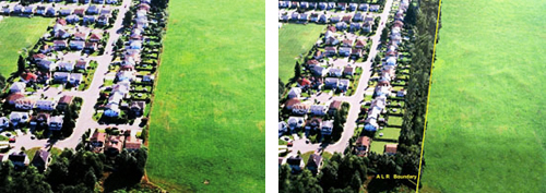
A Subdivision Design Example
Eliminating road endings directed at the Agricultural Land Reserve, and including adequate urban side buffering into a subdivision's design, can make significant improvements to land use compatibility. For example, the left photo below shows a subdivision beside agricultural land with a side road ending at the edge of the farm, with no buffering. The right photo shows the same subdivision with the road carrying on around the corner (no side road) and buffering installed between the backyard of the houses and the farm.
The Guide to Edge Planning provides useful information for local governments to promote compatibility along the agricultural-urban edge through land use planning initiatives such as official community plans or zoning bylaws.
![]()
Guide to Edge Planning (PDF)
Contact information
Regional Agri-teams are available across the province to provide direct assistance on matters concerning agricultural land.
Phone:
604-556-3001
1-888-221-7141
Email:
AgriServiceBC@gov.bc.ca