
Highway Maintenance Boundary Maps
Private contractors are responsible for maintaining provincial highways year-round. Each contract is for a specific service area.
- See Report a Problem for an interactive service area contacts map (zoom in for highways and communities)
- Provincial service area boundaries map (PDF, 1MB)
- List of contractors and contact information
- Highway maintenance specifications
Service Area Boundary Maps
These are maps of the service areas, showing details important to contractors.
- Service Area 1 - South Island (PDF, 5MB)
- Service Area 2 - Central Island (PDF, 9MB)
- Service Area 3 - North Island (PDF, 8MB)
- Service Area 4 - Howe Sound (PDF, 12MB)
- Service Area 5 - Sunshine Coast (PDF, 1MB)
- Service Area 6 - Lower Mainland (PDF, 19MB)
- Service Area 7 - Fraser Valley (PDF, 28MB)
- Service Area 8 - South Okanagan (PDF, 35MB)
- Service Area 9 - Kootenay (PDF, 17MB)
- Service Area 10 - Central Kootenay (PDF, 22MB)
- Service Area 11 - East Kootenay (PDF, 16MB)
- Service Area 12 - Selkirk (PDF, 7MB)
- Service Area 13 - Okanagan / Shuswap (PDF, 23MB)
- Service Area 14 - Nicola (PDF, 40MB)
- Service Area 15 - Thomson (PDF, 42MB)
- Service Area 16 - South Cariboo (PDF, 29MB)
- Service Area 17 - Central Cariboo (PDF, 21MB)
- Service Area 18 - North Cariboo (PDF, 17MB)
- Service Area 19 - Fort George (PDF, 10MB)
- Service Area 20 - Robson (PDF, 7MB)
- Service Area 21 - South Peace (PDF, 34MB)
- Service Area 22 - North Peace (PDF, 12MB)
- Service Area 23 - Nechako (PDF, 10MB)
- Service Area 24 - Lakes (PDF, 4MB)
- Service Area 25 - Bulkley Nass (PDF, 8MB)
- Service Area 26 - Skeena (PDF, 5MB)
- Service Area 27 - North Coast (PDF, 5MB)
- Service Area 28 - Stikine (PDF, 8MB)
Report a Problem
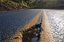
Report a problem such as pot holes, highway or bridge damage, sign damage, pavement marking, drainage problems, road debris or an animal carcass.
You can also report electrical problems like overhead signs, street lights, pedestrian lighting, and signals that are out or damaged.
Contact information
Contact ministry staff or contractors about highway infrastructure maintenance services or contracting.