
Weather Network Program
The B.C. Ministry of Transportation and Transit's Weather Network Program has a mission to provide effective environmental sensing services that support the safety and integrity of the provincial highways system.
B.C.'s weather monitoring network is built, operated and maintained by a team of environmental electronics technicians and IT systems experts who collect and share data with ministry and maintenance contractor personnel, the Meteorological Service of Canada, university based research programs, the Canadian Avalanche Centre and the travelling public through DriveBC.
The program provides real-time data from nearly 200 electronic weather stations throughout the province. This provides ministry staff with the information they need to make informed operational decisions about:
- winter road maintenance
- highway pavement temperatures for seasonal load restrictions
- potential avalanche hazards
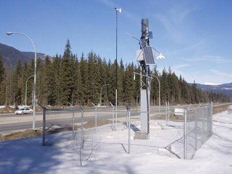
The network is made up of three different types of stations, each with different sets of instrumentation that supply data for operational decision-making.
Road Weather Stations
There are 99 road weather stations, located primarily in areas where weather conditions and local geography combine to create challenges for highway maintenance operations.
These stations collect atmospheric data as well as pavement temperature and condition data. From November 1 through March 31, site-specific road weather forecasts are issued twice daily for each station in the network to assist in planning highway maintenance activities.
Remote Avalanche Weather Stations
There are 67 remote avalanche weather stations in the province located in areas where the highways travel through avalanche terrain. They can be located at roadside, mid-mountain elevation, or mountain top, depending on the local requirements for avalanche forecasting.
Frost Probe Stations
There are 91 frost probe stations that measure pavement surface temperature and temperature beneath the road surface. Data is used to forecast the pavement’s strength loss during periods of extended thawing, primarily in the spring season. This enables ministry staff to impose appropriate load restrictions on load-sensitive highways in a timely fashion, which protects highway infrastructure from potential damage due to heavy industrial traffic during periods of low pavement strength.
Intelligent Transportation Systems (ITS)
The Weather Network Program has delivered a number of ITS projects, and this is expected to continue in the coming years.
- Weather monitoring on bridges enables the forecasting of snow and ice accumulations and assists in the planning of removal operations
- Dynamic message signs automatically display weather related safety messaging based on data from the weather stations
- Variable speed limit systems (currently in design phase) use pavement sensing stations to automatically provide an independent recommendation of the appropriate speed limit based on pavement surface condition, the degree of friction on the road surface and visibility
Database
Data from all these stations is as well as weather forecasts, avalanche hazard forecasts, avalanche occurrence data, explosives usage data and road closure information is maintained in a database. This data is available for operational use by ministry and maintenance contractor personnel.

Useful Links
Contact information
Contact us if you have questions about the Weather Network Program.