There’s never been a better time to Buy BC and support local growers, producers and the food we love right here in BC.
Explore Buy BC products

Notice of Work application mapping requirements
Requirements with every Notice of Work (NoW) application include maps and spatial files. Outlined below are the requirements, template files and written and video help guides.
Notice of Work (NoW) is an application made to the province to apply for a permit under section 10 of the Mines Act, to explore for mineral and coal and develop placer, quarry and aggregate resources.
Mineral and Coal Exploration Notice of Work Application Companion Guide (PDF, 14.2MB) provides details on how to prepare for, complete, and submit high-quality Notice of Work (NOW) applications. Mapping and geospatial requirements can be applied to placer, quarry, and sand and gravel NoW submissions.
Legislation
- Section 10(1) of the Mines Act states " ...as part of the application for the permit, there must be filed with an inspector a plan outlining the details of the proposed work...including the information, particulars and maps established by the regulations or the code."
- Health, Safety and Reclamation Code for Mines in British Columbia.
- Part 9.1.1 and 9.2.1(1) for mineral and coal exploration
- Part 10.1.2 for placer mining, sand and gravel pits, rock quarries and industrial mineral quarries
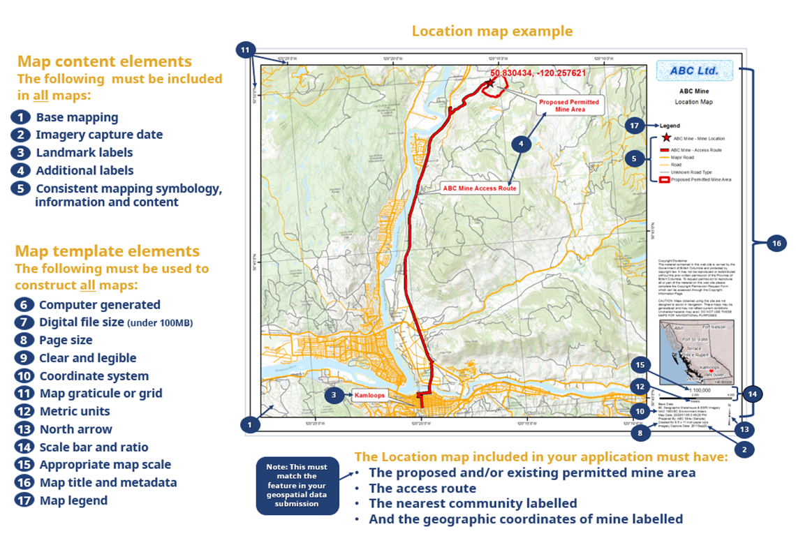
Map submission requirements
Mapping help guides
- Mineral and Coal Exploration Notice of Work Application Companion (PDF, 14.2MB) Section 1.4 ensure the map template and content elements are included in each map submitted in the permit application
- Mines Act Application iMapBC Reference Guide (PDF, 5.5MB) used to produce maps and geospatial files
- Create geospatial files and maps required for your Notice of Work application
- Computer generated using GIS specific software
- iMapBC reference guide (PDF, 4.7MB) uses a publicly available webmapping application
- iMapBC template project file - Section 2.2 in the reference guide
- iMapBC print template - Section 3.5 in the reference guide
- iMapBC reference guide (PDF, 4.7MB) uses a publicly available webmapping application
- Digital file size and resolution
- Size under 100MB
- Resolution 300DPI or lower
- PDF type preferred
- Page size
- Full-page maps
- 8.5x11 inches, preferred
- Clear and legible
- Labels, geospatial features, shading and colour coding must maintain legibility if printed in black and white
- Coordinate system and map graticule/grid
- NAD 1983 BC Environment Albers, preferred
- UTM
- Metric units
- E.g. elevation contours in metres
- Disturbance areas in hectares
- North arrow, true north pointing to top of page
- Map scale to show required map features
- Consider using overview maps
- Metric units
- E.g elevation contours in metres
- Disturbance areas in hectares
- North arrow, true north pointing to top of page
- Scale bar and ratio
- Use whole numbers such as 1:2000 or 1:5000, not 1:1567
- Map title and metadata
- Title or Permit Map
- Figure number
- Company/affiliation
- Permit number
- Mine number
- Base mapping source, download date
- Map creation date
- Geospatial data sources
- Coordinate system and projection
- Map legend
- Utilize legend over labels
- Base mapping
- Hill shade
- Orthophoto/imagery
- TRIM
- Road map
- Imagery capture date
- Landmark labels
- Significant landmarks such as towns, cities, roads, rivers or lakes
- Label all landmarks referenced in an application
- Additional labels
- Label and features reference in an application
- Mapping symbology
- Use consistent symbology across map submissions
- Consistent mapping information and content
- Use consistent mapping features across all map submissions
Maps required
Map |
Application required on |
|---|---|
|
All applications |
|
|
|
|
Sand and gravel applications |
|
|
|
| Additional Maps: | |
|
If necessary |
Items required on each of these maps:
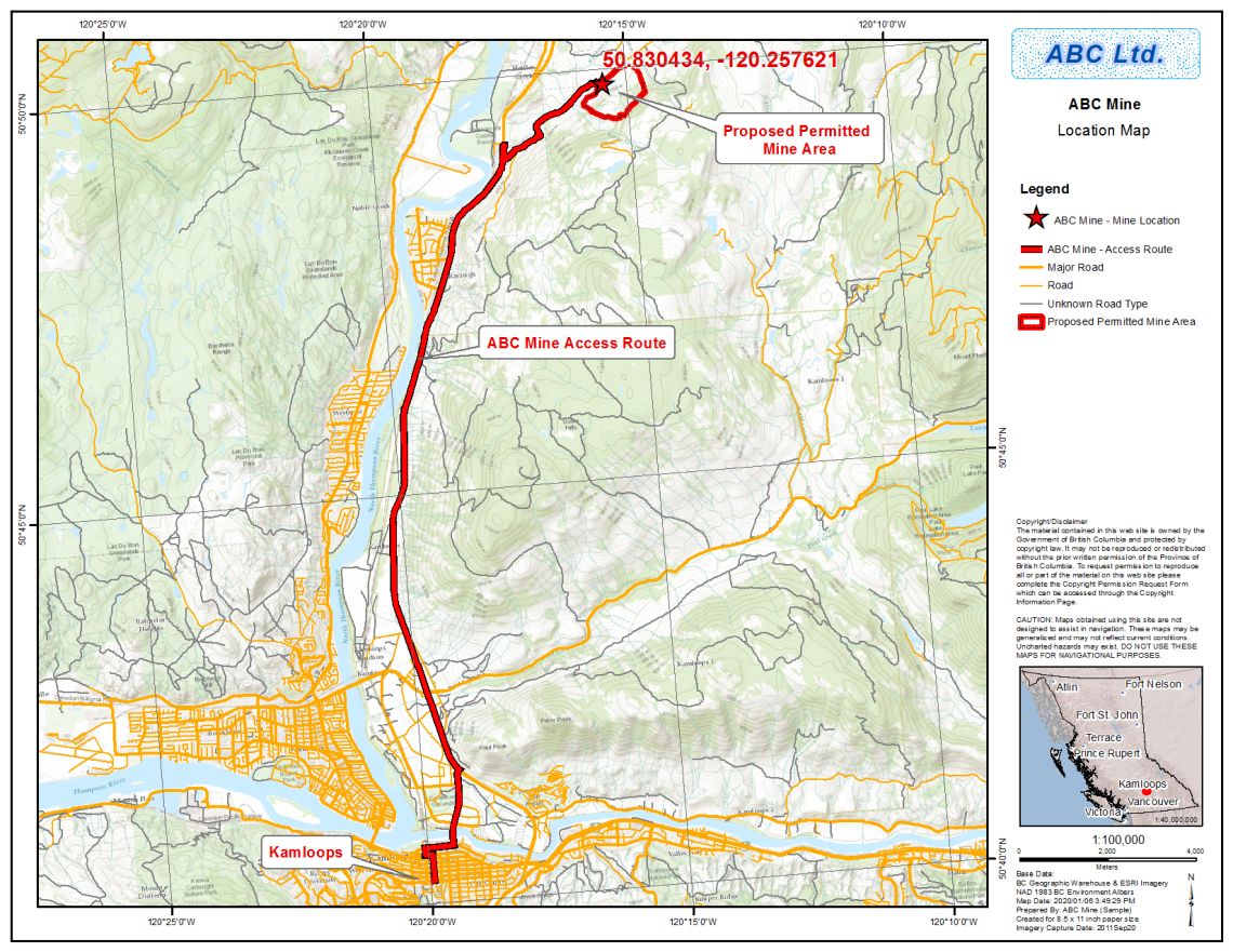
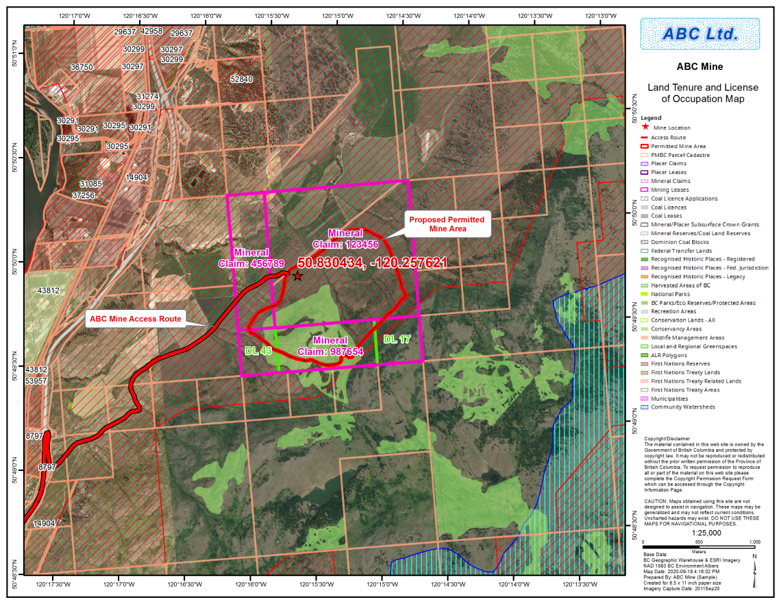
- Appropriate base mapping for understanding where the general location of the mine is in relation to communities/highways/landmarks
- A labeled point location of the mine with its coordinates (same as the Geographic Coordinates of Mines Latitude and Longitude in the application form)
- A labelled polygon representing the proposed and/or existing permitted mine area
- A labelled access route highlighting the exact directions to the site
- The nearest service community labelled with name
See section 3 of the iMapBC reference guide (PDF, 4.7MB)
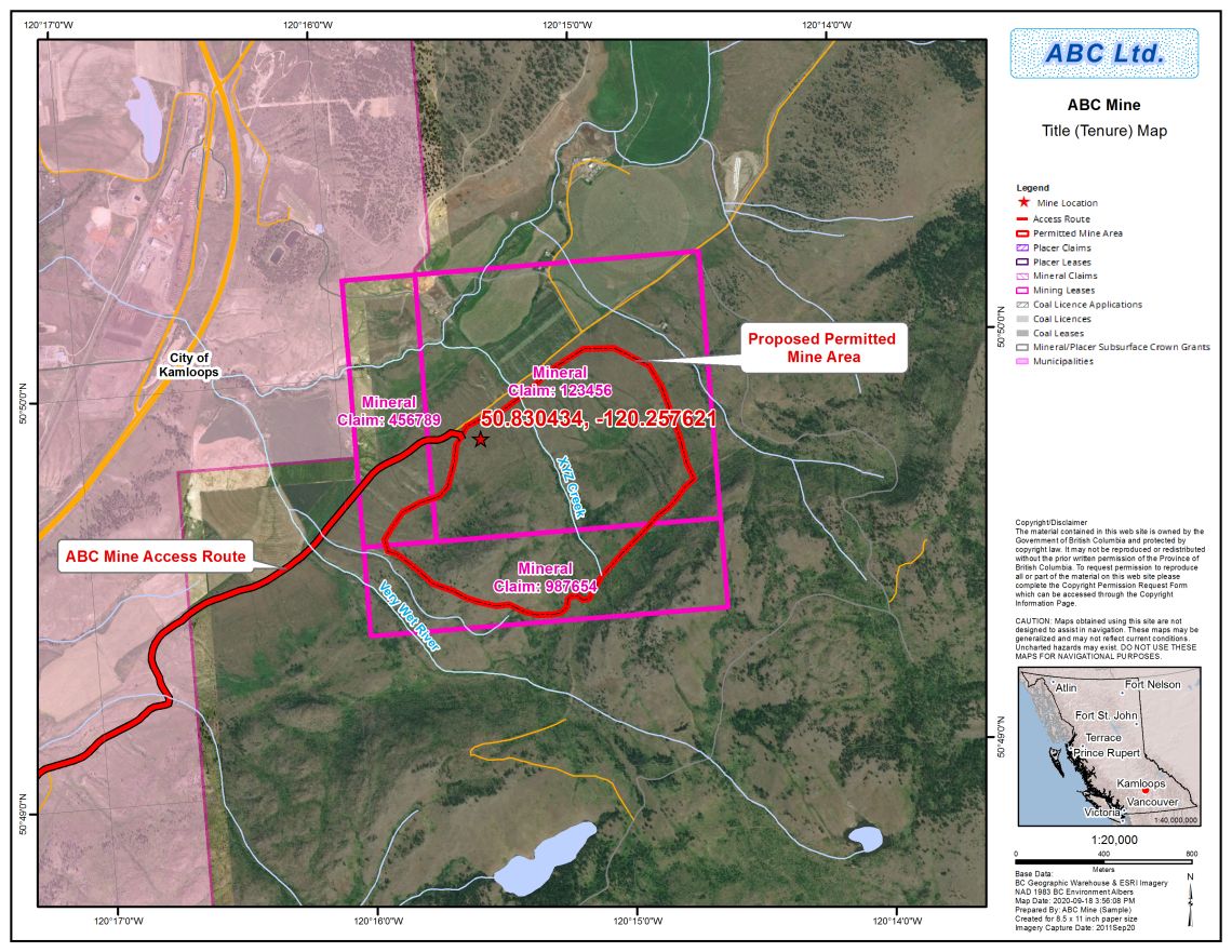
- Mineral, placer, or coal title(s), including crown grant(s), and indicate ownership
- Proposed and/or existing permitted mine area
See section 4 of the iMapBC reference guide (PDF, 4.7MB)
- Land title(s) and/or licence(s) of occupation in and surrounding the site, and indicate ownership
- Proposed and/or existing permitted mine area
See section 5 of the iMapBC reference guide (PDF, 4.7MB)
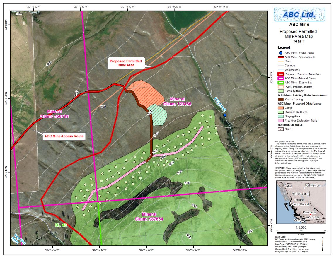
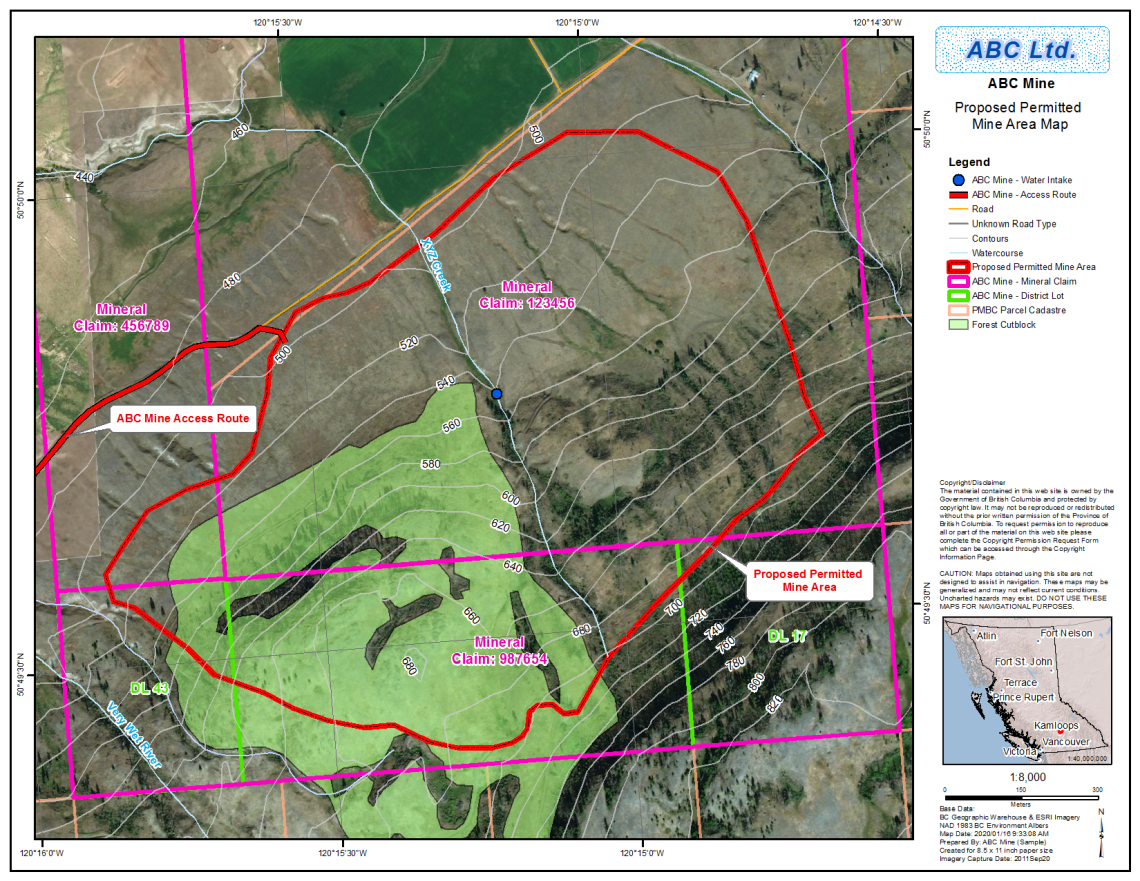
Mineral/coal exploration, and placer applications:
- Proposed and/or existing permitted mine area
- same as proposed and/or existing MYAB area(s)
- Site specific proposed disturbance and reclamation activities
- separate map needed for MYAB Year 1 program
- Existing disturbance and reclamation activities
- Elevation contours in metres
See section 6 of the iMapBC reference guide (PDF, 4.7MB)
MYAB Year 1 program, example
Sand and gravel, industrial mineral quarry, and bulk sample applications:
- Proposed and/or existing permitted mine area
- Site specific proposed disturbance and reclamation activities, including phased mining activities and progressive reclamation
- Existing disturbance and reclamation activities
- Elevation contours in metres
- Excavation setbacks as per HSRC 10.5.8 or 10.5.11
- Cross and long section traces
- Appropriate base mapping for understanding where the general location of the mine is in relation to communities/highways/landmarks
- Location and extent of the larger scale maps included in the application
See section 7 of the iMapBC reference guide (PDF, 4.7MB)
Geospatial data submission requirements
Geospatial data file elements
All notice of work geospatial data submissions must:
- Be identical in geographical shape, size and location to the features on submitted maps
- Be in polygon format (not lines or points)
- Include required geospatial features
- Have an accepted geospatial file type
- Follow naming standards
Geospatial features to submit with your notice of work application:
- Permitted Mine Area (PMA)
- The permitted mine area is the footprint/boundary of the entire work program. This boundary must contain all mine infrastructure and disturbance areas.
- Must be submitted as one polygon feature (multipart or singlepart)
- Disturbance areas
- All mining activities proposed/existing including access roads and trails (existing, modified, and new), trenches and stockpiles, drill pads/laydowns, and heli pads etc.
- Reclamation areas
- All reclamation activities such as revegetation to reclaim areas affected by mining
Data dictionaries for NoW spatial data submissions
Adding attributes to your spatial data submission? Reference the data dictionary in Appendix 2 of the Mines Act application iMapBC Maps and Data Creation reference guide (PDF 5.5MB) to review the structure and codes used for mining geospatial data submissions.
Geospatial file types
Acceptable geospatial filetypes to accompany your NoW submission: (see file naming standards)
- Shapefiles: must include the following (4) files
- [your_filename].shp
- [your_filename].shx
- [your_filename].dbf
- [your_filename].prj
- Google Earth: [your_filename].kml or [your_filename].kmz
- Geomark: URL
Projection for shapefile submission is NAD83/BC Albers (EPSG:3005).
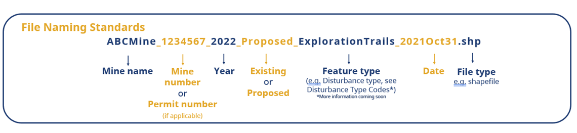
File naming standards
The following naming standard is preferred to allow for consistency and increase efficiencies in the permitting process.
MineName_MineNumber/PermitNumber_Year_Existing/Proposed_Featuretype_Date(YYYYMonDD).File_extension
Permitted mine area file naming example using a shapefile:
ABCMine_1234567_2022_Proposed_PermittedMineArea_2021Oct31.shp
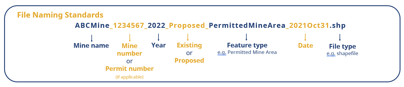
Disturbance type file naming example using a shapefile:
ABCMine_1234567_2022_Proposed_ExplorationTrails_2021Oct31.shp