
Sea to Sky Land and Resource Management Plan
The Sea to Sky Land and Resource Management Plan (LRMP) was initiated in 2001 to provide greater certainty for local economic development and the long-term sustainability of ecological, social and cultural values in the Sea to Sky plan area.
The plan was developed in several stages. Recommendations by a multi-sector planning forum, with contributions from local government representatives, were used to develop a consultation draft. Government-to-government land use agreements were negotiated with several local First Nations to harmonize the consultation draft with their land stewardship interests and/or land use plans. The consultation draft was revised to incorporate the land use zoning and management direction specified in these agreements, and then was shared with the public. The final Sea to Sky LRMP was approved by government in 2008.
In 2009, the plan was amended to include non-commercial winter recreation zones. The plan was also revised for administrative reasons later that year. In 2010, the plan was amended to reflect a government-to-government agreement with the Lil’wat Nation that resolved a land use conflict in the Mkwal’ts Nt’akmen (Ure Creek Area), and the subsequent establishment of the new Mkwal’ts Conservancy.
In 2011, 45 wildland areas were established in the Sea to Sky LRMP area. Objectives for First Nations cultural places, First Nations cultural management areas, floodplain management areas, and riparian areas were also legally established through a Land Use Objectives Regulation order. This order was amended in 2013 to include an additional cultural place identified by the Lil’Wat Nation.
Agreements with First Nations
- Partnership Agreement to Develop an Integrated Land and Resource Management Plan for the Indian River Watershed between the Tsleil-Waututh Nation and the Province of British Columbia - December 16, 2005 (PDF, 1.0MB)
- Strategic Land and Resource Management Planning Agreement between In-SHUCK-ch Nation and the Province of British Columbia - July 6, 2007 (PDF, 2.3MB)
- Squamish Nation Land Use Planning Agreement (Phase 2) between the Squamish Nation and the Province of British Columbia – 2025 (PDF 17.9 MB)
- Agreement on Land Use Planning Between the Squamish First Nation and the Province Of British Columbia - July 26, 2007 (PDF, 2.3MB)
- Land Use Planning Agreement Between the Lil’wat Nation And the Province Of British Columbia - April 11, 2008 (PDF, 2.2MB)
- Agreement Regarding the Mkwal'ts Nt'akmen (Ure Creek Area) between the Lil'wat Nation and the Province of British Columbia - April 22, 2010 (PDF, 2.1MB)
Legal Direction
- Sea to Sky Wildland Area Order - effective Mar 11, 2011 (Order-In-Council 0109-2011)
- Objectives for the Sea to Sky LRMP Area - Consolidated Order (PDF, 4.7MB)
- Notice of Public Permission Rescission – Winter Non-Motorized Recreation Zoning in the Sea to Sky LRMP Area - effective Dec 19, 2023 (PDF, 6.4MB)
- Maps (FTP)
- 3D Map of Non-Commercial Winter Recreation Zones – Including non-motorized zones and non-motorized with air access zones - 2023 (KMZ, 0.6MB)
- Note: Geobrowser (e.g. Google Earth or ArcGIS Explorer) required to view this file.
Additional Management Direction
Implementation Monitoring
Socioeconomic & Environmental Assessments
Other Decision Support Reports
- Forest Tourism Opportunities Study For Squamish Forest District & In-Shuck-Ch / N’quat’qua Statement Of Intent Area -2000 (PDF, 6.9MB)
- Community Water Supply Systems in the Sea to Sky LRMP Area - 2001 (PDF, 19.5MB)
- Sea to Sky Timber Harvesting & Processing Employment Survey - 2006 (PDF, 0.2MB)
- Recommendations for the Management of Winter Backcountry Recreation in the Lillooet River Drainage and the Sea to Sky LRMP Area - 2008 (PDF, 1.0MB)
Plan Status: Approved, some objectives legally established
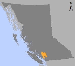
Plan Area: 1,098,514 hectares
Natural Resource Region: South Coast
Natural Resource District: Sea to Sky
Timber Supply Area: Soo