Stuart-Takla Fish-Forestry Interaction Project
The Stuart-Takla Fish-Forestry Interaction Project (STFFIP) was initiated in 1990 from the recognition that knowledge of interactions between forest harvesting and aquatic habitats was limited for the interior of British Columbia.
At the time, forestry guidelines and regulations for the protection of fish and fish habitat were largely based on research conducted in coastal watersheds. This research significantly improved both scientific knowledge and management capability for mitigating effects of logging on aquatic habitats. However, there are significant differences in physical and biological aspects between coastal and interior watersheds that could affect functional relationships between forestry and fisheries and their responses to logging disturbances. This uncertainty about the applicability of coastal forest management practices to interior forests was one of the primary driving forces behind the creation of the STFFIP.
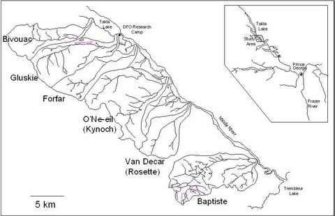
The STFFIP was sited in the northernmost watersheds of the Fraser River basin in north-central British Columbia. Initially, four similar salmon-bearing tributaries and their watersheds were selected for the study. These were subsequently complemented by the addition of headwater streams (bankfull width less then 1.5m) to the study. Small streams received little riparian buffer protection under B.C. forest practices legislation and little was known about the ecological roles of headwater streams. Variable-retention riparian buffer strips had been used in the forest harvesting industry; however their efficacy for maintaining natural stream and riparian functions had not been well documented.
As an interdisciplinary study, the STFFIP incorporated hydrology, forestry, fisheries science and aquatic ecology expertise. Research activities included monitoring and assessment of stream and groundwater hydrology and thermal dynamics, streambed composition and mobilization, water quality, suspended sediment dynamics, local meteorology, incubation environments, predator-prey interactions, primary productivity, invertebrate production and patterns, large woody debris (LWD) surveys, and the distribution, movement, growth, and habitat use of resident and migratory salmonids.
Due to its multidisciplinary design, the STFFIP involved numerous researchers from various organizations including the Canadian Department of Fisheries and Oceans (lead agency), the B.C. Ministry of Forests and Range, the B.C. Ministry of Environment, Environment Canada, the Canadian Wildlife Service, the University of Northern British Columbia, the University of British Columbia, and Simon Fraser University. Collaboration of a forest industry partner (Canadian Forest Products Limited) was an important component of the study. The early involvement of the local First Nations bands in the STFFIP was also imperative. The study watersheds are part of the traditional territories of the Tl'azt'en Nation. Tl'azt'en band members, as well as members from other First Nations bands of the Carrier Sekani Tribal Council, were involved in many areas of the research.
Study site
The four spawning creeks (Bivouac, Forfar, Gluskie and O'Ne-ell Creeks) are fourth-order and arise in the Hogem Range of the Omineca Mountains within British Columbia's Sub-boreal Spruce (SBS) biogeoclimatic zone. They are tributary to the Stuart Takla system, which comprises Takla, Trembleur and Stuart Lakes. The surrounding mature forests are comprised primarily of hybrid white spruce (Picea glauca X engelmannii), subalpine fir (Abies lasiocarpa) and lodgepole pine (Pinus contorta).
The study stream watersheds are largely undisturbed; Gluskie and Bivouac had minimal harvesting to control a beetle outbreak, and a logging road intersects each stream 500 to 1700 metres upstream of their mouths. The four streams flow Northeast into Takla Lake or its outflow, Middle River, at an elevation of 700m. Watershed areas range from 36 to 75km2 with main channel lengths of 15 to 20km and stream bankfull widths of 9 to 15 metres. The lower 3 to 4 kilometres of the watersheds are low-gradient (0.5 to 2.0%), with large alluvial fans near their mouths.

