
Revelstoke Land Use Plan
In 1992, the B.C. government directed that a strategic land use plan be prepared to identify a comprehensive and integrated vision for land and resource use in the Kootenay-Boundary region. Recommendations resulting from two land-use tables were used to develop the East Kootenay and West Kootenay-Boundary Land Use Plans released in 1995. The latter plan included a commitment to provide the community of Revelstoke with the opportunity to advise on specific resource management guidance for the Revelstoke District. The Revelstoke and Area Land Use Planning Final Recommendations were completed in 1999.
In 2005, selected recommendations for the Revelstoke Resource Management Zone were established as a higher level plan under the Forest Practices Code of B.C. Act. Two orders varying the objectives have been approved since 2009. The Caribou habitat management objective (objective 3) was cancelled in 2009 to eliminate duplication or conflicts with the 2007 Mountain Caribou Recovery Implementation Plan, as well as caribou ungulate winter range and wildlife habitat areas designated under the Government Actions Regulation of the Forest & Range Practices Act.
Legal Direction
| Order | Effective Date |
Order Establishing Resource Management Zones and Resource Management Zone Objectives Within the Area Covered By the Revelstoke Land Use Plan as a Higher Level Plan (PDF, 4.1MB)
|
25-Mar-2005 |
| Order Cancelling Objective 3 (Caribou) (PDF, 0.5MB) | 12-Feb-2009 |
| Order Amending Objectives 1 (Biodiversity) and 2 (Old and Mature Forest) (PDF, 7.3MB) | 22-Dec-2011 |
Retired Land Use Plan
Plan Status: Approved, legally established
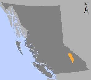
Plan Area: 833,125 hectares
Natural Resource Region: Kootenay-Boundary
Natural Resource District: Selkirk (formerly Columbia)
Timber Supply Areas: Revelstoke, Cascadia
Tree Farm Licenses: 55, 56
Contact information
Contact us if you have questions about land and resource use planning in the Kootenay-Boundary region.