Metro Vancouver Regional District (MVRD)
High Precision Network (HPN) 2019 Horizontal Refresh
Bulletin: October 22, 2019
In 2005, the results of the MVRD HPN campaign were published on the MASCOT database. Since that time, some of those HPN Geodetic Control Monuments (GCMs) have shifted, been disturbed or destroyed. Destroyed HPN GCMs have been replaced and, over a 3-year period (2016-2019), a refresh survey has been completed to arrive at new coordinates for GCMs throughout the network.
As a result of this survey campaign, the horizontal coordinates of 380 existing GCMs will be updated and 27 new GCMs will be introduced. GeoBC proposes to publish the results in December 2019. On average, the magnitude of change is 10mm, and the median change is 8mm. There are some HPN GCMs that have moved by up to ~100mm. The HPN campaign included new observations to three classes of GCMs; 318 Class A, 42 Class B, 20 Class C. All of these GCMs will be updated to Class A as a result of this refresh.
Click here to see a map (with GCMs labelled) of the coordinate updates for the GCMs that were observed as a part of the HPN campaign. As well click here to see a map without GCMs labelled. The magnitude (units are in mm) and direction of the coordinate updates are shown by green shift vectors for Class A GCMs, and blue shift vectors for GCM Classes B or C. The 7 constraint stations are shown as magenta coloured squares. The black and red coloured triangles represent the location of 27 new GCMs and 380 existing monuments, respectively. Click here for a preliminary listing of the adjusted coordinates resulting from the 2019 refresh. End users are encouraged to review and test the refreshed coordinates prior to being officially published. Please contact GeoBC if any problems are found within the proposed HPN refresh: GeoBCinfo@gov.bc.ca
Important Sections on MASCOT Long Forms to Review
When selecting GCMs for project referencing, surveyors are reminded to review Section 10 of MASCOT long forms titled “Current Marker Classification Comment” as shown in Figure 1. This section will provide the date of the latest coordinate revision and the reasons for those updates. The coordinates of many GCMs that have been relied upon for many years will be changing as a result of this refresh. Surveyors are therefore advised to review the changes to GCMs in order to acquire the necessary information needed to make decisions on how to handle issues related to consistency of datasets prior to and after the 2019 HPN refresh.

Figure 1: HPN Refresh information shown on MASCOT long forms
GCMs that are a part of this refresh and/or part of the previous (original) HPN campaign but now destroyed or not resurveyed, will be identified as “HPN-MVRD” in the “Other” field within the “Historical/Other Marker Names” section of MASCOT long forms as shown in Figure 2 below.

Figure 2: Location of HPN Identifier on MASCOT Long Forms
Adjustment Details
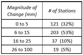
The updated horizontal coordinates resulting from this network adjustment have been compared with the existing published coordinates on the MASCOT database. Table 1 shows results of this comparison.
Table 1: Coordinate Updates of HPN GCMs in the MVRD

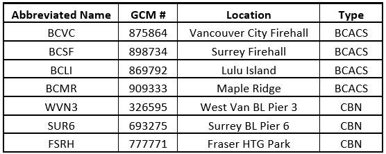
Table 2: 2019 HPN Refresh Constraint Stations

BCLC (Langley City) was not constrained in the adjustment and the coordinates will be updated by 12mm. All stations with shift magnitudes greater than 15mm were reviewed for possible stability issues. Arriving at definitive conclusions proved to be difficult and therefore GeoBC is hesitant to cast unnecessary doubt on GCMs without sufficient evidence to prove instability at a given GCM. A majority of these GCMs have likely only been momentarily disturbed (at some point between 2004 and now), and there is no evidence to suggest that they are perpetually unstable. As well, users should be aware that past and present adjustments both contain an error component (as is present in all observation sets) and therefore coordinate changes should not be mistaken to be entirely representative of station movement. There are eight GCMs that show evidence of perpetual instability and their long forms will be flagged as “Anomalous” as shown in Figure 3. The GCMs to be assigned with the anomalous condition are as follows: 1511, 21139, 394825, 446658, 607093, 758508, 762716, and 901199.

Figure 3: Anomalous status to be assigned to GCMs with potential stability issues
MASCOT coordinates in the MVRD are referenced to NAD83 (CSRS) Version 4 Epoch 2002, which is synonymous with NAD83(CSRS) 4.0.0.BC.1.GVRD as shown on MASCOT long forms. GeoBC plans to update this datum tag for all GCMs in the MVRD to NAD83(CSRS) 4.0.0.BC.1.MVRD in the near future. This particular change may not occur simultaneously with the coordinate updates.
Make note that the estimated uncertainty of published coordinates on MASCOT, as shown in Figure 4, is stated at 68% confidence for their respective northing & easting components. The standard deviations of those components (resulting from the latest refresh adjustment) will range from 5mm to 13mm. GeoBC recommends that users scale these uncertainties up to 95% confidence in order to arrive at more realistic values.

Figure 4: Estimated Standard Deviation of Published Coordinates
