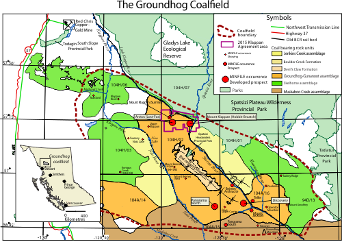
The Groundhog Coalfield
NTS Map Sheets: 93E/04; 94D/12,13; 104H/01,02,03,06,07
View IC2016-05 for more information on the Groundhog Coalfield
The Groundhog coalfield is in the Skeena Ranges of northwestern British Columbia, a 30 by 80 km ovoid extending southeastwards from the headwaters of the Klappan and Little Klappan rivers to Groundhog Mountain. Coal occurs in several units of the Bowser Lake Group, which consists of Jurassic and early Cretaceous marine and non-marine strata deposited in Bowser Basin. There are up to 25 coal seams, which range in thickness up to 7 metres. The Groundhog coalfield contains Canada’s most significant deposits of anthracite, with estimated potential resources of 37 billion tonnes of coal (Ryan and Dawson1993). Groundhog coalfield coals have moderate to high purity and are low in sulphur.
Anthracite is relatively rare, making up about 1% of all coals globally. Of all coals, anthracite has the highest heat content per unit weight. The most significant market for anthracite is as PCI (pulverized coal injection) coal, which is used in making steel.
The area is extensively folded. The developed coal prospects lie in the northwest-trending Biernes synclinorium.
Coal exploration in the Groundhog coalfield began in the late 1800s. In the late 1970s and 1980s several oil companies extensively explored the Klappan, Discovery and Panorama areas.
In the early 2000s the Geological Survey of Canada and British Columbia Geological Survey mapped the Bowser basin and produced 1:50 000 scale geological maps for the entire Groundhog coalfield area (Evenchick. and Thorkelson, 2004).
Shell Canada explored the Groundhog's coalbed methane potential from 2004 until 2012, when the company relinquished its tenure as part of an agreement between Shell, the British Columbia Government, and the Tahltan First Nation.
In 2015, the Province of British Columbia and Fortune Minerals announced an agreement in which the Province would acquire tenure in the Mount Klappan area to facilitate work with the Tahltan Nation on a shared vision for the area. The tenure holder, Fortune Minerals holds a 10 year option to repurchase the licenses at the original price. The agreement area is outlined in pink on the map.
A large coal reserve was established in 2017 over most of the western side of the coalfield. No coal exploration or mining is permitted in the reserve. See Mineral Titles Online for current coal reserve boundaries.
Selected references
- Buckham, A.F. and Latour, B.A., 1950. The Groundhog Coalfield, British Columbia. Geological Survey of Canada, Bulletin 16
- Cookenboo, H.O. and Bustin, R,M., 1989. Stratigraphy of Coal Occurrences in the Bowser Basin. Geological Fieldwork 1989, B.C. Ministry of Energy, Mines and Petroleum Resources, Paper 1990-1, pages 473-477.
- Cookenboo, H.O. and Bustin, R,M., 1990. Coal-Bearing Facies in the Northern Bowser Basin. Geological Fieldwork 1990, B.C. Ministry of Energy, Mines and Petroleum Resources, Paper 1991-1, pages 415-418.
- Evenchick, C.A., Mustard, P.S., Greig, C.J., Porter, J.S., and McNeill, P.D.,2000. Geology, Bowser Lake, British Columbia; Geological Survey of Canada, Open File 3918, Scale 1:250 000.
- Evenchick, C.A. and Thorkelson, D.J., 2004. Geology, Spatsizi River, British Columbia; Geological Survey of Canada, Map 2040A, Scale 1:250 000.
- Evenchick, C.A., Ritcey, D.H., Mustard, P.S., and McMechan, M.E., 2007. Geology, Toodoggone River, British Columbia; Geological Survey of Canada, Open File 5570, Scale 1:125 000.
- Gilchrist, R.D., 1978. Groundhog Coalfield. Geological Fieldwork 1978, B.C. Ministry of Energy, Mines and Petroleum Resources, Paper 1979-1, pages 84-85.
- Koo, J, 1983. The Telkwa, Red Rose and Klappan Coal Measures in Northwestern British Columbia. Geological Fieldwork 1983, B.C. Ministry of Energy, Mines and Petroleum Resources, Paper 1984-1, pages 81-90.
- Koo, J, 1985. Geology of the Klappan Coalfield in Northwestern British Columbia. Geological Fieldwork 1985, B.C. Ministry of Energy, Mines and Petroleum Resources, Paper 1986-1, pages 225-228.
- Koo, J, 1986. Geology of the Klappan Coalfield in Northwest British Columbia; B.C. Ministry of Energy, Mines and Petroleum Resources, Open File 1986-3.
- MacLeod, S.E. and Hills, L.V., 1990. Conformable Late Jurassic (Oxfordian) to Early Cretaceous Strata, Northern Bowser Basin, British Columbia: A Sedimentological and Paleontological Model; Canadian Journal of Earth Science, Volume 27, pages 988-998.
- Moffat, I.W. and Bustin, R. M., 1993. Deformational History of the Groundhog Coalfield, Northeastern Bowser Basin, British Columbia; Styles, Superposition and Tectonic Implications; Bulletin of Canadian Petroleum Geology, Volume 41, pages 1 to 16.
- Ryan, B.D. and Dawson, F.M., 1993. Coal and Coalbed Methane Potential of the Bowser Basin, Northern British Columbia; B.C. Ministry of Energy, Mines and Petroleum Resources, Open File 1993-31.
- Schroeter, T.G. and White, G.V., 1984. The Sustut Coal Measures. Geological Fieldwork 1984, B.C. Ministry of Energy, Mines and Petroleum Resources, Paper 1985-1, pages 285-290.

