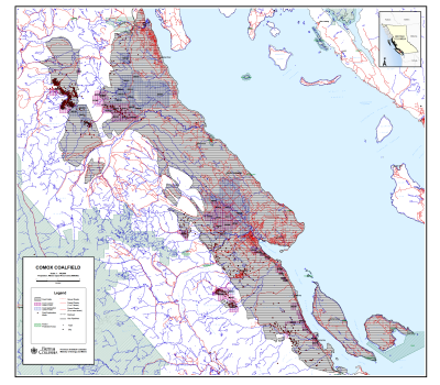
The Comox Coalfield
NTS Map Sheets: 92K/,15,14,11,10,07,03
The Comox Coalfield (1:100,000) (PDF, 2.4MB)
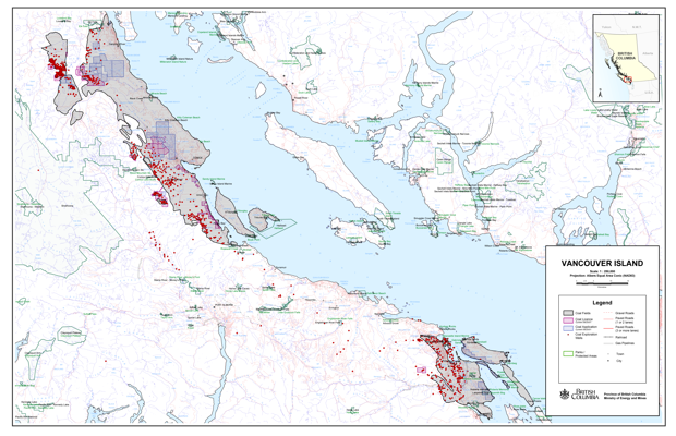
The Nanaimo and Comox Coalfields (1:250,000) (PDF, 7.3MB)
The Comox coalfield, on the central east coast of Vancouver Island, covers approximately 2,000 square kilometres from Campbell River to Fanny Bay. The Comox Formation of the Upper Cretaceous Nanaimo Group contains four major seams with a cumulative thickness ranging from two to eight metres. The Comox Formation dips eastward with the regional dip complicated by broad folds, thrusts and normal faults.
The Comox Coalfield produced 18.6 million tonnes of high-volatile A and B bituminous coal from 1888 to 1953. Underground mining took place on three of the four principal seams in the Comox Formation. Currently, the Quinsam mine in the Comox coalfield is the only operating coal mine on Vancouver Island. This underground room and pillar mine produces several hundred thousand tonnes per year of high-volatile A bituminous thermal coal. The Comox coalfield is estimated to contain approximately 0.7 trillion cubic feet of natural gas.
Selected references
- Bickford, C.G.C., Hoffman, G., and Kenyon, C., 1988. Coal Measures Geology of the Quinsam Area. Geological Fieldwork 1988, B.C. Ministry of Energy, Mines and Petroleum Resources, Paper 1989-1, pages 559-563.
- Bickford, C.G.C., Hoffman, G., and Kenyon, C., 1989. Geological Investigations in the Coal Measures of the Oyster River, Mount Washington and Cumberland Area, Vancouver Island. Geological Fieldwork 1989, B.C. Ministry of Energy, Mines and Petroleum Resources, Paper 1990-1, pages 431-437.
- Cathyl-Bickford, C.G., 1991. Geology and Energy Resource Potential of The Tsable River and Denman Island. Geological Fieldwork 1991, B.C. Ministry of Energy, Mines and Petroleum Resources, Paper 1992-1, pages 419-426.
- Cathyl-Bickford, C.G. and Hoffman, G.L., 1998. Geological maps of the Nanaimo and Comox Coalfields, B.C. Ministry of Energy and Mines, Open File 1998-7.
- Eastwood, G.E.P., 1977. Quinsam Area. Geology in British Columbia 1977-1981, B.C. Ministry of Energy, Mines and Petroleum Resources, pages 69-75.
- Eastwood, G.E.P., 1977. Quinsam Area, Vancouver Island. Geological Fieldwork 1977, B.C. Ministry of Energy, Mines and Petroleum Resources, Paper 1978-1, pages 55-56.
- Holuszko, M.E., Matheson, A., and Grieve, D.A., 1992. Pyrite Occurrences in Telkwa and Quinsam Coal Seams. Geological Fieldwork 1992, B.C. Ministry of Energy, Mines and Petroleum Resources, Paper 1993-1, pages 527-546.
- Kenyon, C., Cathyl-Bickford, C.G., and Hoffman, G., 1991. Quinsam and Chute Creek Coal Deposits (NTS (92/13,14). B.C. Ministry of Energy, Mines and Petroleum Resources, Paper 1991-3
- Matheson, A.H., 1989. Subsurface Coal Sampling Survey, Quinsam Area, Vancouver Island, British Columbia. Geological Fieldwork 1989, B.C. Ministry of Energy, Mines and Petroleum Resources, Paper 1990-1, pages 439-443.
- Ryan, B.D. and Dawson, F.M., 1993. Coalbed Methane Desorption Results from the Quinsam Coal Mine and Coalbed Methane Resource of the Quinsam Coalfield, British Columbia, Canada (92F/13,14). Geological Fieldwork 1993, B.C. Ministry of Energy, Mines and Petroleum Resources, Paper 1994-1, pages 215- 224.
- Ryan, B.D., 1994. Calcite in Coal from the Quinsam Coal Mine, British Columbia, Canada, Origin, Distribution and Effects on Coal Utilization. Geological Fieldwork 1994, B.C. Ministry of Energy, Mines and Petroleum Resources, Paper 1995-1, pages 243-260.
- Ryan, B.D., 1996. Coalbed Methane in the Comox Formation in the Tsable River Area, Vancouver Island. Geological Fieldwork 1996, B.C. Ministry of Employment and Investment, Paper 1997-1, pages 353-363.
- Van der Flier-Keller, E. and Dumais, S., 1987. Inorganic Matter Content and Specialized Element Potential of the Nanaimo and Comox Coalfields, Vancouver Island (92G,F,K). Geological Fieldwork 1987, B.C. Ministry of Energy, Mines and Petroleum Resources, Paper 1988-1, pages 435-439.


