Provincial Site Productivity Layer
New on the B.C. site productivity layer
The provincial site productivity layer Version 8.0 has been updated over the previous version (v7.0) with the inclusion of 8 new or revised units, as follows:
- An updated SIBEC crosswalk table was used to precisely map changes in BGC Unit and Site Series Codes
- Inclusion of Manning Park TEM, Coastal EBM TEM Phase 9, Naikoon Landscape, Ian Landscape Unit TEM, TFL 25 Block 5 and Block 2 – TEM Update, Khutzeymateen Provincial Park – TEM Update, Johnston LU – TEM Update, TFL 39 Namu– TEM Update
As with version 7.0, two different editions of the site productivity dataset are made available in version 8.0: one named “Site Prod with Approved PEM/TEM” that uses only the PEM/TEM datasets that have undergone and passed a third party accuracy assessment, or that used an Ecosystem Survey Intensity Level (ESIL) of 1 to 5 during the PEM or TEM mapping process, and another named “Site Prod with All PEM/TEM” which incorporates all of the PEM/TEM datasets, and which is available upon special request. See Appendices B and C in the technical document for a detailed list and maps of the PEM/TEM datasets used in each edition of the provincial site productivity dataset.
What is the site productivity layer project?
The provincial site productivity layer project was commenced in 2011 as a Land Based Investment Strategy (LBIS) funded project. This work has been an integral part of the Land Based Investment Strategy (LBIS) program needs and the Provincial Site Productivity Strategic Project Plan (2014 to 2016) developed by Forest Analysis and Inventory Branch (FAIB). LBIS requested FAIB to plan and lead the improvement of access to site productivity information as one of its key strategic goals over the 2010/11 to 2015/16 period. Successful completion of this work meets one of LBIS’s highest program goals since current and comprehensive site productivity information is a critical foundation piece for all sound forest management decisions and practices.
The version 8.0 update builds upon the previous years’ data and consist of a seamless site productivity layer with priority PEM and TEM data cleaned and loaded together with a biophysical model. As with the version 7.0 site productivity layer, the bio-physical model is used to fill-in any gaps where no PEM or TEM data having a reliable vintage or level of accuracy is available, or where SIBEC site index estimates were lacking. Data cleaning and loading focuses on filling information gaps in the higher LBIS priority units first and selected the most current PEM or TEM information available for these units.
Provincial site productivity layer documents
- Site Index Standard Operating Procedures (SOP) (revised 4.3 - 7th July 2014) [PDF 270KB]
- PEM/TEM-SIBEC and Biophysical Analysis Version 8.0 [PDF 3.5MB]
- Appendix C - Discrepancy Report [PDF 65KB]
- SI Validation report
Provincial site productivity layer coverage
(To view maps at larger scale, please click on images)
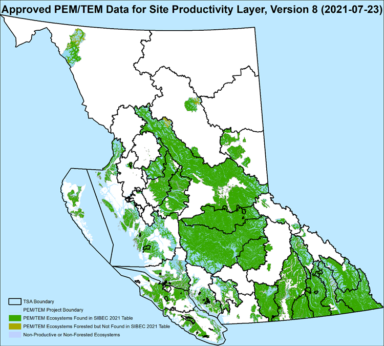
Approved PEM/TEM data for site productivity layer, version 8.0 (2020/21)
PEM/TEM data incorporated in the “Approved PEM/TEM Data for Site Productivity Layer, Version 8.0” edition of the Site Productivity dataset consists of only those PEM/TEM datasets that have passed a third-party accuracy assessment, or that utilized a suitable number of field sample sites during mapping process, typically ESIL levels 1-5. Higher intensity level field sampling conducted during the mapping process results in a greater degree of thematic map reliability.
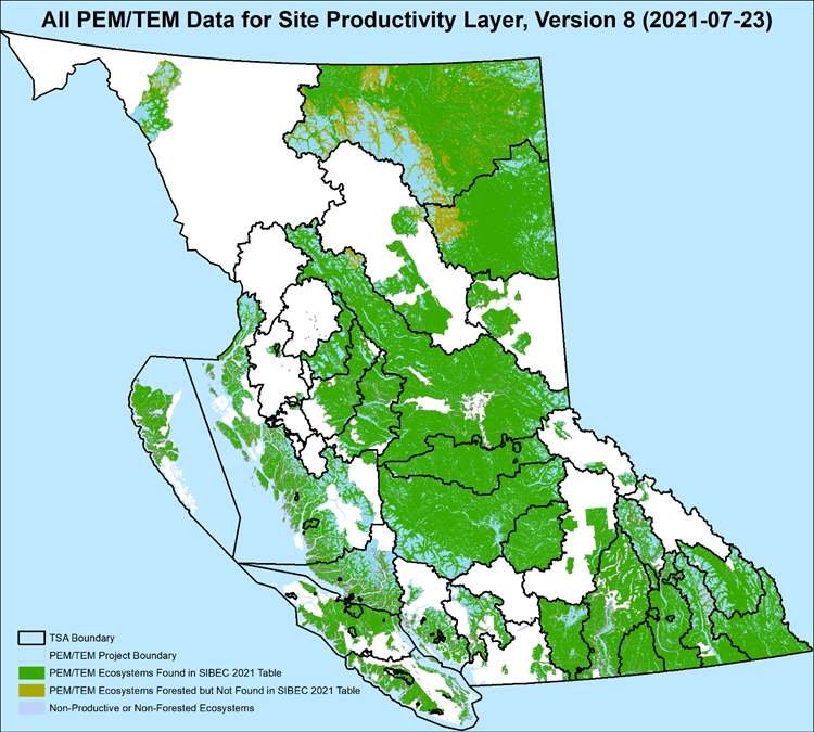
All PEM/TEM data for site productivity layer, version 8.0 (2020/2021)
PEM/TEM data coverage incorporated in the “All PEM/TEM Data for the Site Productivity Layer, Version 8.0” edition of the Site Productivity dataset consists of all available PEM/TEM datasets, including those with low or unknown accuracy. This map displays the study area boundaries of all known PEM/TEM projects regardless of accuracy assessment (AA) and/or ecosystem survey intensity level (ESIL). Note, AA has not been performed on all PEM/TEM data and the ESIL varies from project to project. This dataset is only available upon request.
Access to the database & PDF maps catalogue
Version 8.0 of the provincial site productivity data and corresponding PDF maps are now available for download by Timber Supply Area (TSA) through the Site Productivity Data Locator App.
Conditions on uses of this data
The information provided in this provincial site productivity layer is based on the best known and most current information as of July 30, 2021. All of the content is provided “as is” without warranty of any kind, whether expressed or implied. Under no circumstances will the Government of British Columbia be liable to any person or business entity for any direct, indirect, special, incidental, consequential, or other damages based on any use of this data. All of the data used in the production of the site productivity layer has been reviewed and any known errors corrected, however end users should always use this information in conjunction with local knowledge and expertise. The information contained in this GIS layer is not intended to replace more accurate site-specific data, if available.
Catalogue of Adobe format maps of site index by species
For those tree species with a limited geographic distribution in BC, the site index coverage on the PDF maps will generally reflect this distribution. However, some maps may have low coverage for a species due to very limited site productivity data, specifically red alder (Dr), tamarack (Lt), whitebark pine (Pa) and grand fir (Bg).
Data catalogue
Site index by species data from the provincial site productivity layer (Ver. 8.0) can be accessed through the associated Data Catalogue
Contact information
For further information on the provincial site productivity layer please contact:
Pamela.Dykstra@gov.bc.ca


