Use of HTv2.0 Models for Height Derivation in British Columbia
August 2019
HTv2.0 is a height transformation model that was created by modifying a gravimetric geoid model (CGG2000) to fit the historical CGVD28 tidal/levelling datum across Canada. It can also be referred to as a hybrid geoid model. It allows GNSS-derived ellipsoidal heights (h) to be transformed to approximate CGVD28 orthometric heights (H). The original HTv2.0 model provides reasonable separations between the ellipsoid (in NAD83 CSRS) and the vertical datum (CGVD28) at Epoch 1997.0 along routes throughout BC where historic geodetic levelling and GPS observations have been made. Over time, glacial isostatic adjustment and tectonic plate motion have caused ellipsoidal heights to change. However, a fundamental characteristic of the CGVD28 datum is that published orthometric heights do not change with the terrain motion. Put another way, the CGVD28 datum moves with the aforementioned vertical displacements, such that published orthometric heights of GCMs remain constant over time. Variants of the HTv2.0 model are now available that align with the various CSRS epochs that are in common usage throughout Canada: Epochs 2002.0 and 2010.0. These new versions were derived from annual vertical velocities of the CSRS velocity model. All versions can be imported for use within NRCan's utility program GPS-H and they are also available via the NRCan online station reports for passive and active stations when CGVD28 is selected as a vertical datum.
The Effect of New Epochs of HTv2.0 in BC
Until recently, there has only been one HTv2.0 model publicly available: Epoch 1997.0 i.e. HTv2.0 (original) = HTv2.0 (1997). Circa 2005/06, GeoBC used HTv2.0 (1997) to derive the hybrid ellipsoidal heights, HCGVD28 + NHTv2.0 (1997), at all BCACS stations. Rather than basing the system off of true GNSS-derived ellipsoidal heights in NAD83(CSRS) Epoch 2002.0, the active control system was manipulated to best fit to the HTv2.0 model available at that time. As there are no plans to disrupt the BCACS in the near future, the best practice is to continue using HTv2.0 (1997) in conjunction with baseline connections to BCACS stations.
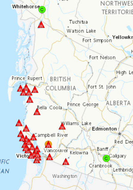
There are also other GNSS active control stations that are in common use throughout BC: the Western Canada Deformation Array (WCDA) and private network providers that are part of NRCan’s Real-time Network (RTN) Compliancy Program. Three dimensional coordinates for these active control stations can be obtained via the NRCAN Station Reports at any epoch, including Epoch 2002.0. Surveyors who reference their work horizontally to Epoch 2002.0 will have naturally been holding fixed the Epoch 2002.0 ellipsoidal heights of these stations as well.
 Figure 1: WCDA stations in BC
The best practice with respect to absolute CGVD28 height accuracy would be to use the HTv2.0 (2002) model when the ellipsoidal heights are referenced to NAD83(CSRS) Epoch 2002.0. However, taking into consideration that Epoch 2002.0 ellipsoidal heights have been mixed with HTv2.0 (1997) over many years, and by many end users, GeoBC advises to continue this practice for the sake of consistency. If surveyors begin switching over to HTv2.0 (2002), this would introduce an inconsistency with previously determined orthometric heights that have been referenced to WCDA or RTN stations.
Furthermore, it should be made explicit to all users that GNSS observations used in conjunction with HTv2.0 is a means of providing approximate CGVD28 heights. Generally speaking, along highway corridors in BC where NRCan’s historic GPS-on-BM campaign was conducted, HTv2.0 in conjunction with GNSS often provides good accuracy with respect to CGVD28. However, the systematic errors in HTv2.0 can be significant for projects that are not near urban areas or highway corridors as a result of the interpolation methods that were used to create the hybrid geoid model. Whether or not the correct epoch has been used may be negligible compared to the magnitude of the interpolation error present in all epochs of the model.
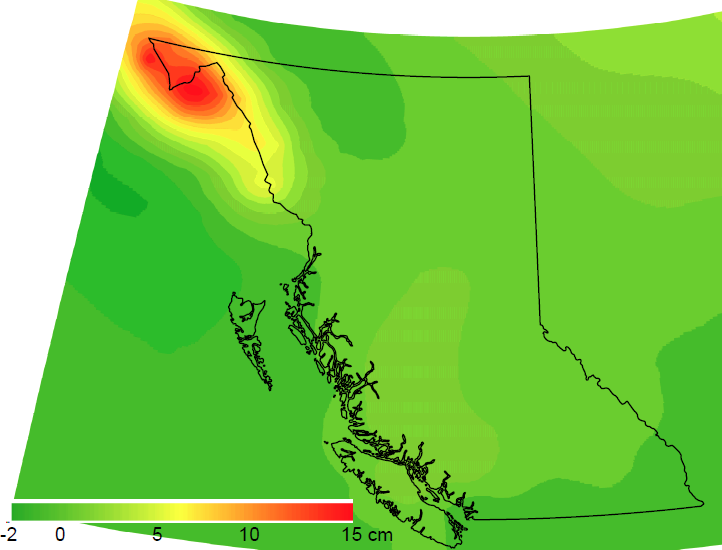
As shown in Figure 2, the difference between Epochs 1997.0 and 2002.0 is less than 2 cm for most of the province. Therefore, end users should take consistency with past GNSS-derived heights into consideration as opposed to attempting to achieve the best theoretical accuracy WRT the CGVD28 datum.
In accordance with the above notes, GeoBC advises surveyors in BC to continue using the HTv2.0 (1997) model to determine CGVD28 heights via GNSS with the exception of the note below concerning the Stikine and Kitimat Stikine Regions.
Special consideration: Stikine and Kitimat Stikine Regions
 Figure 2: Difference between HTv2.0 (1997) and HTv2.0 (2002) in BC
These two regions in northwestern BC have varying uplift of the earth’s crust that ranges from 0 to 3 cm per year. Therefore, the difference between HTv2.0 (1997) and HTv2.0 (2002) can be as much as ~15 cm in these regions. If absolute accuracy within CGVD28 is a priority, users should consider using the HTv2.0 (2002) model if their observations are connected to an ACS station with an ellipsoidal height referenced to NAD83(CSRS) Epoch 2002.0. However, users should also be aware that this approach will introduce an inconsistency with previous projects that were referenced via the original HTv2.0 (1997). It is up to the end users conducting work in these regions to determine whether the priority is to achieve better absolute accuracy (with respect to CGVD28) or better consistency with past projects. The epoch of HTv2.0 must be chosen in accordance with the desired goal of the end product and users are strongly advised to state which epoch of HTv2.0 was used in deriving their orthometric heights.
Special Consideration: Vancouver Island
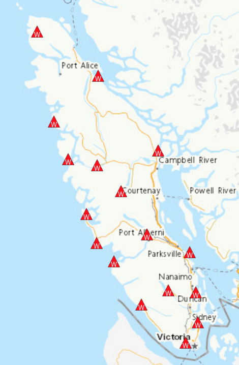
As the official horizontal datum on Vancouver Island is NAD83(CSRS) Version 3 Epoch 1997.0, then users of WCDA stations and private networks will have typically been holding fixed the Epoch 1997.0 ellipsoidal heights of those stations. Therefore, the use of HTv2.0 (1997) was, and continues to be the correct practice for both consistency and absolute accuracy purposes for projects on Vancouver Island.
 Figure 3: WCDA Stations on Vancouver Island
Special Consideration: Metro Vancouver and Abbotsford
In Metro Vancouver and Abbotsford, surveyors are advised to continue using HTMVBC00_Abb as directed on this page: https://www2.gov.bc.ca/gov/content/data/geographic-data-services/geo-spatial-referencing/geoid-model-data
HTMVBC00_Abb is a regionally enhanced version of HTv2.0 (1997).
Naming Convention of Height Transformation Model Binary Files
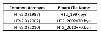
“HTv2.0” has been the acronym commonly used to identify the hybrid geoid model (based upon CGG2000) up to this point in time. However, this acronym is not suited as a binary file name. In creating the binary file names, “v70” was also appended which serves to inform end users that the CSRS Version 7.0 velocity model was used to propagate the original Epoch 1997.0 geoid-ellipsoid separation (N) values to Epoch 2002.0 and Epoch 2010.0 N-values. The common acronyms and their corresponding binary file names are listed below to avoid confusion in this regard:

Summary
Surveyors are advised to use the various models available to them as listed below:
- Vancouver Island: continue using HTv2.0 (1997)
- Metro Vancouver and Abbotsford: continue using HTMVBC00_Abb
- Stikine and Kitimat Stikine regions: choose between HTv2.0 (1997) and HTv2.0 (2002) depending on whether alignment with historical data or achieving better absolute accuracy is a priority.
- All other regions: continue using HTv2.0 (1997)
Given the existence of multiple epochs of HTv2.0, surveyors are advised to keep a record of the epoch of the ellipsoid height of their reference stations along with the epoch of the model was used to determine their heights for all future projects.
