National Forest Inventory Program

Introduction
The National Forest Inventory – British Columbia Program (NFI-BC) reports the current status of the forests in B.C. It also monitors any changes that occur over time.
NFI-BC’s permanent plot design allows for the repeated measuring of forest attributes at defined locations. Its expanded photo-based program helps improve the tracking of changes in tree growth. The program has also increased the set of ecologically based data collected on the ground.
Improving reporting and monitoring through expanded data collection
The program operates at the provincial and, ultimately, national levels. It provides the status and trend data on 25 attributes of sustainability. NFI-BC’s permanent, remeasurable design uses a statistics based system for monitoring and reporting that can be completed in conjunction with the national program. This improves upon past systems that relied on slower reporting methods.
The program design components
The NFI-BC involves two separate types of permanent plots:
- Photo plots
- Ground plots
Both can be remeasured at regular intervals over time.
Photo plot program
The first measurements for the Photo Plot Program were initiated in the fall of 2002.
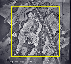
This program uses 2,414 permanent locations throughout the province. Each plot centres on a co-ordinate determined from a national 20 kilometres × 20 kilometres grid network. Each grid intersection, or node, is the centre point for a plot that encompasses an area 2 kilometres × 2 kilometres in size. In total, all the provincial photo plots equal about 1% of the land area of British Columbia.
For the majority of the photo plots, data came from existing forest inventory digital data files. New photo interpretation occurred in areas where data was not currently available.
 Each photo plot encompasses an area 2 kilometres × 2 kilometres in size where broad changes in the land base will be monitored.
Each of the photo plots measured in this program is updated with disturbance information. The forest attribute projection is reported yearly to account for any growth that occurs. This ensures the photo plots will be the primary source of data used in monitoring any broad changes that occur on the provincial land base. Data not obtained from the photo plots (such as the biomass of down woody debris) is collected in the Ground Plot Program.
The attributes measured to determine the amount of change include:
- Current land cover
- Tree species composition
- Age and volume (cubic metres per hectare)
- Disturbance activity
- Land use changes (such as reforestation, afforestation and deforestation)
- Mortality
- Access and human influence
- Soil erosion
The photo plots also cover non-forested locations, such as urban areas and water bodies. These are also monitored to determine change.
Ground plot program
The first measurements for the Ground Plot Program were started in the summer of 2000.
This program amounts to a subset of the Photo Plot Program, involving only 268 of the 2,414 potential photo plots. The province-wide plots are visited regularly on the ground for field data collection.
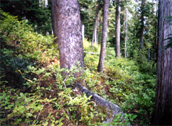
Ground plots have geo-referenced locations and tagged trees, which allows for regular forest monitoring. They are hidden from general view as much as possible to prevent influence from any nearby management activities.

Ground plots are not physically protected or openly demarcated. Vegetation may thus be removed or otherwise altered to reflect current management practices.
Plot locations may fall on:
- Crown land (including provincial parks and protected areas)
- Private land
- Forest woodlots
- Tree farm licences (TFLs)
- Community watersheds
No work is undertaken in any ground plot without appropriate permission. All data collection centres on a common plot location. Timber, ecological and site information comes through a combination of line transects and nested fixed-radius plots of varying sizes.
Ground plots monitor growth measured in individual trees; succession changes in non-tree vegetation characteristics; and mortality in individual trees.
The types of current data that can be reported include:
- Mensurational information, such as the volume per hectare and basal area of the timber
- Average age and height of the dominant trees in the plot
- Average stem diameter
- Species presence
- Relative amounts of shrubs and herbs
- Shrub and herb biomass
Changes within individual plots are reported after the first remeasurement cycle. Collective plot changes are also reported at this time.
Global warming
Monitoring forests on a regular basis is one of the best ways to determine the impacts of global warming.
Partnership
The National Forest Inventory is co-ordinated by the Canadian Forest Service. It is an interagency partnership of:
- Federal departments
- Provincial governments
- Industry
For additional information, see the National Forest Inventory
NFI field forms
NFI and VRI use the same field forms. Click to access the listing (Cards No. 1 to 16) and to download those forms.
NFI uses four additional ground sampling field forms (Cards No. 17 to 20) not used in VRI.
Please refer to the Ground Sampling Change Monitoring Inventory (CMI) Standards and Procedures Manuals.
Contact information
For more information on the National Forest Inventory Program, contact Forest Productivity and Sample Data Acting Team Lead
